
By Martin Helmke1, Daniel Bochicchio2, Jeffrey Leberfinger3, Gregory Schultz4
1Department of Earth and Space Sciences, West Chester University of Pennsylvania
2Groundwater and Environmental Services, Inc.
3Exploration Instruments, LLC and PIKA International Inc.
4White River Technologies, Inc.
Abstract
High-resolution remote sensing and geophysical surveys are instrumental for monitoring the evolution and impact of coal mine fires. This study demonstrates the application of unmanned aerial systems (UAS) to investigate the coal mine fire in Centralia, Pennsylvania. As the fire advances, high temperatures and ground subsidence continue to threaten this once thriving community.
This investigation employed electro-optical (EO), thermal infrared (IR), LiDAR, and magnetometer payloads on UAS platforms. EO and thermal IR imagery was collected using a Zenmuse XT2 camera flown by a DJI Matrice 210 UAS. The LiDAR data were recorded using a LiDAR USA Revolution 120 from Exploration Instruments, Inc. An atomic, optically- pumped magnetometer with a noise floor of 1 pT was flown at an altitude of 10 m AGL by a DJI Matrice 600 Pro UAS. Digital photomosaic maps of EO and thermal IR imagery were generated using the photogrammetry software Pix4D. LiDAR data were processed using Cloud Compare software. Magnetic anomalies were mapped using MATLAB.
UAS remote sensing and geophysics data revealed an exothermic landscape impacted by subsidence. EO photogrammetry documented subsidence; however, vegetation obscured ground features which reduced the method’s accuracy. Thermal IR recorded ground temperatures up to 40 °C. Surface temperatures were greatest in the western portion of the study area where the fire is most active. Interestingly, surface temperatures were significantly cooler than the record 237 °C measured at ground surface in the 1980s, suggesting that the fire may be slowing down and diminishing in size. LiDAR resolved numerous subsidence features that correspond with the locations of late 19th century room and pillar mines 20 m below the ground surface. The magnetometer readily detected the steel casing of a decommissioned well that had been used to monitor subsurface temperatures and gas concentrations in the 1980s. Collection of remote sensing and geophysical information by UAS produced more accurate and higher resolution data than afforded by traditional aerial methods. Moreover, the combination of EO, thermal IR, LiDAR, and magnetometer data allowed for a more sophisticated, synergistic analysis of the study area.
Introduction
Recent advances in UAS and payload technologies enable collection of high-resolution remote sensing and geophysical data. As with any scientific tool, an understanding of the benefits, limitations, and proper application of these methods is vital for conducting a successful investigation. Deploying sensors by UAS also requires the knowledge and skill to fly the aircraft safely, effectively, and legally. The objective of this study is to evaluate the use of EO photogrammetry, thermal IR, LiDAR, and magnetometry to investigate decommissioned wells, coal fires, and subsidence. The combination of datasets created by these diverse sensors is likely to provide greater insight than any single method.
Abandoned wells, coal fires, and subsidence are three pressing geologic issues that benefit from use of drone-borne remote sensing and geophysics. Due to the rapid rise and decline of the petroleum industry in Western Pennsylvania between 1859 and the mid-1920s, hundreds of thousands of abandoned petroleum wells are scattered across the Commonwealth (Kang et al., 2016). Many of these wells emit toxic or explosive gases, threaten water quality, or cause subsidence. Identifying, characterizing, and mitigating these wells is a priority in Pennsylvania and surrounding states. Coal mine fires are another significant challenge from late 19th century industry. There are currently 241 coal mine fires burning in the United States, including 38 in Pennsylvania (PADEP, 2020). Coal mine fires emit high concentrations of carbon monoxide and other toxic gases, can cause combustion of structures, and accelerate mine subsidence. Nationwide, subsidence caused by mine collapse, groundwater extraction, sinkholes in karst, and other mechanisms costs between $125 and $300 million annually (Galloway et al., 1999; Weary, 2015).
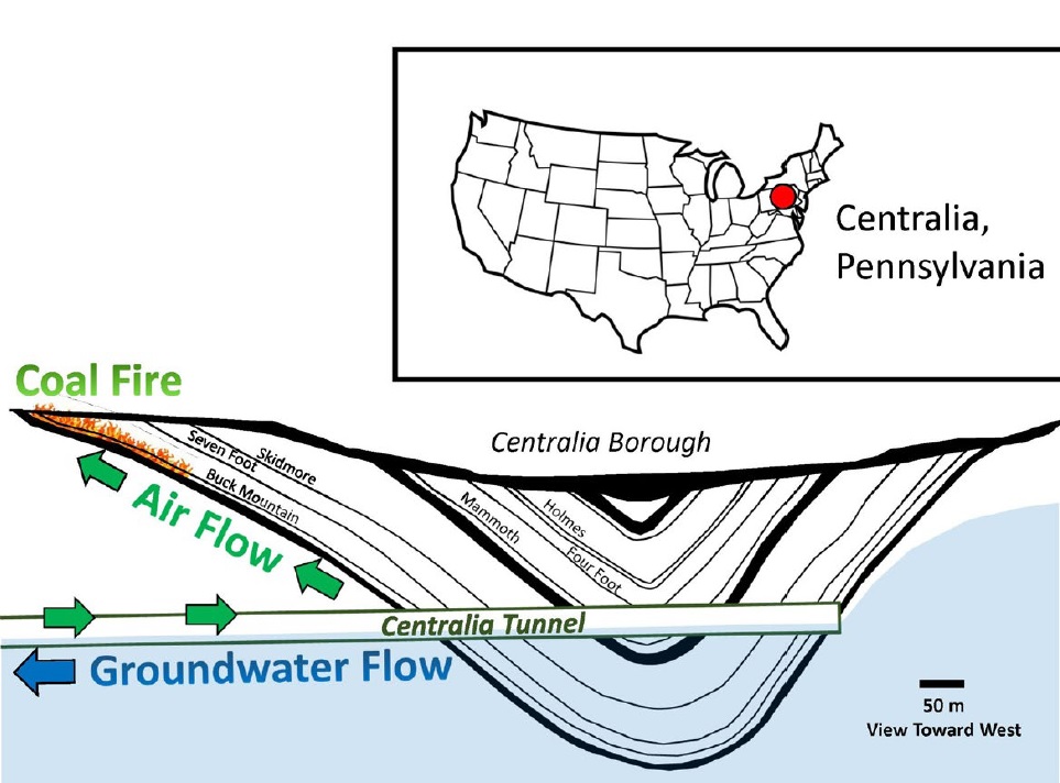
Figure 1. Location map of Centralia Pennsylvania and a schematic cross section of the mined coal beds within the Centralia Syncline. The Centralia Tunnel lowered the water table and introduced air to the mine workings, allowing the coal fire to burn.
The former coal mining town of Centralia, Pennsylvania (Figure 1) was selected for this study because it offers an active coal mine fire, numerous (some decommissioned) thermal monitoring wells, and subsidence. Located in the Western Middle Anthracite Field of Columbia County, Pennsylvania, the Centralia fire was reportedly ignited by trash burning in May 1962 (PADEP, 2020). After 8 unsuccessful attempts to extinguish the fire between 1962 and 1980 (Chaiken et al., 1980), the threat of subsidence and elevated indoor concentrations of carbon monoxide led to the relocation of approximately 1,200 residents from Centralia Borough and nearby Byrnsville by 1992. Today, most of the buildings in Centralia have been razed and only a handful of residents remain.
The labyrinth of mines beneath Centralia provides near ideal conditions for a coal fire. The coal beneath and adjacent to Centralia Borough was extensively mined by room and pillar methods during the second half of the 19th and early 20th centuries. Miners exploited ten coal beds (from the Buck Mountain to the Holmes) within an east/west-striking syncline of the Pennsylvanian Llewellyn Formation. The Centralia Tunnel was installed in the 1860s to drain groundwater from the mines into the Mahanoy Creek Watershed 1.5 km to the southeast. This tunnel lowered the water table approximately 70 m (PADEP, 2020) and introduced air, providing combustible conditions for the coal fire. Since 1962 the coal fire spread within the Buck Mountain bed along strike to the west, southwest, and east. In the 1980s, ground vent temperatures exceeded 315 °C and the fire advanced 20 to 23 m per year (GAI, 1983). Early estimates predicted the coal fire could encompass 1,500 ha and burn for 400 years. By 2011, however, the fire had cooled significantly (vent temperatures less than 65 °C) and the western fire front had slowed to 2 m per year (Elick, 2011). To date, the fire has only consumed approximately 160 ha (PADEP, 2020).
Deploying EO, thermal IR, LiDAR, and magnetometer sensors from a UAS is an area of active research. We found the UAS- based approach for this site to be particularly beneficial due to the complexity of the terrain, vegetation cover, and areal extent of the study area. High-resolution EO cameras suspended by stabilizing gimbals are routinely mounted on contemporary UAS. Overlapping imagery from these cameras may be assembled into orthomosaics and 3-dimensional digital elevation models (DEMs) using photogrammetry software. UAS EO maps are very high resolution, with a typical ground sampling distance (pixel resolution) of 2 cm, a horizontal accuracy of 6 cm, and a vertical accuracy of 12 cm. EO photogrammetric models have been used for many applications, including documenting mine subsidence (C´wiakała, 2020). Thermal IR provides accurate measurement of ground surface temperature and has been used to identify gas emissions and monitor mine fires (Li et al., 2018). UAS LiDAR records millions of survey measurements with 5 cm accuracy (Bakuła et al., 2017) and can monitor subsidence and ground disturbance beneath the tree canopy. UAS-borne total field magnetometers are used to detect magnetic objects such as steel well casing, pipelines, and unexploded ordnance (Nikulin and de Smet, 2019). Employing all four methods better constrains the data and provides an opportunity to conduct a more thorough investigation of wells, coal fire heat emission, and mine subsidence at Centralia.
Methods
EO data were collected using a DJI Phantom 4 Pro UAS equipped with a 20 megapixel camera with a 2.5 cm CMOS sensor and mechanical shutter. Images were also recorded during thermal IR flights with the Zenmuse XT2 12 megapixel visual sensor. Autonomous EO flights were flown at an above ground altitude of 60 m with a 75 percent frontlap and sidelap. Images were compiled to produce digital orthomosaics and 3D models using the photogrammetry software Pix4D (Vautherin, 2016).
IR thermal images were collected with the Zenmuse XT2 camera mounted on a DJI Matrice 210 UAS (Figure 2a). This instrument uses a FlIR sensor that measures thermal emissions in the far infrared between 15 and 1,000 µm wavelengths. The camera has a 640 x 520 pixel resolution, a 13 mm focal length, and a maximum precision of 0.1 °C.
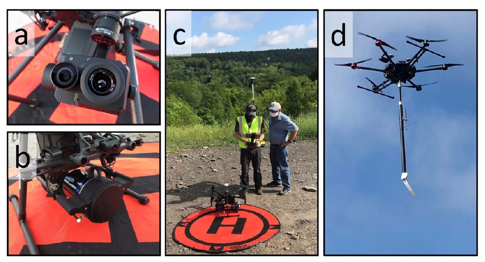
Figure 2. UAS instrumentation, including (a) Zenmuse XT2 thermal IR camera, (b) and (c) LiDAR USA/Exploration Instruments LiDAR on a DJI Matrice 210 UAS, and (d) a White River Technologies magnetometer deployed by a DJI Matrice 600 Pro UAS.
A LiDAR USA Revolution 120 M8 laser survey instrument, provided by Exploration Instruments, Inc., was used to collect LiDAR data for this project. This device is equipped with an 8-channel Quanergy sensor with a 150 m range, 903 nm laser that collects 440,000 points per second with an accuracy of 3.8 cm. At 1.7 kg, this is one of the few LiDAR packages light enough to be carried by the DJI Matrice 210 UAS (Figure 2b/c). The LiDAR instrument was flown autonomously at an above ground altitude of 50 m with a 50 m spacing at a velocity of 5 m/s for this study. Data were processed by ddms using Cloud Compare software (CloudCompare, 2020) to create a digital surface model (DSM) and digital elevation (bare earth) model (DEM).
An experimental total field magnetometer system provided by White River Technologies, Inc. was used for this research (Figure 2d). The instrument was equipped with an atomic, optically-pumped magnetometer with a noise floor of 1 pT. An autonomous magnetometer mission was flown using a DJI Matrice 600 Pro UAS programmed by UgCS software (SPH Engineering, 2020) at an above ground altitude of 10 m and a spacing of 5 m. Positioning and total magnetic field data collected on board were downloaded and evaluated using MATLAB software (MathWorks, 2020).
Results and Discussion
Data from the remote sensing and geophysical techniques were analyzed to facilitate interpretation of legacy well location, mine fire advancement, and subsidence. In each case a combination of methods was used to augment and validate the findings.
Legacy Well Location
Over 75 thermal monitoring wells were installed in the 1980s to monitor the temperature and gases emitted from the advancing fire front in Centralia. Since that time, many wells have become overgrown, decommissioned, or damaged by subsidence. Although different in construction and purpose from abandoned petroleum wells, these wells may serve as a reasonable proxy to legacy wells due to their thermal flux, age, and condition.
With a 2 cm ground sampling distance, EO maps contained sufficient resolution to identify many of the 20 to 25 cm diameter outer well casings by close inspection of the aerial imagery. In cases where wellheads were intact and unobstructed at the ground surface, these wells could be readily observed as small circles from the air (Figure 3). Some of these wells served as conduits to allow heat and gases to escape to the surface, disrupting nearby vegetation and producing a conspicuous patch devoid of vegetation.
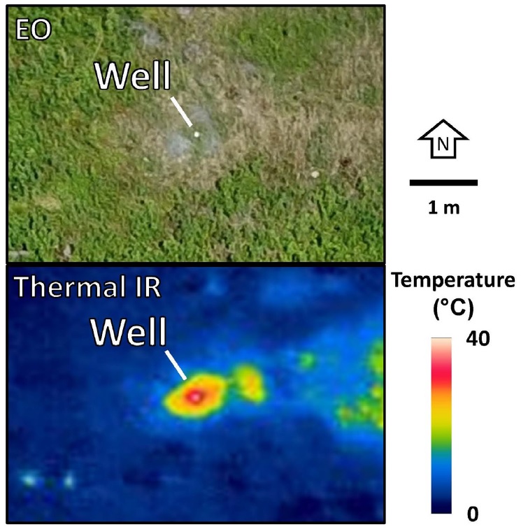
Figure 3. UAS imagery of thermal monitoring well N-4 using EO (top) and thermal IR (below) sensors. The EO image reveals the circular shape of the well and a patch of stunted vegetation (image captured in June 2020). A thermal IR image of the well captured in February 2018 shows the stark contrast in temperature of the 40 °C well casing against the surrounding snow.
Thermal IR imagery quickly revealed the locations of hot (typically 40 °C) thermal wells during cold weather when there was significant thermal contrast. For wells unheated by the mine fire, their temperature was usually sufficiently different from the surrounding soil and vegetation to be detected by the 0.1 °C precision of the thermal IR camera. Thermal was less effective at locating wells when wells were obscured by thick vegetation or in the spring and fall when ground surface temperature was similar to the well bore.
The UAS magnetometer readily detected the magnetic anomaly produced by a thermal well with intact steel casing (Figure 4). Upward continuation modeling was used to predict the response at greater flight altitudes. These simulations suggest that a 40 m altitude and a reduced flight grid spacing of 10 m would have been sufficient to detect the well and invert for its location and magnetic moment. Similarly, in cases where the upper steel casing has been removed (as is common for legacy wells), the sensor should remain capable of detecting residual casing 40 m below ground surface if the UAS is flown at a lower altitude. Continued development of inverse modeling could provide estimates of residual casing depth, which would be instrumental for developing abandoned well remediation strategies.
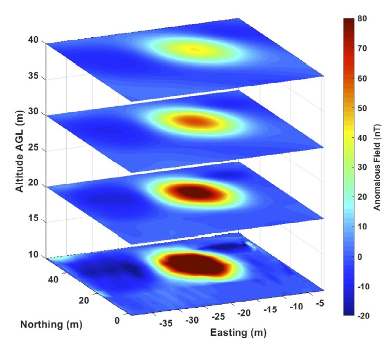
Figure 4. Measured total field magnetic anomaly detected by the UAS magnetometer flown 10 m above thermal well N-68. An upward continuation analysis of the gridded magnetic field reveals that the well would have been detected at an altitude of 40 m.
Although it would be difficult to use EO photogrammetry and LiDAR DTM to find such a small object as a well, these approaches would certainly detect subsidence, a well pad, abandoned road, or similar ground disturbance associated with legacy well construction and operation. LiDAR would be particularly useful for identifying relic well infrastructure beneath the tree canopy. In the case of Centralia thermal wells, EO photogrammetry and LiDAR identified the network of abandoned roads and streets that were used for drill rig access in the 1980s.
Coal Mine Fire Temperature Mapping
Conventional thermal IR imagery has been used to monitor the mine fire progress for several decades in Centralia (Elick, 2011). Recent studies concluded that temperatures are diminishing, and advancement of the fire front has slowed. The UAS thermal IR map (Figure 5) supports this conclusion, reporting a maximum ground temperature of 40 °C, far lower than the maximum temperature of 237 °C reported at ground surface in the 1980s. UAS thermography allows for cost-effective and therefore more frequent UAS thermography flights. Three thermal IR UAS mapping events between February 2018 and June 2020 have shown that the fire at Centralia appears to have stopped and is cooling or is moving deeper into the former mines.
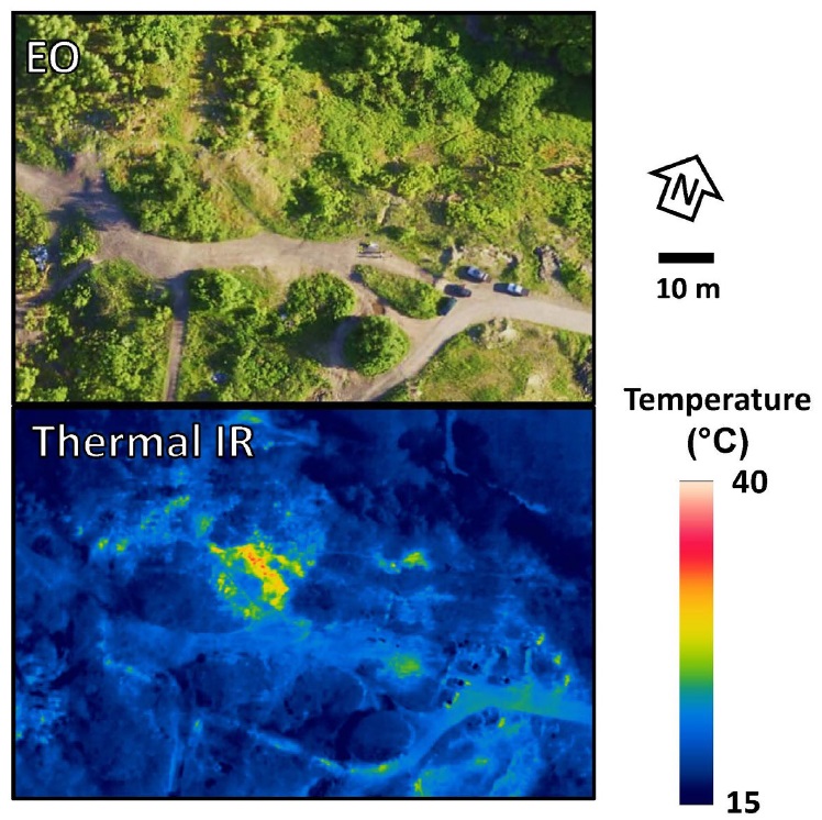
Figure 5. Drone EO (top) and thermal IR maps (bottom) of Centralia fire front 1 collected June 15, 2018. Vent temperatures are generally below 40 °C, much cooler than reported in the 1980s.
Subsidence Monitoring
Ground collapse and subsidence poses one of the greatest risks in Centralia. Much of the room and pillar mineworks from the late 19th century is now unstable due to age and combustion. EO photogrammetry of Centralia shows significant subsidence above the active fire front (Figure 6). An interpretation of the photogrammetric maps demonstrates the subsidence structures are 50 to 75 m apart, 20 to 60 m in diameter, and 2 to 4 m deep. Although the photogrammetric maps are high quality, with an estimated horizontal accuracy of 6 cm and vertical accuracy of 12 cm, vegetation obscures many of the subsidence features, rendering the technique less effective. Nonetheless, EO photogrammetry is an efficient method of constructing a DSM, allowing rapid measurement of subsidence volume and monitoring subsidence progression over time.
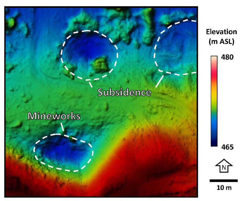
Figure 6. EO photogrammetry documenting subsidence in the area of the active fire front. Mine maps show that the mineworks are only 20 m below ground surface in this area.
The UAS LiDAR flights collected 78 million survey points over an area of approximately 6 ha, approximately 1,300 points/m2. This dataset was rendered and converted into a DSM (Figure 7). The EO orthomosaics and LiDAR DSM maps both show the significant influence of vegetation. These data were further processed to generate a bare earth DEM with a point density of 400 points/m2.
Analysis of the LiDAR DEM shows numerous subsidence features that correlate with the mineworks, coal seams, and fire location as noted previously by Elick (2013). The UAS LiDAR map is far more detailed than conventional LiDAR surveys and allows a more thorough assessment of subsidence than could be conducted by visual inspection in the field. This base map may now be used as a reference for future LiDAR surveys, allowing a precise measurement of changes in the landscape over time.
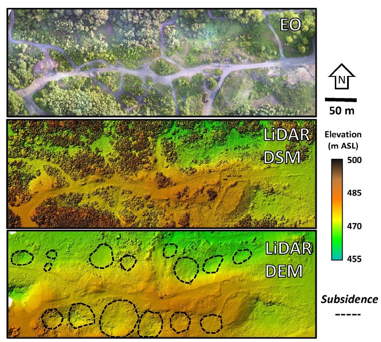
Figure 7. An EO orthomosaics, LiDAR DSM, and LiDAR bare earth DEM for southern Centralia, Pennsylvania. The LiDAR data reveal numerous subsidence structures that correspond with subsurface room and pillar mineworks.
Conclusions
UAS-deployed sensors produce rapid, frequent, and high-resolution remote sensing and geophysics data that can be applied to map and characterize legacy wells, delineate mine fires, and quantify subsidence. Use of multiple sensors, including EO photogrammetry, thermal IR, LiDAR, and magnetometry, provide complementary datasets that may be used to reinforce and validate conclusions. The strengths and limitations of each tool along with UAS deployment strategies should be well understood for any remote sensing or geophysics investigation. The coal mine fire of Centralia provides a useful case demonstration of these techniques, illustrating how they may be used with success else where.
Acknowledgements
We wish to thank the Borough of Centralia, James Andrews at the Pennsylvania Department of Environmental Protection District Mining Operations, ddms, Inc., FlIR, Dr. Sandra Mather, and WCU students Thomas D’Lauro, James Hannagan, and Joseph Spatafore for their support of this project.
References
Bakuła, K., Salach, A., Wziatek, D. A., Ostrowski, W., Górski, K., and Kurczynski, Z., 2017, Evaluation of the accuracy of LiDAR data acquired using a UAS for levee monitoring: Preliminary results: International Journal of Remote Sensing, v. 38 (8–10), p. 2921–2937, doi:10.1080/01431161.2016.1277044.
Chaiken, R.F., Brennan, R.J., Heisey, B.S., Kim, A.G., Malenka, W.T., and Schimmel, J.T., 1980, Problems in the control of anthracite mine fires: A case study of the Centralia mine fire (August): U.S. Bureau of Mines Report of Investigations 8799, 93 p.
CloudCompare, 2020, CloudCompare v. 2.6.1 User Manual, www. cloudcompare.org, 180 p.
Cwiakala, P., Gruszczynski, W., Stoch, T. , Puniach, E. , Mrochen, D., Matwij, W., Matwij, K., Nedzka, M., Sopata, P., and Wójcik, A., 2020, UAV applications for determination of land deformations caused by underground mining: Remote Sensing, v. 12, n. 11, 25 p., doi:10.3390/rs12111733.
Elick, J. M., 2011, Mapping the coal fire at Centralia, Pa using thermal infrared imagery: International Journal of Coal Geology, v. 87, p. 197-203.
Elick, J. M., 2013, The effect of abundant precipitation on coal fire subsidence and its implications in Centralia, Pa: International Journal of Coal Geology, v. 105, p. 110-119.
GAI Consultants, Inc., 1983, Engineering analysis and evaluation of the Centralia mine fire, Office of Surface Mining, 1 and 2, United State Department of the Interior, Monroeville, PA.
Galloway, D., Jones, D. R., and Ingebritsen, S.E., 1999, Land Subsidence in the United States, U. S. Geological Survey Bulletin 1182, 175 p.
Kang, M., Christian, S., Celia, M. A., Mauzerall, D. L., Bill, M., Miller, A. R., Chen, Y., Conrad, M. E., Darrah, T. H., and Jackson,
R. B., 2016, Identification and characterization of high methane- emitting abandoned oil and gas wells: Proc. Natl. Acad. Sci. Unit. States Am., v. 113, p. 13636–13641, https://doi.org/10.1073/ pnas.1605913113.
Li, F., Yang, W., Liu, X., Sun, G., and Liu, J., 2018, Using high- resolution UAV-borne thermal infrared imagery to detect coal fires in Majiliang Mine, Datong Coalfield, Northern China: Remote Sensing Letters, v. 9, n. 1, p. 71–80, doi:10.1080/2150704X.2017.1392632.
MathWorks, 2020, MATLAB desktop tools and development environment, version R2020a, 232 p.
Nikulin, A. and de Smet, T. S., 2019, A UAV-based magnetic survey method to detect and identify orphaned oil and gas wells: The Leading Edge, v. 38, p. 447–452, https://doi.org/10.1190/ tle38060447.1
PADEP, 2020, The Centralia Mine Fire Frequently Asked Questions/ Answers, Pennsylvania Department of Environmental Protection Bureau of Abandoned Mine Reclamation, link, accessed 8/30/2020, 14 p.
SPH Engineering, 2020, UgCS User Manual v. 3.6.225, www.ugcs.com, 87 p.
Vautherin, J., Rutishauser, S., Schneider-Zapp, K. Fai Choi, H., Chovancova, V., Glass, A. and Strecha, C., 2016, Photogrammetric accuracy and modeling of rolling shutter cameras, Pix4D, www. support.pix4d.com, 8 p.
Weary, D. J., 2015, The cost of karst subsidence and sinkhole collapse in the United States compared with other natural hazards: Proceedings, 14th Sinkhole Conference, Rochester, MN, p. 433-446.
Author Bios

Dr. Helmke is a Full Professor of Hydrogeology in the Department of Earth and Space Sciences at West Chester University of Pennsylvania, President of Helmke Hydrogeologic, LLC, and Past President of the Pennsylvania Council of Professional Geologists. He is an FAA-licensed drone pilot with over 20 years of experience applying fixed-wing and multi-rotor UAVs for scientific research and commercial clients. He is a scientific advisor to Groundwater and Environmental Services, Inc’s UAV services program. Current research projects include UAV magnetometer deployment strategies to map UXO and pipelines, multi-instrument detection of abandoned petroleum wells, multispectral fracture trace analysis, and geophysical characterization of sinkholes and subsidence. mhelmke@wcupa.edu

Dan Bochicchio is the Drone/UAV Technical Lead at GES with the duty of integrating new UAV technology into traditional geologic investigations and environmental services. His UAV work includes project progress monitoring and data governance modeling which he uses to train project managers and entry- level staff alike on how to derive data from a drone. His recent UAV projects have included HDD pipeline installation monitoring using thermal imagery, ROW monitoring and inspection, and integration of new sensor types into the UAV toolset. Prior to joining GES, Mr. Bochicchio led the development of the drone program at West Chester University. He later founded Skybernetics, a start-up consulting company specializing in the deployment strategies of UAV adoption. He earned his master’s degree from West Chester University in Geoscience, his bachelor’s at Appalachian State University in Environmental Geology and is awaiting his PG in PA. dbochicchio@gesonline.com

Jeffrey Leberfinger is a senior geophysicist with Exploration Instruments, LLC and PIKA International Inc. He is a licensed Professional Geophysicist (CA) and Geologist (PA) with over 30 years’ experience performing geophysical surveys across the US for Munitions Response/UXO, environmental, geotechnical, water resource, mineral exploration, and archaeological projects. A former Board of Director of the National Association of Ordnance Contractors (NAOC), Jeffrey is currently serving as the NAOC Technology Committee Chairman. He has also served on the Board of Directors of EEGS and the Pennsylvania Council of Professional Geologists (PCPG). jleblerfinger@exiusa.com

Dr. Schultz is the Chief Technology Officer at White River Technologies, Inc. and Principal Investigator for geophysical system DOD research and development programs such as the ESTCP project MR19-5212. He has 18 years of experience with autonomous sensing, geophysical data processing and inversion, simulation, and implementation of miniaturized magnetometers in ordnance clearance, infrastructure, and environmental applications. He is leading multiple efforts to integrate advanced magnetometer and electromagnetic sensor payloads on a variety of unmanned systems including autonomous fixed wing and rotary aircraft and autonomous underwater systems. schultz@whiterivertech.com
