
By Xavier Comas1, Lee Slater2, and Andrew Reeve3
1 Department of Geosciences, Florida Atlantic University, Davie, FL
2 Department of Earth and Environmental Sciences, Rutgers University, Newark, NJ
3 School of Earth and Climate Sciences, University of Maine, Orono, ME
Published 10/08/2021
Abstract
Northern peatlands are unique ecosystems typically located in boreal latitudes that sustain unique habitats and species. They are a critical component of the global carbon cycle, acting both as a carbon reservoir (via peat accumulation after sequestration of carbon dioxide from the atmosphere) and as a carbon source to the atmosphere (by releasing methane and carbon dioxide, two greenhouse gases produced by microbes that thrive in the conditions found in peatlands). Although the ecology of peatlands has been well studied for many decades, the geological controls on peatland development and groundwater flow patterns are not completely understood. In Maine (USA), peatlands began forming about 10,000 years ago following the retreat of the ice sheets at the end of the last ice age. They formed in depressions, often starting as lakes or wetlands, within the landscape carved by glaciers and draped with sediments. Almost two decades of research in several peatlands in Maine suggest that glacial landforms buried beneath peatlands may play a key role in regulating both the hydrology (including the presence of open water pools at the surface) and release of methane gasses from peatlands. Subsurface images using an array of hydrogeophysical methods (including ground-penetrating radar, GPR) constrained with direct coring has revealed the presence of buried esker complexes beneath (or close to) surface pools. Hydrological measurements further suggest that the presence of these permeable esker deposits (mainly gravel and sand) may enhance the connection of peatland water to underlying groundwater and help sustain these pools. Whereas geological maps show that the presence of esker systems in Maine are widespread, satellite-derived digital elevation models (DEMs) reveal that they are often proximal to peatland boundaries, further suggesting that they may commonly extend below the peat formation and control hydrology and carbon dynamics in more peatlands than previously thought. Better understanding of how the critical zone influences coupled water and carbon cycling in northern peatlands may improve the understanding of their contribution to radiative forcing of climate as the climate warms.
Introduction
Boreal peatlands (located mainly between 50-60° N latitude) are a critical component of the global carbon cycle with recent studies estimating a carbon pool of 1.1 trillion tons when considering differences in accumulation rates around the world, being more than twice previous estimates of stored carbon in boreal systems (Nichols and Peteet 2019). Peatlands play a dual role in radiative forcing of climate by greenhouse gasses that induce changes in the radiation entering the Earth’s surface. First, they remove carbon dioxide (CO2) from the atmosphere and induce cooling. Second, they release methane (CH4) to the atmosphere, that drives an increase in the atmospheric CH4 burden and induces warming (Gorham 1991, Frolking et al. 2006, Baird et al. 2009, Gallego-Sala et al. 2018). Many uncertainties exist with regards to the controls on the spatial and temporal distribution of these gases in peatlands, and what processes may motivate the presence of gas accumulation hotspots and hot moments for gas release from peat soils.
A recently released vision for the next decade of investment in Earth Sciences by the National Science Foundation identifies 12 high-priority research questions, including ‘How does the critical zone influence climate?’(NAS 2020). This question reflects increasing recognition that the critical zone ‘influences moisture, groundwater, energy and gas exchanges between the land and atmosphere’. Results from nearly two decades of collaborative research in several northern peatlands in Maine seem to indicate that the critical zone (CZ) exerts a profound influence on coupled carbon and water cycling in northern peatlands, and may well explain the location of hotspots of methane gas accumulation and release to the atmosphere from these critically important carbon pools. In this article, we show how ground-penetrating radar (GPR) imaging of the critical zone below peatlands reveals the potential role of glacial esker deposits in regulating peatland development, hydrology and possibly carbon gas emissions.
Eskers and Peatlands in Maine
Eskers are glacial formations deposited by meltwater streams in tunnels from a retreating glacier. Eskers in Maine (including the Katahdin system of primary focus here) were formed during the most recent deglaciation (about 12,700 years ago) and are among the largest in the country. They originate in central Maine and extend up to 150km, approximately N-S. These eskers are dominated by sharp-crested landforms ranging from 3-50m in height, up to 150m wide, and being composed of poorly sorted sand, gravel and boulders (Borns 1963, Shreve 1985). Figure 1 shows the extent of most major esker systems in Maine (red lines) as inferred from surface geological maps (Thompson and Borns 1985) along with six peatlands investigated in this work.
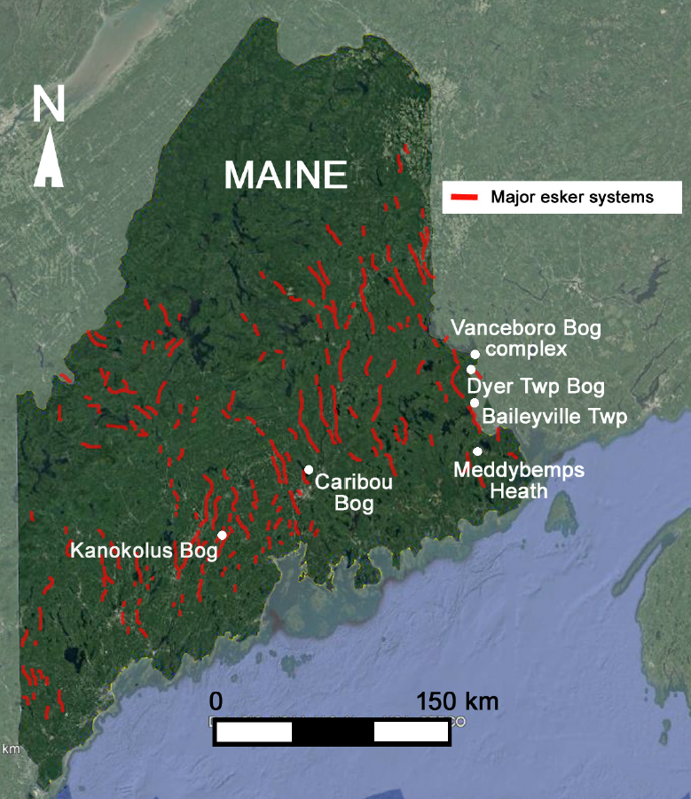
An estimated 6,000-8,000 peat deposits exist in Maine, accounting for approximately 2,000-3,000 km2 of total land area (Tolonen et al. 1988). Previous studies have identified over 1,100 peatlands via air photo surveys characterized by a wide variety of forms and features such as surface vegetation patterns and patterned pools at the surface (Davis and Anderson 1999, Davis and Anderson 2001). Davis and Anderson (2001) show that, from a total of 365 raised bogs (a rain-fed domed peatland) estimated for the state of Maine, about 80 (or 22% of the total) have pools. In this study, a subsample of representative raised bog complexes characterized by distinct surficial features (including arcuate pools and/or isolated elliptical pools), or by proximity to streams and lakes, were chosen to explore how buried esker deposits may influence peatland formation, water and carbon cycling and ultimately regulate climate in boreal regions.
Correlating Surface Digital Elevation Models with Subsurface Ground-Penetrating Radar (GPR).
We used a combination of newly developed digital elevation models (DEMs) and ground-penetrating radar (GPR) images to: (a) improve understanding of the relationship between surficial and buried esker deposits within the vicinity of peatlands; and (b) to explore the possible connections between pools in peatlands and buried esker deposits. Airborne lidar imagery was used to identify esker deposits not visible from geological maps or aerial images across the study region. A subset of new and previously collected GPR datasets, constrained with hydrological wells and direct coring, was used to identify buried esker deposits known to influence groundwater flow patterns (Bon et al. 2014) and possibly regulate the existence of surface features such as pools.
Geophysical Evidence for Critical Zone Controls on Surface Hydrology
Our understanding of how the CZ regulates peatland hydrology (and possibly carbon cycling) has advanced from the fusion of geophysical imaging technologies that illuminate the CZ structure beneath peatlands with DEMs that reveal complex esker systems. While an impermeable mineral substrate or low-permeability deep peat is generally considered essential during bog formation to reduce drainage (Reeve et al. 2000, Davis and Anderson 2001), computational simulations of groundwater flow (Reeve et al. 2009) and geophysical imaging (Comas et al. 2005, 2011) suggest that permeable sedimentary deposits such as eskers in contact with the peat will enhance vertical groundwater flow. There permeable deposits may act as conduits, hydraulically connecting peat deposits to the regional groundwater system, regulating water levels and allowing pool systems to persist over time (Comas et al. 2011).
Figure 2 compiles some of these results for the Central Unit of Caribou Bog, a multi-unit peatland representative of a boreal raised bog containing pools with a nearly two-decade record of hydrological and geophysical measurements. The inset in the upper right shows esker deposits surrounding the edges of the different peatland units reported in geological maps (Thompson and Borns 1985). The DEM image reveals the presence of smaller esker deposits (in red) characterized by discontinuous ridges that do not appear in the surface geological maps. These align with permeable deposits below the surface inferred from GPR images (Lines 1-3 modified from Comas et al. (2011),) as well as open pools at the surface. These permeable esker deposits are inferred to influence groundwater flow patterns, as supported by the flow vectors reported in Comas et al. (2011) and Chen et al. (2020).
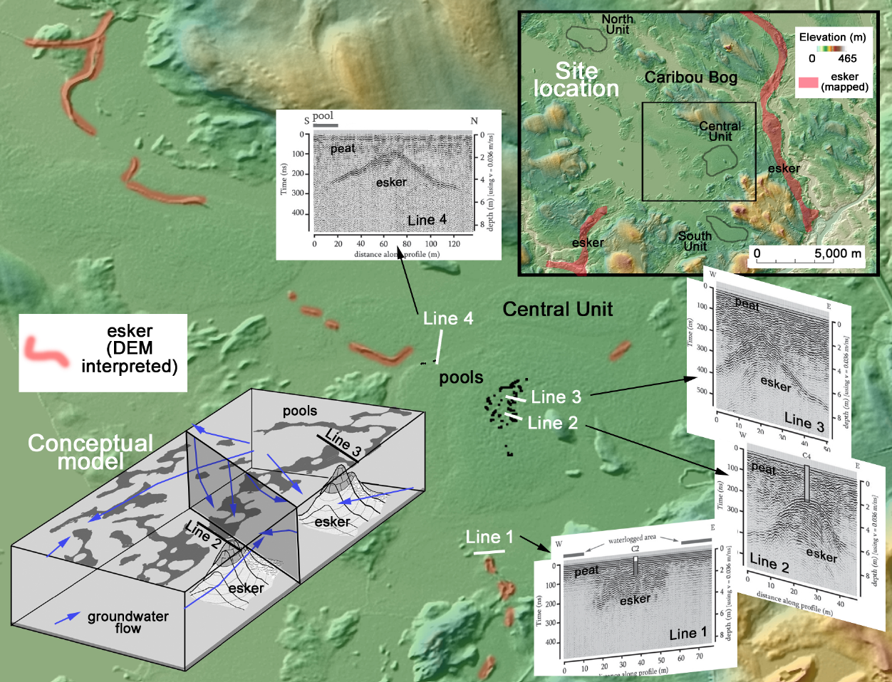
Evidence from further studies in Caribou Bog integrating gas flux measurements using a combination of static and dynamic chamber methods, modified gas traps, time-lapse cameras, hydrological measurements, and geophysical sensing (GPR, electrical imaging and capacitance probes) suggest a larger-scale role of the CZ architecture in regulating not just water levels in peatlands but possibly also gas dynamics and thus carbon cycling (Comas et al. 2007, 2008, Bon et al. 2014, Terry et al. 2016, Chen et al. 2020). A synthesis of these results in Chen et al. (2020) proposed that the glacial geology underlying Caribou Bog exerts the primary control on the peatland hydrology, influencing the formation of pool systems and the generation of hotspots of methane release. Earlier geophysical studies highlighted how sharp vegetation gradients in Caribou Bog also coincide with transitions in CZ structure (Slater and Reeve 2002, Comas et al. 2004), lending further support to the concept that CZ architecture may control surface processes in peatlands.
While limited in terms of observations when compared to Caribou Bog, results in a second peatland in Maine (Kanokolus Bog, also representative of a raised bog in Maine that contains pools) reveal similar associations between DEM and GPR datasets, supporting the presence of permeable esker deposits below its pool system (Figure 3). Although hydrological datasets are unavailable, coring and sampling of the mineral sediment confirmed the presence of sandy sediments characteristic of eskers associated with the crests identified in the GPR images that are different than the clayey mineral soil found along the edges of the peatland. Similar to Caribou Bog, geologic maps show known eskers surrounding the peatland (indicated as mapped eskers in Figure 3), with additional smaller esker deposits interpreted from DEM images (indicated as DEM interpreted eskers). These surface eskers appear, based on visual inspection, to align with subsurface esker deposits inferred from the geophysical survey (with open water pools at the surface).

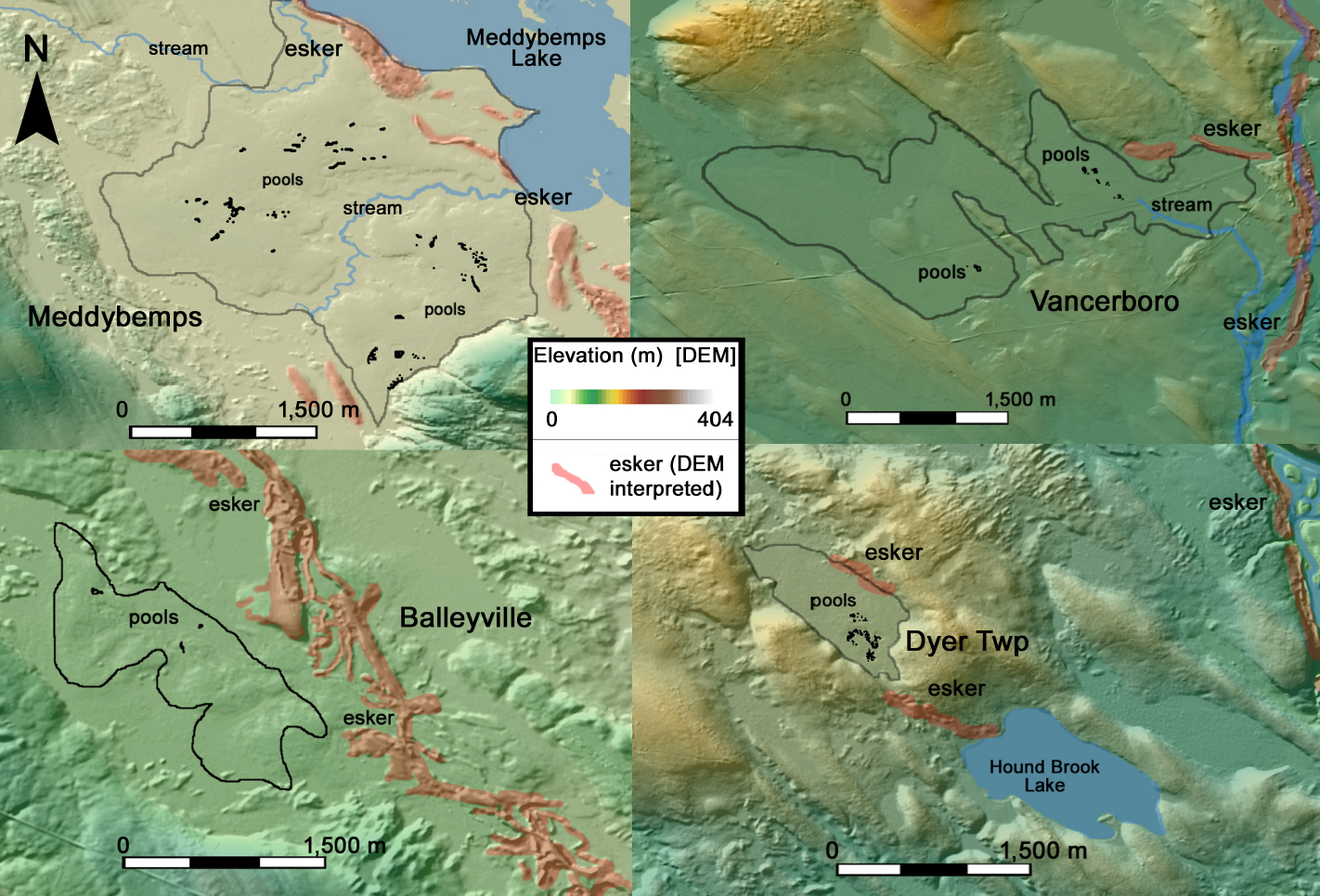
In order to evaluate potential transferability of our findings to a wider range of peatlands in Maine, Figure 4 shows four additional raised bogs that range in size, surrounding topography (some within distinct basins surrounded by higher elevations but others in relatively flat terrain), and surface drainage (some clearly draining to streams whereas others do not). While GPR measurements at these sites are currently lacking, the DEMs exemplify the variability in surface structure and highlight the proximity of these peatlands to interpreted esker deposits that follow the patterns described for Caribou Bog (Figure 2) and Kanokolus Bog (Figure 3).
Conclusions
While the ecology of peatlands is well understood, the geological controls on peatland development, along with the hydrology (i.e., groundwater flow) in peatlands, remain unclear. Peatlands in Maine began forming about 9,000-10,000 years ago following the retreat of the ice sheets and glaciers at the end of the last ice age. Glacial landforms associated with the retreat of these glaciers (including eskers) lie buried beneath these peatlands and may play a key role in regulating both the hydrology (including the presence of surface pools) and release of biogenic gasses (e.g. methane and carbon dioxide) in peatlands. The combination of GPR, and DEMs, supported by hydrological measurements and direct coring, reveals the importance of discontinuous eskers ridges in forming a CZ architecture that influences groundwater flow and the presence of surface features, such as pools, in boreal peatlands. Such controls are particularly important for predicting the gas fluxes, associated with radiative forcing of climate, from these peatlands and any positive feedbacks that result from spatiotemporal variations in greenhouse gas emissions from these important ecosystems.
Acknowledgments
This material is based upon work supported by the National Science Foundation under Grants No. EAR-2051350; EAR-2051907; and EAR-2052004. We thank all the undergraduate, graduate students, postdocs, and researchers that have helped in one way or another over the last two decades with collecting and/or processing some of the datasets presented here.
References
Baird, A., X. Comas, L. Slater, L. Belyea, and A. Reeve. 2009. Understanding Carbon Cycling in Northern Peatlands: Recent Developments and Future Prospects. Pages 1-3 in A. Baird, Belyea, L., Comas, X., Reeve, A. and Slater, L., editor. Carbon Cycling in Northern Peatlands, American Geophysical Union (AGU).
Bon, C. E., A. S. Reeve, L. Slater, and X. Comas. 2014. Using hydrologic measurements to investigate free-phase gas ebullition in a Maine peatland, USA. Hydrology and Earth System Sciences 18:953-965.
Borns, H. W. J. 1963. Preliminary report on the age and distribution of the late Pleistocene ice in north-central Maine. American Journal of Science 261:738-740.
Chen, X., X. Comas, A. Reeve, and L. Slater. 2020. Evidence for glacial geological controls on the hydrology of Maine (USA) peatlands. Geology.
Comas, X., L. Slater, and A. Reeve. 2004. Geophysical evidence for peat basin morphology and stratigraphic controls on vegetation observed in a Northern Peatland. Journal of Hydrology 295:173-184.
Comas, X., L. Slater, and A. Reeve. 2007. In situ monitoring of ebullition from a peatland using ground penetrating radar (GPR). Geophysical Research Letters 34:L06402.
Comas, X., L. Slater, and A. Reeve. 2008. Seasonal geophysical monitoring of biogenic gases in a northern peatland: implications for temporal and spatial variability in free phase gas production rates. Journal of Geophysical Research 113:G01012, doi:01010.01029/02007JG000575.
Comas, X., L. Slater, and A. S. Reeve. 2005. Stratigraphic controls on pool formation in a domed bog inferred from ground penetrating radar (GPR). Journal of Hydrology 315:40-51.
Comas, X., L. Slater, and A. S. Reeve. 2011. Pool patterning in a northern peatland: Geophysical evidence for the role of postglacial landforms. Journal of Hydrology 399:173-184.
Davis, R. B. and D. S. Anderson. 1999. A numerical method and supporting database for evaluation of Maine peatlands as candidate natural areas. University of Maine, Orono.
Davis, R. B. and D. S. Anderson. 2001. Classification and distribution of freshwater peatlands in Maine. Northeastern naturalist 8:1-50.
Frolking, S., N. T. Roulet, and J. Fuglestvedt. 2006. How northern peatlands influence the Earth’s radiative budget: Sustained methane emission versus sustained carbon sequestration. Journal of Geophysical Research 111:doi: 10.1029/2005JG000091.
Gallego-Sala, A. V., D. J. Charman, S. Brewer, S. E. Page, I. C. Prentice, P. Friedlingstein, S. Moreton, M. J. Amesbury, D. W. Beilman, S. Björck, T. Blyakharchuk, C. Bochicchio, R. K. Booth, J. Bunbury, P. Camill, D. Carless, R. A. Chimner, M. Clifford, E. Cressey, C. Courtney-Mustaphi, F. De Vleeschouwer, R. de Jong, B. Fialkiewicz-Koziel, S. A. Finkelstein, M. Garneau, E. Githumbi, J. Hribjlan, J. Holmquist, P. D. M. Hughes, C. Jones, M. C. Jones, E. Karofeld, E. S. Klein, U. Kokfelt, A. Korhola, T. Lacourse, G. Le Roux, M. Lamentowicz, D. Large, M. Lavoie, J. Loisel, H. Mackay, G. M. MacDonald, M. Makila, G. Magnan, R. Marchant, K. Marcisz, A. Martínez Cortizas, C. Massa, P. Mathijssen, D. Mauquoy, T. Mighall, F. J. G. Mitchell, P. Moss, J. Nichols, P. O. Oksanen, L. Orme, M. S. Packalen, S. Robinson, T. P. Roland, N. K. Sanderson, A. B. K. Sannel, N. Silva-Sánchez, N. Steinberg, G. T. Swindles, T. E. Turner, J. Uglow, M. Väliranta, S. van Bellen, M. van der Linden, B. van Geel, G. Wang, Z. Yu, J. Zaragoza-Castells, and Y. Zhao. 2018. Latitudinal limits to the predicted increase of the peatland carbon sink with warming. Nature Climate Change 8:907-913.
Gorham, E. 1991. Role in the carbon cycle and probable responses to climatic warming. Ecological Applications 1:182-195.
NAS. 2020. A Vision for NSF Earth Sciences 2020-2030: Earth in Time. The National Academies Press, Washington, DC.
Nichols, J. E. and D. M. Peteet. 2019. Rapid expansion of northern peatlands and doubled estimate of carbon storage. Nature Geoscience 12:917-921.
Reeve, A., Z. Tyczka, X. Comas, and L. Slater. 2009. The influence of permeable mineral lenses on peatland hydrology. Pages 289-298 in A. Baird, Belyea, L., Comas, X., Reeve, A. and Slater, L., editor. Carbon Cycling in Northern Peatlands. American Geophysical Union (AGU).
Reeve, A. S., D. I. Siegel, and P. H. Glaser. 2000. Simulating vertical flow in large peatlands. Journal of Hydrology 227:207-217.
Shreve, R. L. 1985. Esker characteristics in terms of glacier physics, Katahdin esker system, Maine. Geological Society of America Bulletin 96:639-646.
Slater, L. and A. Reeve. 2002. Understanding peatland hydrology and stratigraphy using integrated electrical geophysics. Geophysics 67:365-378.
Terry, N., L. Slater, X. Comas, A. S. Reeve, K. V. R. Schäfer, and Z. Yu. 2016. Free phase gas processes in a northern peatland inferred from autonomous field-scale resistivity imaging. Water Resources Research 52:2996-3018.
Thompson, W. B. and H. W. Borns. 1985. Surficial Geologic map of Maine. Maine Geological Survey.
Tolonen, K., R. B. Davis, and L. S. Widoff. 1988. Peat accumulation rates in selected Maine peat deposits: Maine Geological Survey, Bulletin 33. Maine Geological Survey Publications, 184.
Bios

Xavier Comas is a Professor in the Department of Geosciences at Florida Atlantic University. His research interests focus on the application of hydrogeophysical methods for the imaging and characterization of the critical zone, including nearly two decades of experience exploring carbon dynamics in peatlands worldwide from the tropics to the Arctic including boreal peatlands in Maine and subtropical systems like the Everglades. He is the current Past President of the Near-Surface (NS) Geophysics Section of the American Geophysical Union (AGU).

Lee Slater is a Distinguished Professor and the Henry Rutgers Professor of Geophysics at Rutgers University. His research focuses on near-surface geophysics and he has performed extensive hydrogeophysical research on peatland hydrology and carbon cycling. In 2013 he was awarded the Harold B. Mooney Award for long-term contributions in education and professional outreach in near-surface geophysics by the Society of Exploration Geophysicists (SEG) and the Environmental and Engineering Geophysical Society (EEGS). He was elected Fellow of the American Geophysical Union in 2018 for visionary experimentation in near-surface geophysics.

Andrew Reeve is a Professor in the School of Earth and Climate Sciences at the University of Maine. His research interests include the influence and interaction of groundwater flow on wetlands and surface-water systems, the impact of hydrology on carbon cycling in wetland systems, the use of computer models to understand groundwater processes, and application of the Python computer language to manipulate and analyze environmental data.
