
Hellen Gibson
Rod Paterson
Des Fitzgerald
Introduction
Excess density evaluations from detailed gravity methods can be successfully applied in both greenfields and brownfields exploration. Here we focus on brownfields, where investigating the extension of orebodies near to existing operational mine sites (brownfields) is the goal for prolonging mine life. The technique is very suitable because of the large amount of geologic control and geophysical data (e.g., ground gravity data) which is typically available or can be readily acquired.Here we outline a brownfields exploration workflow which utilises a geophysical inversion approach for usefully identifying zones of excess density. That is, zones where best-known geology constraints, and a justifiable 3D geological interpretation still cannot explain the observed gravity response. As such, the driven inversion outcome in terms of most-probable density can indicate clusters of high-density cells which may in turn indicate significant, and unaccounted for, massive sulphide mineralisation which would become drilling targets, especially if supported by other key indicators (for example, consistent with a SEDEX geological setting).
Employing forward modelling and inversion
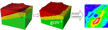
Figure 1 above shows a schematic of integrated 3D geological and density property modelling.
Forward modelling: From a 3D geology model and associated densities, one can calculate a geophysical potential field response (gravity) and compare it with observed gravity data (Figure 1, right).
If the calculated and observed responses don’t agree, we can try to infer geology from geophysics observations i.e. invert the above process, but this process is not unique.
Methodology
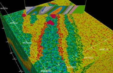
This workflow is best applied using high quality ground gravity surveys in combination with well constrained, prospect-scale 3D geology models (for example Figure 2).
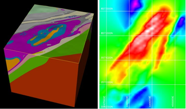
GeoModeller sofware; Right: The corresponding forward gravity response, from adopted mean densities per lithology unit.
We also advocate that ‘searching for excess density’ employs litho-constrained stochastic geophysical inversion, for example, based on a Markov Chain Monte Carlo formulation (Figure 3). So that rather than iterations ceasing when misfits reach a specified low limit (a deterministic approach), inversion continues and model perturbations (in geometries and densities), progressively explore potentially millions of possible models within an overlap zone representing all models supported within set-tolerances of our two independent data sets: the geology constraints and the gravity survey.
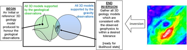
By this approach, millions of retained models are then analysed through statistical distillation and hence the inversion outcomes can be reported in terms of probabilities for geology-geometry and density in the initial geology model.
Inversion Workflow
Our recommended inversion workflow also includes some or all of the following preliminary stages:• A property optimization routine to determine optimum starting density values per lithology.• Prior only inversion runs to check the effective set-tolerances in the movable nature of geology boundaries within the initial or reference model.• Calibration using different discretisation schemes reflecting variable resolutions for the input geology and density models.
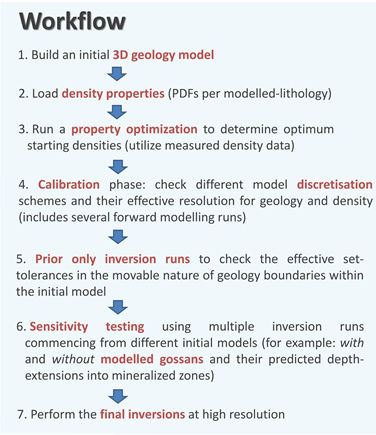
• Sensitivity testing, using multiple inversion runs commencing from different initial models, for example, with and without mapped gossans and their predicted depth-extensions into mineralized zones.
• Several forward modelling runs throughout preliminary stages to compute the gravity response directly from the evolving but pre-built 3D geology model and coupled density model.
Figure 4 shows more detail of the inversion workflow steps.
After preliminary stages, and when a fairly close match is achieved between the modelled and observed gravity – then preparations for a litho-constrained stochastic geophysical inversion are complete. Note that property optimization, forward modelling and inversion are all performed in GeoModeller on a discretised version (Figure 5) of a smooth 3D geology model (Figure 2). This facilitates model perturbations, computations, and statistical distillation of the inversion outcomes.
In the concluding stages, our workflow accesses masked 3D grids of most-probably density in the posterior models to reveal clusters
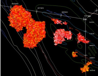
of high density in 3D, together with their volumes and locations as optimum drilling targets (Figure 6). Our inversion results also indicate volume changes between reference and final geology models – thus quantified indications of whether the ore-bearing geology units and their associated densities may have been over-estimated or under-estimated in the starting models. (Hopefully it’s the latter).
Least unambiguous results can be expected when there is a high density contrast between host rocks and mineralised lithologies.
Inversion Quality Control Checks
Inversion workflow and posterior model QC checks include the following:
• How were density values pushed around during inversion, as driven by the observed ground gravity? • How were geology volumes pushed around, especially those of the gossans and sulphides?
Final QC checks and questioning of the results includes:
• Checking misfits of final gravity grids • Analysing the most probable mean densities, statistically-distilled from all the kept-models of converged solutions. Are they higher than initial mean densities? • Analysing the most probable geology-geometries, from converged solutions. Are there any positive volume changes to the ore-bearing units?
Drilling targets
Finally drilling targets (Figure 6) can be identified (Figure 5) by: -Identifying the nature and size of significant clusters of high density – Use prior geological knowledge and inversion results to assess the possibility they indicate disseminated to massive sulphides.
Retrieve the geo-locations of high density clusters and design exploration drilling of the targets– Assess likelihood statistics of the volumes and densities of the clusters & set up the masked views of the posterior 3D grids/voxets.
Conclusions
We have outlined an exploration workflow using GeoModeller software which may usefully identify zones of excess density. That is, zones where best-known geology constraints, and a justifiable 3D geology interpretation still cannot explain the observed gravity data, such that the driven inversion outcome in terms of most-probable density, indicates clusters of high-density cells which may in turn suggest unaccounted for massive sulphide mineralisation given other key indicators are present, for example for a potential SEDEX deposit setting.We have: -Presented a brownfields exploration workflow for SEDEX deposits Illustrated principles of a Bayesian, integrated 3D geological modelling and gravity density inversion (litho-constrained stochastic geophysical inversion, based on a Markov Chain Monte Carlo formulation, implemented in GeoModeller software) – A superior modelling approach compared with conventional gravity modelling Demonstrated how posterior models of 3D density can be evaluated for their validity under quantitative methods founded in statisticsShown how excess high density clusters can be identified and rigorously characterised in 3D, and geo-located as direct targets for prospect-scale exploration drillingHighlighted the importance of this methodology, along with detailed ground gravity survey data, as a rigorous technique for exploration of massive sulphide mineralisation, e.g., SEDEX deposits in either brownfields or greenfields settings.
Author Bios
Helen Gibson
Geologist and Geological Modeller
Intrepid Geophysics,
Suite 110, 3 Male Street, Brighton, Victoria, 3186, Australia
Helen Gibson completed a Master of Science in Geology (tectonics and thermal history modelling) at the University of Melbourne in 1993.Her career experience includes near-mine and regional gold and base metals exploration (2 years); petroleum exploration services (thermal history modelling, 12 years with Geotrack International); and 12 years at Intrepid Geophysics in various roles including geothermal product development, software training and as Technical Sales Manager (5 years).In mid-2018 Helen began a career re-focus in the sustainable geoscience and renewable energy sectors. She’s an expert user of GeoModeller software and an experienced speaker.

Rod Paterson
Senior Engineer/Geophysicist Intrepid Geophysics,
Suite 110, 3 Male Street, Brighton, Victoria, 3186, Australia
rod@intrepid-geophysics.com
Rod has been with Intrepid since 2007. He is a multi-skilled geoscientist with 30 years’ experience in mining and exploring for tin, base metals, gold and heavy mineral sands. He holds a B.Sc in Geology and Geophysics and has proven analytical ability in the fields of geology, geochemistry, geophysics and remote sensing and a successful track record in ore resource/reserve estimation with experience in a wide range of commodities.Rod has demonstrated skills in the integration of multidisciplinary data in geographic information systems or image processing environments as well as the processing of ground and airborne magnetic and radiometric and other remotely sensed data. He also has many years of experience in software design and development with a strong focus on robust and user-friendly interfaces. Rod is a highly motivated self-starter with excellent long-term vision in exploration research and a proven record in report writing,

Des Fitzgerald
Director Intrepid Geophysics,
Suite 110, 3 Male Street, Brighton, Victoria, 3186, Australia
des@intrepid-geophysics.com
Des FitzGerald is the Managing Director and principal owner of Intrepid Geophysics (IG) (formerly Desmond Fitzgerald & Associates Pty Ltd). Des founded the company in 1978 as an independent consultancy specializing in the use of computer methods for mining and geophysics. He also co-founded MINDATA, (specialized Mining Research & Development Company) and was Chairman of that company for 14 years.Des has over 30 years’ experience with Intrepid Geophysics. His major projects have included: the development of the Intrepid geological processing system (software) with Geoscience Australia (GA); a complete compilation of Australian regional geophysical maps (both on shore and offshore) for magnetics, gravity, and bathymetry in partnership with Geoscience Australia (GA); and liaising with the French Geological Survey to further develop and promote new technology for 3D Geological mapping (3D GeoModeller) software integrated with potential field geophysics.Des holds a PhD in Mining Engineering from the University of Melbourne (Australia). He is a Director for Spatial Vision, a Director for RMIT Innovations Ltd, and the Chairman of GeoJAG. He is also a member of the Australasian Institute of Mining and Metallurgy (AIMM), Australian Industry of Petroleum (AIP), Mineral Industry Consultants Association (MICA), Society of Exploration Geophysicists (SEG), and the Australian Society of Exploration Geophysicists (ASEG). Des is based in Melbourne, Australia.
