
Continuing Doug Crice’s series reflecting on a life in geophysics.
Back in 2005, JEEG published my wittily-titled editorial: “MASW, The Wave of the Future”[1]. I proposed that MASW was going to be a major development in engineering seismic because the results would be particularly diagnostic in terms of material properties, useful to the engineering community, and at the same time, produce output that an engineer could easily understand and use.
At the time, MASW was more-or-less beyond the development stage, but yet to achieve widespread usage. MASW is now so ubiquitous that it isn’t necessary to spell out the meaning of the acronym. These days, JEEG has become more focused on publishing substantive scientific papers and such a paper wouldn’t pass the review process. FastTimes fills the need for diversified material outside the peer-reviewed universe. Even back in 2005, Rob Huggins told me that the board debated for an hour on whether to publish the article.
Surprisingly, people actually cite this article in academic papers. Sure, it’s a fun read, and in hindsight, quite prophetic, but it’s not serious scientific research.
How pervasive is MASW? Let’s see if we can figure it out. There are many MASW papers published, dedicated sessions at conferences, and workshops on how to do it. There are still discoveries being made in novel processing techniques and applications, so geoscientists get to talk about new things. But the real measure of the popularity of a method is its use outside the scientific research community by practitioners.
The word practitioners here is meant to categorize the folks who do routine geophysics in the service of real world problems, as opposed to advancing the science. These men and women search for bedrock, map faults, investigate earthquake site response, monitor landslides, look for karsts and tunnels, and a host of other geologic issues. They typically charge their time to a work order, often as employees of a larger engineering firm that doesn’t encourage taking time from revenue projects to write papers. When they do come up with an interesting case history, they generally don’t publish, often in the mistaken belief that the community at large isn’t interested in their work. MASW is a very useful technique.
A big factor in the growth of MASW was the serendipitous appearance of the Land Streamer, which allowed really-efficient data collection. The Land Streamer and MASW are in a symbiotic relationship—they work well together. Let me digress here to talk about the development of land streamers.
In the early 1980’s, Geometrics published an excellent article[2] that was a summary of 8 papers reporting the results of surveys conducted with land streamers. Dr. Gretchen Schmauder from Geometrics was kind enough to repost it on their web site. Each of the papers reported interesting results from surveys with land streamers. It was clear that land streamers offered an efficient way to collect decent data over significant acreage.
All of these land streamers were hand-made by the authors. Some sensors were 3-component, some were gimballed, and some used single vertical geophones. They used an eclectic variety of ground-coupling mechanisms. Since there were no side-by-side comparisons, it wasn’t determined which provided the optimum product since there are always trade-offs between cost, effort, and results. Some would provide better coupling and response to ground motion in a variety of ground surfaces. Designs that would work well on pavement might be totally unacceptable on grass.
There are papers on the effect of geophone coupling to the ground such as Hoover and O’Brien (1980)[3], Krohn (1985)[4] and others that the reader can locate with a search of the SEG Library. The results usually confirm what common sense would tell you: tight coupling between the geophone and the ground give you better data. This is especially true of shallow reflection data. Planted geophones provide better reflection data than land streamers because of the required high-frequency response. MASW, on the other hand, relies on low frequencies and thus is not as sensitive to coupling and geophone-soil interaction. MASW and land streamers are meant for each other.
Some designs are better than others. A good land streamer needs weight and teeth to dig into the surface for good coupling, and a sturdy tow mechanism with a means to protect the cables from the ground. Bonus features include a convenient means to adjust the geophone interval and tow fabric that doesn’t stretch under tension (which will continue to creep after stopping, extending the time required to move and shoot).
I felt that the system built by Rick Miller offered the best solution. He described it at SAGEEP[5], and there is a summary in the Geometrics paper. When I first read it, my thought was that this geophysicist (who also has a farm) just used stuff he had laying around the barn; in hindsight, the design exhibits brilliance. The base plate had weight and teeth to cut into the ground. The fire hose protected the cables and offered abrasion resistance combined with exceptional towing strength.
It seemed like someone needed to produce a commercial product if land streamers were going to be widely used—not everybody who wanted to do surveys with land streamers would have the time and resources to build their own. And some designs were better than others.
Geostuff built one. Since 2003, we have sold about 300 land streamers. Spread over almost 20 years, that is not a huge business, but consistent with Geostuff’s DNA of building products that the industry needs where the total worldwide market is too small for a large company to service. There are other vendors of land streamers, and other home-built systems. Virtually every firm in the geophysical instrument rental business has one or more land streamers in their inventory. This limited data set suggests that maybe there are somewhere between 600 and 1,000 scientists and engineers doing MASW with land streamers. Geophysicists in India, China, and Russia are not included in these estimates; we have never sold one into those countries.
Land streamers are such a small part of the cost of a seismic system that no serious investigator should be without one. Some studies, especially reflection surveys, might require the better data quality from planted phones, but tradeoffs between data quality and economics are often made in geophysics.
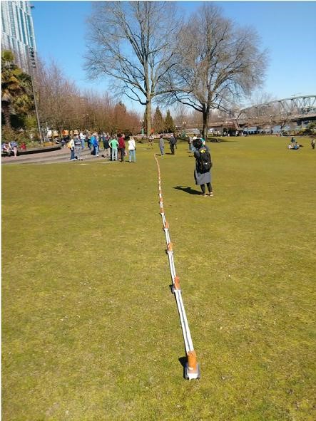
Many of the SAGEEP meetings included a workshop on MASW, usually with a land streamer employed. Here is one at the Portland meeting in 2019:
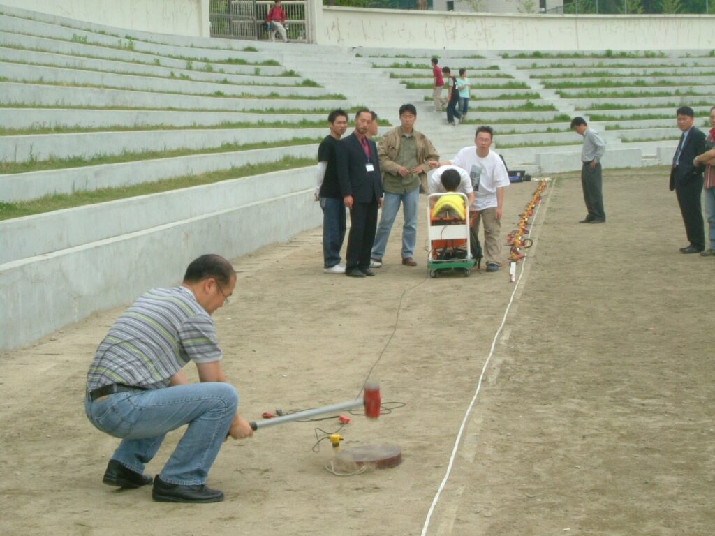
Similar seminars are conducted around the world such as this one in Korea:
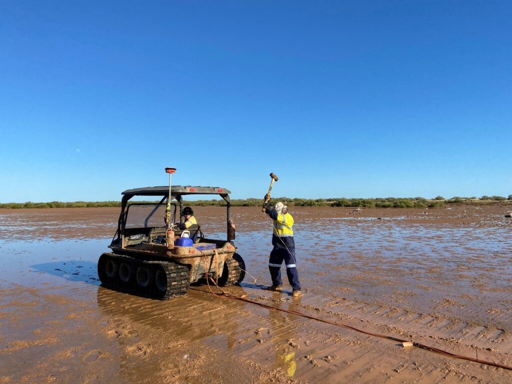
Which brings us back to MASW. People are doing surveys all over the world, in difficult conditions, such as this photo from Australia (courtesy of Andrew Spyrou of GBGMAPS)
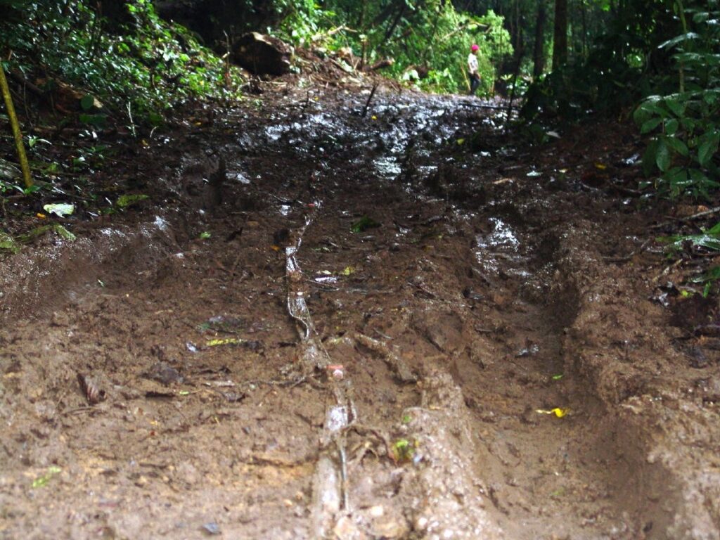
And here is one from a survey in Panama:
A lot of our sales are into the Middle East, reflecting the level of construction there driven by oil money. South American companies also represent a good proportion of sales. There are many geophysicists and engineers all over the world (who never attend SAGEEP) conducting MASW surveys.
Brian Herridge of 3D Geophysical is one of those practitioners who routinely conduct MASW surveys to address problems or questions. He never writes papers—just reports for his clients. However, he shared some interesting case histories for me to include in this article about how MASW is being used.
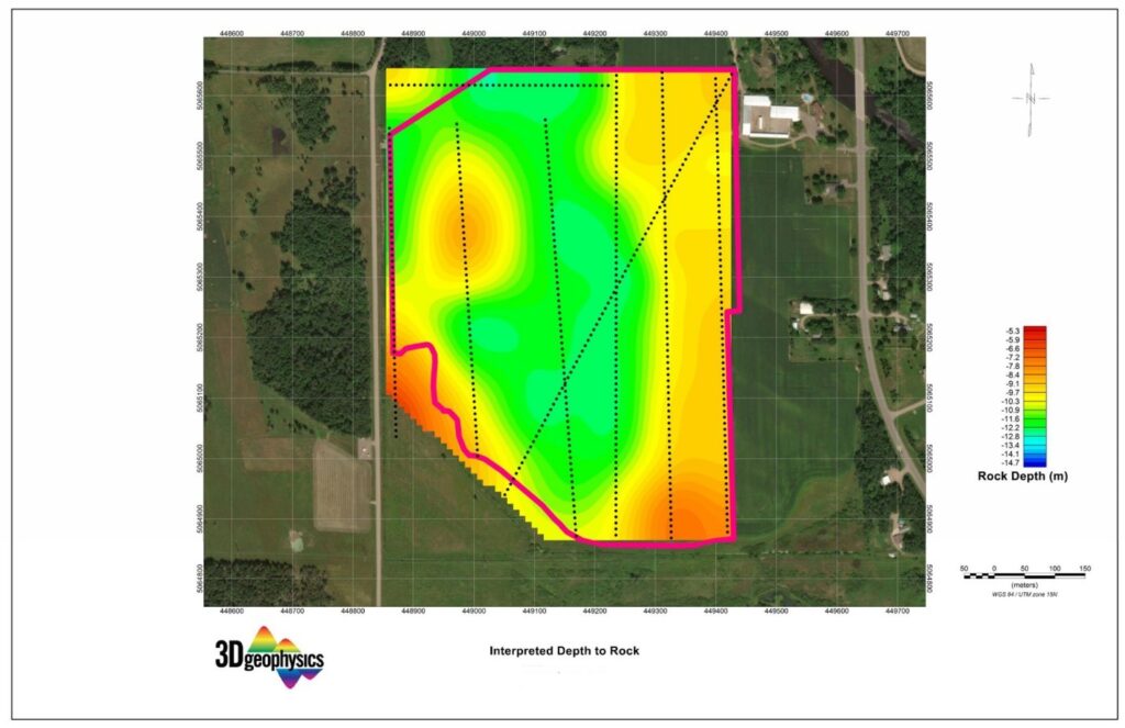
In the first case history, a gravel company was considering a 100-acre site as a source of aggregate. To determine the depth to bedrock and thus volume of suitable material, Brian collected data from eight lines over the area, using a towed accelerated weight drop source and land streamer. Here is a processed section of Line One:
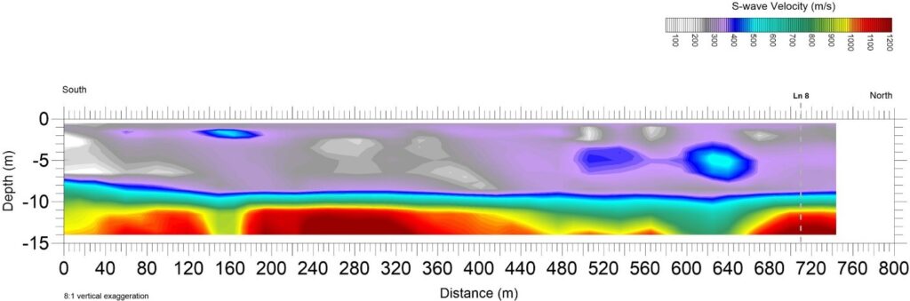
Nothing particular extraordinary about this survey except that the data from the 8 lines (~ 1 Km each) was collected in one day. The data was processed by Choon Park of Park Seismic. He produced this map of depth to bedrock over the site. The gravel company did two test wells to evaluate the aggregate, much fewer than might have been necessary without MASW. Of course this could have been done with a refraction survey, but it would have taken much more time and effort.
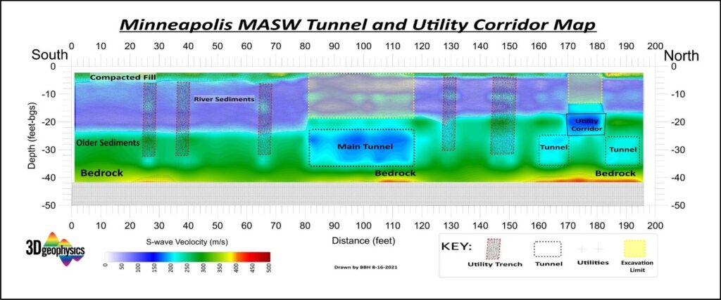
In a second case history, a multi-story concrete parking structure was planned to alleviate the enormous parking issues caused by the large sporting events. The structure will require a deep foundation without damaging or disrupting any of the underground assets. The MASW survey showed the locations of the tunnels and the utility corridor.
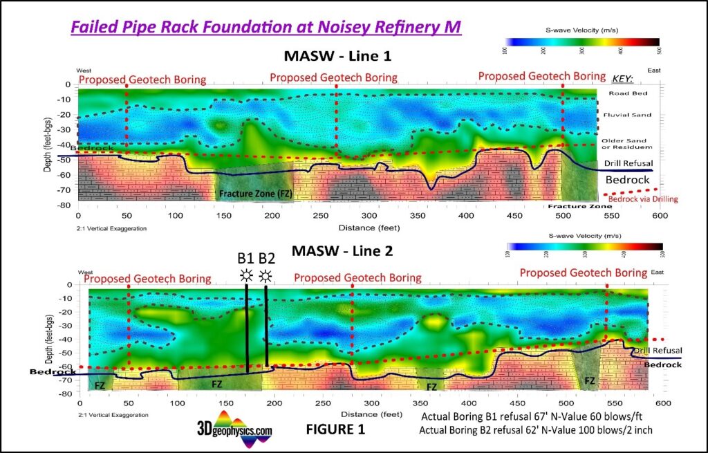
In the third case history, a 600-foot pipe rack in a refinery failed. Typically, the foundation engineer would propose drilling to evaluate the foundation—one hole in the center and two more near the ends as shown on the top image. All of the holes would encounter bedrock and provide little information about the problem. In this case, an MASW survey was done first, which is rare, but ought to be routine practice. The survey revealed the fracture zone. To test the MASW image, two holes were drilled 18 ft apart, confirming the results, verified by Standard Penetration Tests[6], with blow counts of 60 blows/ft in the fracture zone vs. 50 blows/inch in the bedrock.
Rippability
Rippability is a term which used to be used often by Caterpillar Tractor. The company makes a number of bulldozers equipped with a ripping tooth that penetrates the ground behind the tractor and rips up the material to facilitate excavation. In the early days of my career, rippability got some emphasis at Caterpillar. They published a “Handbook of Ripping” with a lot of information about excavating rock, including a series of tables to predict rippability based on seismic velocity. This is important of course because when excavating rock, ripping is much more economical than drilling and blasting, both for road construction and mining.
From the 2000 edition of the Handbook of Ripping, here is the ripping table for a D8 Tractor (Similar tables are in the handbook for other size tractors):
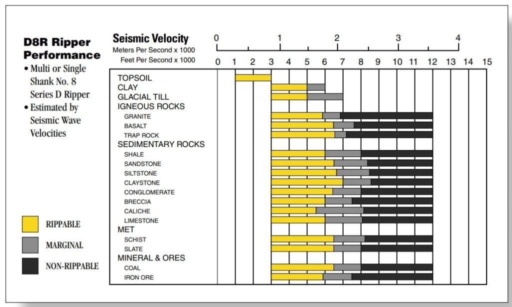
Judging by the variety of materials, Caterpillar put a lot of research into rippability. The handbook (link) refers to a RIP analysis that included a seismic survey. Despite the apparent history of serious interest, I could find nothing on the current Caterpillar web site with information on rippability, other than descriptions of their ripping tools.
The chart says that materials with a p-wave seismic velocity of 1500 meters/second can be ripped. If you were bidding a construction project, this would be really important information, so much so that you might hire a geophysicist to run out to the site and measure the seismic velocity in areas where there were significant cuts to be made. In my early career, Nimbus Instruments actually had a geophysicist in the company who would do group surveys to sell to the people bidding on a project. Contractors who were nervous about the unknowns would buy the report before bidding.
There are a lot of gray areas in the chart, figuratively and literally. How much is the granite decomposed? Is there groundwater in the fissures? I believe that much of the lack of precision comes from the fact that these are P-wave velocities, which are only marginally descriptive of rippability. If the shear-wave velocities were measured, it would tell us the shear strength of the material, a much better measure. Consider for example clean saturated gravels. The P-wave velocity will be about 1500 m/s, but the shear wave velocity might be as low as 100 m/s, depending on the amount of interstitial silt. With MASW, we can not only determine depth to bedrock and interlaying materials but also the shear wave velocity, and thus the shear strength.
Back in my early career, I had a friend, Steve Haverberg, who came to the geophysics meetings. Steve worked for Cat doing seismic surveys for their customers. This service isn’t available anymore. Caterpillar’s literature on rippability can be found on the web, but nothing newer than twenty years ago. The Cat web site seems to have nothing on seismic except for a little information on performance of their bulldozers, which makes me suspect that they have become less enamored of using seismic velocities for rippability. This is understandable of course, since P-waves are only marginally diagnostic. I reached out to them for more information, but received nothing which could be published.
Searching the web for articles on MASW and rippability revealed just a few references here, here and here ; considerably fewer than you would expect on a subject with serious implications for estimating the cost of excavation. It is clear that there is a research opportunity to relate shear wave velocity to rippability.
Conclusion
Reprising my earlier article, I think it’s safe to say that MASW has much potential to offer to the engineering community. This has been a goal of the Near Surface community for as long as I have been in this field[7]. I have to say that my early article was indeed prophetic, yet we still have not successfully communicated the value of MASW to the engineering community at large. We may be giving papers at the wrong meetings. As an aside, I would suggest a standard be developed for the colors used to represent shear wave velocities on MASW sections. Red, for example, should perhaps always represent competent rock, and blue loose topsoil, instead of the highest and lowest velocities on a particular section. That way, an engineer (or geophysicist) looking at a section could instantly recognize the material properties without having to look at the legend and mentally convert into shear wave velocity and then into useful information.
Author’s note: The editor of FastTimes suggested that I expand the discussion of land streamers. I would like to include several more case histories like the ones here. If you readers have any interesting MASW sections to share with me, please send them to dcrice@geostuff.com . Please include a short problem statement, a brief description of the survey, an MASW section and a brief analysis. Both interesting and mundane sections will be considered. Brevity would be good. The idea is to illustrate what people are doing in the real world as opposed to peer-reviewed papers. If I get some soon, they might get included in a presentation scheduled for Caterpillar early next year.
[1] Crice, D., 2005, MASW, The Wave of the Future, Journal of Environmental and Engineering Geophysics, volume 10, issue 2, https://doi.org/10.2113/JEEG10.2.77
[2] Geometrics Inc., A Report on Land Streamers: The Last Geophone You Will Ever Plant? http://www.geometrics.com/wp-content/uploads/2021/09/LandStreamers.pdf
[3] G. M. Hoover and J. T. O’Brien, (1980), “The influence of the planted geophone on seismic land data,” GEOPHYSICS 45: 1239-1253.
[4] Christine E. Krohn, (1985), “Geophone ground coupling,” The Leading Edge 4: 56-60.
[5] Miller, R.D., C.B. Park, K. Park, and R.F. Ballard, 2003, A 2-C towed geophone spread for variable surface conditions: Symposium on the Application of Geophysics to Engineering and Environmental Problems (SAGEEP 2003), San Antonio, Texas, April 6-10.
[6] A “Standard Penetration Test” involves dropping a 140-pound hammer 30 inches on a drill stem attached to a sampling tube 2 inches diameter and 1-3/8 i.d. Aside from its purpose to collect soil samples, the rate of penetration is an empirical measurement of shear strength of the material. It is widely used and recognized worldwide. Some studies have shown strong correlation between blow count (the number of impacts required for penetration) and shear wave velocity, suggesting that MASW could reduce the number and cost of standard penetration tests in foundation studies. I intentionally didn’t convert the units into metric, because the English units are part of the standard. When converted to metric, the numbers seem strange. Why would you drop a 63.5 Kg mass 760 mm?
[7] Some years ago, there was a conference designed to generate some synergy between geophysicists and engineers. It was really well organized, with tutorial papers on geophysics for engineers and engineering for geophysicists. The attendance at the geophysics seminars consisted of the geophysicists, and the engineers went to the seminars on civil engineering, so that didn’t work. At the end, there was a terrific half-day demonstration of engineering work and a variety of geophysical surveys. That created a little more cross fertilization, in that the geophysicists got to watch interesting things like drilling and completing cast-in-place piles. On the other hand, few things are as boring as watching a geophysical survey, and attendance at the geophysics demonstrations was minimal.
