
By Leonardo Sierra1, Pablo A. Weinzettel1, Sebastián Dietrich1, Sergio A. Bea1, and Soledad Gualde1
1IHLLA Institute (Instituto de Hidrología de Llanuras), CONICET-CIC-UNICEN, Azul, Argentina
Abstract
In Arsenic (As)-prone groundwater systems, safe aquifers identification requires integrated site characterization based on invasive and indirect methods. A 70 m cored borehole in volcaniclastic multilayer Pampean aquifer hosted in five lithological units composed by Neogene and Quaternary loess allowed identifying potential As sources/sinks in volcanic glass shards (VGS), Fe-Mn-(oxy)hydroxides, apatites, and calcite. The Natural Gamma Spectroscopy (NGS) borehole logging is a field expedite and interval interest mineralogical tool. Its application identified VGS (↑KNGS, ↓Th/KNGS), Fe-Mn-(oxy)hydroxides (↑ThNGS) in pedogenic clayey silts, and calcite in calcretes (↑Th/KNGS). Five layers were recognized by two-dimensional (2D) Electrical Resistivity Tomography (ERT) in agreement with lithology and groundwater salinity, improving recognition of lateral continuity.
Introduction
Arsenic (As)-prone aquifer systems affect 220,000,000 inhabitants worldwide, mainly through long-term exposure to drinking water exceeding the 10 μg L-1 guideline value of the World Health Organization (WHO) (Podgorski and Berg, 2020). Extensively affected regions include young sedimentary plains hosting reducing aquifers in low-latitude regions (e.g., SE Asia) and oxidizing alkaline aquifers in middle-latitude regions in Europe and the USA (Podgorski and Berg, 2020), and Latin America (Bundschuh et al., 2020). Considering chemically reactive fine-grained continental deposits, loess (aeolian silts) and reworked loess cover 10% of Earth’s surface, hosting well-known high-As aquifers in China, Europe, the USA, and the Chaco-Pampean plain (CPP) in Latin America with unusual high content of volcanic glass shards (VGS), proposed as a major primary As source, as well as other Andean mineral components (Börker et al., 2020; Bundschuh et al., 2020; Podgorski and Berg, 2020). The CPP is a vast plain in Argentina (1×10⁶ km2) with 3 ×10⁶ groundwater-dependent inhabitants exposed to As-rich waters mainly due to intake (Podgorski and Berg, 2020). The CPP is configured as piedmont/plain systems with eastward low slopes (<1 %) and a westward gradient in climatic water deficit difficulting salts flush out of chemically reactive loess sediments favoring As leachate, mobilization, and evapoconcentration (Bundschuh et al., 2020). Therefore, spatially heterogeneous As distribution in groundwater makes the identification of safe/low As levels difficult.
Improving safe water extraction by effective hydrogeological exploration and well testing/switching mitigation strategies are a challenging opportunity, with comparatively lower cost than treatment approaches (e.g., Jamil et al., 2019), requiring interdisciplinary governments cooperation and technical assessment. The characterization of As-prone aquifers requires intrusive sampling and laboratory methods to identify As-mobile fractions in particular sources/sinks based on prevailing oxidizing or reducing (bio)hydrogeochemical conditions (Dietrich et al., 2016; Richards et al., 2017). Notwithstanding, these non-intrusive methods (surface/borehole geophysics) are required to reduce subsurface uncertainty at a particular scale and are increasingly integrated into As-prone aquifers (Polya et al., 2019). Surface electrical methods identify lithological and hydrochemistry heterogeneities towards conceptualizing groundwater As behavior (Uhlemann et al., 2017; Richards et al., 2017). Moreover, geophysical borehole logging allows higher resolution, in one dimension, than surface methods in heterogeneous aquifers and notably in deeper aquifer sections (Guérin et al., 2005), with interesting results in As-prone aquifers (Halford et al., 2010). It is worth mentioning the application of gamma-ray (GR) logging for rhyolitic tuffs detection, a potential As source, due to VGS abundance (↑K) (Scanlon et al., 2009). However, VGS detection can be ambiguous due to similar GR responses by other K-rich lithologies (e.g., clays or arkosic sands) or other radioactive elements (e.g., Th or U). More affordable slim-hole probes, such as Natural Gamma Spectroscopy (NGS) logging, a hydrocarbon industry-standard mineralogical tool, allow new environmental applications and favor total GR log disambiguation, increasing lithological characterization towards deciphering As sources/sinks in apparently homogeneous, for example, loess aquifers. Ultimately, improved geophysical site characterization optimizes well location and well design (e.g., depth, screen length, grouting), reducing groundwater As content to total discharged yield (Halford et al., 2010).
Arsenic in Pampean Aquifer
The southern CPP is a highly productive region including hundreds of inland cities, towns, and rural populations in the Buenos Aires province (Figure 1A) supplied by As-rich groundwater tapped from the Pampean aquifer (Auge et al., 2013). The study area is located in the rural area of Tres Arroyos city in Claromecó creek basin in a loessic elevated structural plain (Figure 1A). This inter-range plain is constituted by a Neogene loess substrate fluvially dissected (Sosa et al., 2019) and locally exposed in a geomorphic unit named Dissected Hills capped by Calcretes (DHC) (Figure 1B). The Quaternary infill includes fluvial units deposited in linear Floodplain unit (F), whereas sandy loess mantles blanket Neogene substrate configuring two units: Dissected Hills covered by Scarce Loess (DHSL) or by Deep Loess (DHDL) according to thickness (<1 or >1 m). Alkaline (6.5-9.4) Na-HCO3 groundwater type favors As mobility from DHC, DHSL to F units due to variable chemically reactive substrates and position in flow paths (Sierra et al., 2021). Notwithstanding, depth-dependent As sources content and distribution is relevant to establishing a proper hydrogeological conceptual model.
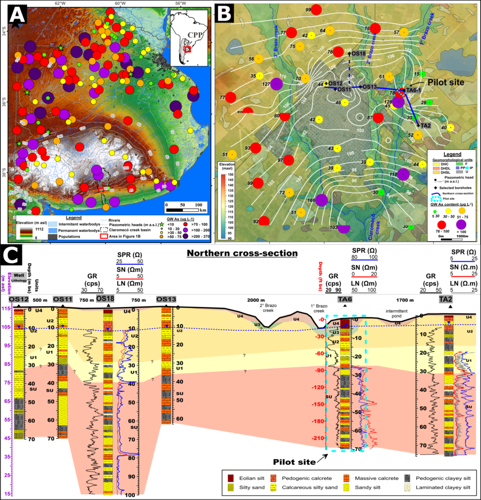
Figure 1. A) Piezometric head and groundwater As content in Pampean Plain (A) and surveyed area (B) (Auge et al., 2013; Sierra et al., 2021) indicating pilot area (B and C). B) Pilot site in the surveyed area with geomorphic units described in the text. C). Hydrogeological cross-section based on TA6-1 and reference boreholes including: lithology and geophysical logging: long and short resistivity (LN and SN, [Ω-m]), single punctual resistance (SPR, [Ω]) and gamma-ray (GR, [cps]).
Methods
A pilot site (1 km2) (−38.367°, −60.246°) (Figure 1C) was established based on a previously surveyed study area (100 km2) (Figure 1B). A 70 m (220 ft) depth exploratory borehole (TA6-1) was carried out in a productive section of the multilayer Pampean aquifer for sedimentary sampling/analysis and geophysical borehole logging. Two Electrical Resistivity Tomography (ERT8 and ERT9) profiles were acquired, and five piezometers (TA6-2 to TA6-5) were carried out with short-screen (1-2 m) at ERT-relevant depths 6, 13, 35, 65 m below surface (bs) for groundwater analysis (Figure 3).
The TA6-1 borehole (Ø 8″) was carried out by percussion drilling without drilling fluids to avoid contamination and sampling (each 1 m advance) for bailed water samples (for major elements) and detritus/core samples for selected laboratory analyses: bulk/clay’s X-ray diffraction (XRD (N= 67)), petrographic thin-sections (N = 15), particle size distribution (N = 30) elemental analysis by ICP-MS based on aqua regia (AR) acid digestion (1:1:1, HCl:HNO3:H2O) on high mass samples (15 g).
The geophysical logging system included Micrologger® (by Robertson Geologging, Inc.) with electric and NGS probes (Robertson Geologging, 2011). The former was logged at 3 m min-1 in uncased condition after drilling, and three electrical arrays were considered: specific punctual resistance (ρSPR) and 16″ short-normal (ρSN), and 64″ long-normal resistivity (ρLN). The NGS probe, a large-volume NaI crystal-scintillator, records GR activity from rock-forming elements (or decay series): 40K, 232Th (208Tl), and 238U (214Bi) (Killeen et al., 2015) calculating K (%), Th and U (mg kg-1) contents and respective errors (eK, eTh, and eU) by Full Spectrum Analysis (Robertson Geologging, 2011). The NGS probe was logged with PVC casing (Ø 5″, 4 mm wall thickness) to minimize GR contamination without drilling mud, gravel pack, cementation, or man-made isotopes. Two acquisition modes were applied: continuous (NGSC) and punctual (NGSP). The NGSC is a real-time depth log at slow speed (1 m min-1) with a 10 mm sample interval post-processed with a 1 m moving average. On the other hand, the NGSP log registers a time log (1 min) at regular intervals (3 m-1) in agreement with a radius of investigation (0.30 m) (Killeen et al., 2015). Finally, NGSP data were averaged at a 1 m interval to coincide with AR-ICP analysis.
The ERT profiles were acquired, including TA6-1 location at perpendicular orientations and considering measured groundwater flow paths to investigate subsurface heterogeneity. A SuperSting R1/IP® Resistivity meter (by Advanced Geosciences, Inc.) was used with 56 electrodes placed 5 m apart (275 m). Electrical resistivity data were collected with the Dipole-Dipole (DD) and Schlumberger (SCH) electrode arrays. The former better resolves lateral changes in true resistivity (ρ), that is, loess-type sediments vertical variations. The selected electrode array reached an appropriate depth of investigation of ~65 m bs (213 ft bs). Field apparent resistivity (ρa) raw data were inverted using the EarthImager 2D software® (by Advanced Geosciences, Inc.) for excluding data errors, topographic correction, and inversion by smooth method, based on minimal ρchanges frequent in homogeneous sedimentary sequences, considering RMS (root-mean-square) error (<10) % and L2-norm (<3 %) (Advanced Geosciences, 2009).
Borehole lithology and NGS logging
Five lithological units (U) were differentiated in the TA6 borehole based on sedimentary logging/analysis and upwardly named: subsurface unit (SU), U1, and U2 units integrate Neogene substrate and host the multilayer Pampean aquifer. The overlaying U3 and U4 units are Quaternary infills hosting the phreatic Post-Pampean aquifer. The U1 to U4 units agree with the existing regional stratigraphic framework (Sosa et al., 2019), whereas the SU unit is a non-outcropping, previously unmentioned unit. The petrographic and mineralogical analyses revealed homogeneous mineral components prevailing: quartz (Qz), plagioclase (Pl), VGS, and K-feldspar (KF) (Figure 2). Clays and minor minerals vary according to each unit and lithology: illite (I), smectite (S), calcite (Cal), zeolites (Zeo), crystalline/amorphous Fe-Mn-(oxy)hydroxides (Ox) (Figure 2) and apatite (not shown).
The AR extracts, similarly to the acid-oxalate digestion method, include mobile fractions (water-soluble minerals, adsorbed/interchangeable ions, carbonates, and Fe-Mn-(oxy)hydroxides); consequently, they were considered. As content ranged between 3.5 and 6.3 mg kg-1 increasing from massive calcrete (SU), silty sands (U1), pedogenic calcretes (U3), and pedogenic clayey silts (SU) enriched with crystalline Fe-Mn-(oxy)hydroxides indicated as a (Figure 2). Moreover, As content has significant (p <0.01) positive correlation (Pearson’s coefficient) with clay and fine silt fractions (r = 0.66) and with AR-extract’s elements: Fe2O3 (r = 0.57), MnO (r =0.54), Al2O3 (r = 0.55) and ThICP (r = 0.57) probably related to crystalline and amorphous Fe-Mn-(oxy)hydroxides and to low crystallinity clay minerals prevailing in SU unit. However, these correlations are improved by excluding four calcitic samples in U3 (7 and 9 m bs) and U2 (12 and 17) with calcretes with intermediate As indicating a potential As sink in calcretes (Figure 2). Relative immobile ThICP has a high positive correlation with Fe2O3 and MnO and Al2O3 (r = 0.91, both), indicating their association (oxy)hydroxides and low crystallinity clays in paleosoil horizons in SU unit and discrete layers in U1 and U2 units (Figure 2). However, As intermediate to high positive correlation with K2OICP (r = 0.44) and UICP (r = 0.76) is probably related to mentioned minerals but with lower representation due to silicate’s incomplete digestion by the AR method. In addition, VGS associated with zeolites were also recognized mainly in U4 and SU units.
The recognized Neogene units (SU, U1, and U2) are laterally extensive (Figure 1C), hosting a multilayer Pampean aquifer. The US is characterized by As-rich pedogenic clayey silts, enriched with S and Ox, as nodules and coatings, interbedded with discrete massive matrix-calcretes with intermediate As content. These lithologies correlate fairly with Fe2O3, MnO, ThICP contents (Figure 2), and other elements (e.g., Al2O3). Moreover, the GR log identifies intermediate activities (c. 75 cps) and low ρLN disrupted by higher ρSN in calcrete layers. Notwithstanding this, KNGS and ThNGS logs allow identifying VGS-rich beds (↑KNGS, ↓Th/KNGS) and paleosoils (↑ThNGS, ↑Th/KNGS) (Figure 2). Calcitic matrix-supported conglomerates and sands characterize the U1 and U2 composed of basal quarzitic fine sands and intermediate As microcrystalline calcretes (Figure 2) favor diluent GR activities (c. 30-70 cps) and ↑Th/KNGS ratio.
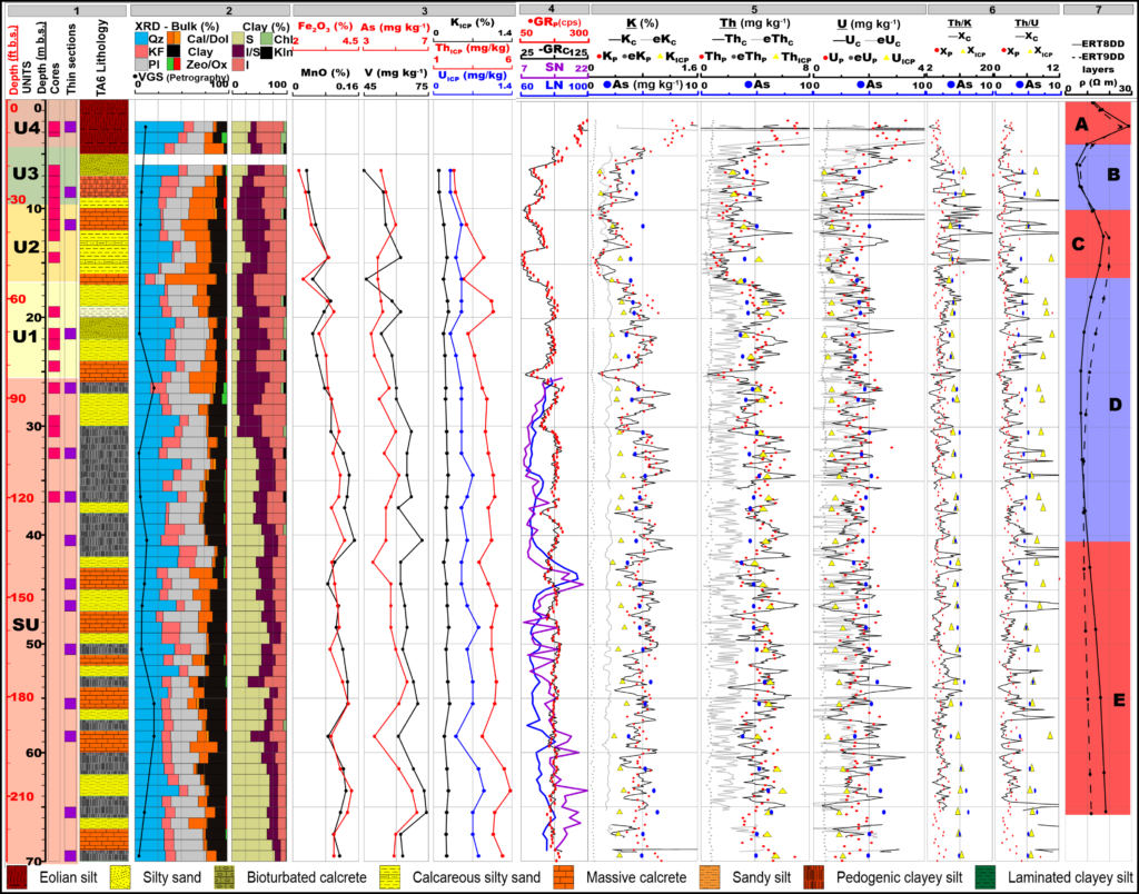
Figure 2. The TA6 sedimentary (Tracks 1 to 3), and geophysical logs (4 to 6) and ERT resistivity profiles (7). Track 1: lithology, units (US, U1 to U4), and cores/thins sections log. Track 2: stacked bar with XRD mineralogy (bulk and clay fractions) and overlapping VGS content. Track 3: Elemental logs: Fe2O3, MnO, As and V, K2O, Th, and U. Track 4: The electrical logs (GR, LN, and SN). Track 5: NGS logs include GR and elemental logs (K, Th, and U) acquired by continuous (C) and punctual modes (P) with respective errors (e). Track 6: NGS log-ratios. Track 7: Resistivity logs and layers (A to E) extracted from ERT8 and ERT9 at TA6 borehole location.
The Quaternary units (U3 and U4) are localized in low-lying areas such as linear alluvial plains (U3) and deflation hollows (U4) hosting phreatic Post-Pampean aquifer. The U3 is composed of fluvial arkosic, very fine sands with abundant calcite and fibrous gypsum (Figure 2), diluent GR activities (27-70 cps) mainly recognized by ↓KNGS and ↑UNGS. On the other hand, U4 is characterized by well-sorted sandy coarse silts with abundant fresh VGS and zeolites (Figure 2. Moreover, this unit shows the highest GR activities (70-140 cps) and, consequently, K, Th, and U contents indicated by NGS logs (Figure 2).
The NGSC dataset (N = 6198) is plotted in Track 5 in Figure 2, including GRC log, content logs (KC, ThC, and UC) in black lines, and error content logs (eKC, eThC, and eUC) in gray lines. A high average error is recognized in the complete dataset for eKC (0.29 %), eThC (1.87 mg kg-1) and eUC logs (1.09 mg kg-1). The GRC log has a significantly high positive correlation with the KC log (r = 0.80), but the non-representative low correlation with ThC (r = 0.33) and UC (r = 0.17) is probably related to limited acquisition time (Killeen et al., 2015) limiting absolute relation with ICP contents. Despite this, the NGSC log has a similar depth pattern to the NGSP log (plotted as red dots), indicating a potential application as an expedited fast exploratory log with greater utility than the classic total GR log.
The NGSP dataset (N = 242) was averaged to 1 m depth interval (N = 67) towards correlation purpose. GRP log shows a significant positive correlation between KP (r = 0.94) and ThP (r = 0.90) similar to other radiometric surveys in continental sequences (Svendsen et al., 2007) and indicating common mineral associations. However, lower correlation with UP (r = 0.70) and low correlation between UP and KP (r = 0.47) and ThP (r = 0.35) indicate separate mineral sources.
The correlation between 1 m averaged NGSP and ICP datasets (N= 30) show K and Th contents shows intermediate positive correlation (r = 0.57, r = 0.59 respectively), improved by excluding an outlier (15 m) (r = 0.78, r = 0.74 respectively) probably due to AR incomplete extraction. However, U has a low positive correlation with K and Th (r 0.22, r 0.14 respectively) probable AR incomplete digestion of silicate phases and different volume samples by AR digestion (15 g) and NGS logging (~150 Kg).
Lateral variations in the ERT Surveys
The measured electrical resistivities (ρ) along the ERT8 and ERT9 transects reveal five distinct horizontal layers, downwardly named layer A (vadose zone) and B to E layers (Pampean aquifer) (Figures 2 and 3). The ρ values in layers agree well with sedimentary and geophysical logs in TA6-1 borehole and groundwater electrical conductivity (EC) in sampled piezometers (Figures 2 and 3). Moreover, acceptable low error indicator (RMS, L2-norm) (Advanced Geosciences, 2009) were calculated for ERT8-S (1.95%, 0.42), ERT9-S (1.91%, 0.41), ERT8-DD (6.83%, 1.61) and ERT9-DD (9.00%, 5.97).
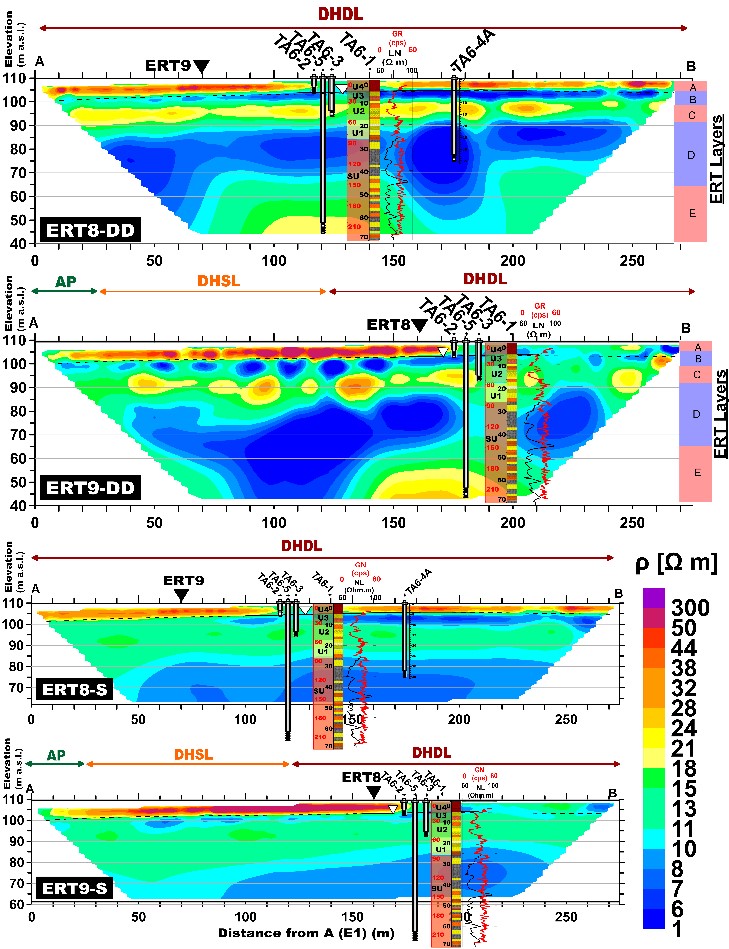
Figure 3.Perpendicular ERT8 and ERT9 resistivity sections, with DD and SCH arrays, intersected at ▼. Five resistivity layers (A to E) are indicated. Exploratory borehole (TA6-1) and four piezometers (2 to 5) with groundwater levels are indicated. TA6-1 includes lithological units and geophysical logs (GR and LN).
The ERT8-S and ERT9-S clearly discretized horizontal configuration in A to D layers up to 43 m bs due to method limitation in the depth of investigation (Figure 3). On the other hand, ERT8-DD and ERT9-DD improved vertical heterogeneity discretization in A to E layers up to 65 m bs. The ρ in both ERT8-DD and ERT9-DD profiles ranged between 2 and 224 Ω-m, and the average ρ value is 13 ± 8.9 Ω m. The ρ in the resistive A layer, considering the ERT8-DD profile, is 23.5 ± 12.6 Ω m (4.8-150.3 Ω m) with a base corresponding with groundwater level (4.5 m bs) (Figure 3) and coinciding with VGS-rich sandy loess in U4 unit. The conductive B layer, up to 10 m bs, is characterized by an average ρ value of 11.2 ± 4.2 Ω m (4.6-30.1 Ω m), in agreement with calcitic sands in the U3 unit (Figure 2) hosting shallow brackish groundwaters with highest groundwater EC values measured at similar depths: TA6-1 bailed sample (7,540 μS cm-1) and TA6-2 pumped sample (3,910 μS cm-1) (Figure 3). The average ρ in the resistive C layer, up to 17 m bs, was 16.7 ± 4 Ω m (4.6-30.1 Ω m) in agreement with EC (2,480 μS cm-1) in the TA6-3 sample and lithology in U1 and U2 units (Figure 2) composed by calcitic matrix-supported conglomerates and microcrystalline sandy calcrete layers respectively. Interestingly, the downhill thickness of layer C increases toward lower horizontal coordinates in ERT8 and ERT9 profiles. This thickness increases in layer C toward Claromecó creek’s affluent (Figures 1C and 3) in agreement with the fluvial origin of U1 and U2 units.
The conductive layer D and resistive layer E (Figure 3) agree to be acceptable with the clayey upper section and loess/calcrete intercalation in the SU unit’s lower section, respectively. Moreover, these layers agree with similar groundwater EC in TA6-4 and TA6-5 samples (2014 and 2480 μS cm-1). The average ρ in layer D was 7.8 ± 1.5 Ω m (3.7-15.0 Ω m), mainly related to pedogenic clayey silts in the upper section of the US unit. On the other hand, the average ρ in layer E was 13 ± 2.7 Ω m (8.8-22.5 Ω m), in agreement with the lower section in the US unit composed of an alternation of sandy loess and lateral extensive discrete calcretes. Moreover, a greater definition of heterogeneity and limits between D and E layers was obtained with electrical borehole logs than with the total GR log (Figures 2 and 3). The SN and LN logs clearly differentiated a resistive discrete extensive calcrete layer (c. 45 m bs) between the D and E layers. Moreover, the SN log clearly differentiated downward loess and calcrete intercalation (Figure 2).
Conclusions
Electrical resistivity tomography and total GR geophysical logging distinguished the main lithologies, and the lateral variability of recognized units supported a multi-proxy sedimentary dataset that correlates with neighboring boreholes. NGS logging is a field expedite fast exploratory log (NGSC) and interest interval log (NGSP) that supports the identification of As-rich minerals and lithologies: VGS (↑KNGS and ↓ThNGS/KNGS), Fe-Mn-(oxy)hydroxides (↑ThNGS) and calcite (↑ThNGS/KNGS). The ERT identified five layers and their vertical heterogeneity and agreed with lithology, recognized units, and groundwater EC in piezometers. Improved geophysical site characterization with NGSC and NGSP logging supports the development of a hydrogeological conceptual model with a detailed sedimentary component oriented to As sources/sinks identification. This approach can be extrapolated to similar nearby areas to support future mitigation strategies.
Acknowledgments
Funding projects: PICT (1805/2014, 4422/2019) and PID (0075/2011) (ANPCyT). We are grateful to Dr. D. Poiré (CIG) for XRD’s analysis, landowners, IHLLA’s technicians, Tres Arroyos city’s government, and Plusagua Inc. for sharing logs.
References
Advanced Geosciences, Inc. 2009. Earth Imager 2D, resistivity and IP inversion software, version 2.4.4.649. Instruction’s manual. Austin, EEUU. 94 pp.
Auge, M., Espinosa-Viale, G., and Sierra, L., 2013, Arsénico en el agua subterránea de la provincia de Buenos Aires. In: González, et al. (Eds.). VIII Congreso Argentino de Hidrogeología. La Plata. II: 58–63. https://doi.org/10.13140/RG.2.1.3333.4245
Börker, J., Hartmann, J., Amann, T., Romero‐Mujalli, G., Moosdorf, N., and Jenkins, C., 2020, Chemical weathering of loess and its contribution to global alkalinity fluxes to the coastal zone during the Last Glacial Maximum, Mid‐Holocene, and Present. Geochem. Geophys., v. 21 no. 7, e2020GC008922. https://doi.org/10.1029/2020GC008922
Bundschuh, J., Armienta, M., Morales-Simfors, N., Alam, M., López, D., Delgado Quezada, V., … and Ahmad, A., 2020, Arsenic in Latin America: New findings on source, mobilization, and mobility in human environments in 20 countries based on decadal research 2010-2020. Crit. Rev. Env. Sci. Tec. 51(16), 1-139. https://doi.org/10.1080/10643389.2020.1770527
Dietrich, S., Bea, S., Weinzettel, P., Torres, E., and Ayora, C., 2016. Occurrence and distribution of arsenic in the sediments of a carbonate-rich unsaturated zone. Environmental Earth Sciences, 75(2), 1-14. https://doi.org/10.1007/s12665-015-4892-7
Guérin, R., 2005, Borehole, and surface-based hydrogeophysics. Hydrogeology Journal, 13(1), 251-254. https://doi.org/10.1007/s10040-004-0415-4
Jamil, N., Feng, H., Ahmed, K., Choudhury, I., and van Geen, A., 2019, Effectiveness of Different Approaches to Arsenic Mitigation over 18 Years in Araihazar, Bangladesh: Implications for National Policy. Environ. Sci. Technol., 53(10), 5596-5604. https://doi.org/10.1021/acs.est.9b01375
Killeen, P., Mwenifumbo, C., and Ford, K., 2015, Tools, and Techniques: Radiometric Methods. In: Treatise on Geophysics. Elsevier BV 11, 547-524. https://doi.org/10.1016/B978-0-444-53802-4.00209-8
Podgorski, J., and Berg, M., 2020, Global threat of arsenic in groundwater. Science, 368(6493), 845-850. https://doi.org/10.1126/science.aba1510
Polya, D., Sparrenbom, C., Datta, S., and Guo, H., 2019, Groundwater arsenic biogeochemistry – key questions and use of tracers to understand arsenic-prone groundwater systems. Geosci. Front. 10, 1635–1641. https://doi.org/10.1016/j.gsf.2019.05.004
Richards, L., Magnone, D., Sovann, C., Uhlemann, S., Kuras, O., van Dongen, B., Ballentine, C., and Polya, D., 2017, High resolution profile of inorganic aqueous geochemistry and key redox zones in an arsenic bearing aquifer in Cambodia. Sci. Total Environ. 590: 540–553. https://doi.org/10.1016/j.scitotenv.2017.02.217
Robertson Geologging. 2011. WinLogger Software Operating Manual, V1.4.9.494.
Scanlon, B., Nicot, J., Reedy, R., Kurtzman, D., Mukherjee, A., and Nordstrom, D., 2009, Elevated naturally occurring arsenic in a semiarid oxidizing system, Southern High Plains aquifer, Texas, USA. Appl. Geochem. 24: 2061–2071. https://doi.org/10.1016/j.apgeochem.2009.08.004
Sierra, L., Weinzettel, P., Dietrich, S., Bea, S., Kruse, E., Richards, L., Pincetti, G., and Polya D., 2021, Geologic/Geomorphic controls on groundwater arsenic occurrence in a loess-type aquifer in southern Pampean plain, Argentina. 8th International Congress of Arsenic in the Environment As2020. Wageningen, Netherlands. 2 p.
Sosa, N., Kulkarni, H., Datta, S., Beilinson, E., Porfido, C., Spagnuolo, M., and Surber, J., 2019, occurrence and distribution of high arsenic in sediments and groundwater of the Claromecó fluvial basin, southern Pampean plain (Argentina). Sci. Tot. Env., 695, 133673. https://doi.org/10.1016/j.scitotenv.2019.133673
Svendsen, J., Friis, H., Stollhofen, H., and Hartley, N., 2007, Facies discrimination in a mixed fluvio-eolian setting using elemental whole-rock geochemistry—applications for reservoir characterization. Journal of Sedimentary Research, 77(1), 23-33. https://doi.org/10.2110/jsr.2007.008
Uhlemann, S., Kuras, O., Richards, L.A., Naden, E., and Polya, DA, 2017, Electrical resistivity tomography determines the spatial distribution of clay layer thickness and aquifer vulnerability, Kandal Province, Cambodia. J. Asian Earth Sci. 147: 402–414. https://doi.org/10.1016/j.jseaes.2017.07.043
Author Bios
Leonardo Sierra recently finished a Ph.D. in Geological Sciences at UNC (Córdoba, Argentina). For the last two years, he has been working as a Postdoc fellow at IHLLA Institute, specializing in the innovative research-oriented borehole and surface geophysical methods and subsurface hydrology and environmental and contamination assessment. Leonardo’s work focuses on integrated aquifers characterization by borehole direct and surface/borehole geophysical methods and previous five years of experience in hydrogeological and remediation studies. lsierra@ihlla.org.ar

He earned his Ph.D. in Geology from the Universidad Nacional del Sur (Bahía Blanca, Argentina). He is an independent researcher of the Scientific Research Commission of the Buenos Aires province (CIC). Adjunct professor of the Faculty of Agronomy of the Universidad Nacional del Centro de la Provincia de Buenos Aires (UNICEN). He has carried out research on the hydrodynamics of the unsaturated zone in plain areas with the application of DC resistivity methods. He currently works on hydrogeophysics and aquifers exploration to obtain low-As groundwaters. He has published scientific papers on these topics and has supervised research projects and human resources training. paw@ihlla.org.ar
After his doctoral degree, his research focused on the hydrogeology and hydrogeochemistry of shallow groundwaters in flatland environments, using laboratory experiments, hydrochemical information, and modeling techniques combined with near-surface geophysics. In the last two years, geochemical investigations were strengthened with isotopic tools, which led to the study of the origin of different water types. He is also participating in an institutional research project studying the connectivity between surface water and groundwater using hydraulic, hydrochemical, and isotopic methods. sebadietrich@ihlla.org.ar
He earned his Ph.D. in Geology from the Universidad Politécnica de Cataluña (Barcelano, Spain). He is an independent researcher of the National Scientific and Technical Research Council (CONICET). He has researched the reactive transport modeling of relevant elements: Cr, As, and Li. He has published scientific papers on these topics and has supervised research projects and human resources training.sabea@ihlla.org.ar
Soledad earned her BSc in Geology from the National University of Río Cuarto (Argentina). She has a doctoral fellowship, and she is currently conducting her doctoral career in Applied Sciences on Health and Environment at IHLLA Institute. Soledad’s dissertation focuses on the occurrence of Arsenic and Fluoride in the groundwater of the Pampeano Aquifer in Argentina. Soledad is expanding on her training in isotopic and hydrogeochemistry techniques better to understand groundwater flow paths and the water age and to know more about the mobility of As and F and their geogenic sources. msgualde@ihlla.org.ar
