
By : Jack Montgomery, Brannon McDonald, Kaye Chancellor Davis, Michael Kiernan, and Dan Jackson
Published: 07/05/ 2021
The Alabama Department of Transportation and Auburn University have partnered to integrate geophysics into geotechnical investigations along Alabama highways. This partnership began in 2017 with a research project through the Auburn University Highway Research Center to examine surface-based geophysical methods that could be used to evaluate sinkholes along Alabama highways (Montgomery et al. 2020, Kiernan et al. 2021) and has expanded to include landslide investigations and bridge foundations. This article describes the development of ALDOT’s geophysical program and presents results from surveys performed by Auburn researchers and ALDOT geologists at landslide and sinkhole sites.
Developing a Geophysics Program for ALDOT
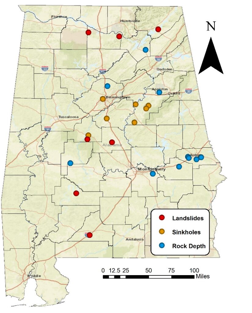
Prior to 2017, ALDOT had little experience using geophysical methods for geotechnical investigations. This was primarily due to the cost of obtaining the equipment and the unfamiliarity of ALDOT engineers and geologists with where to apply the methods and how to interpret the results (based on survey results from Rosenblad and Boekmann 2020). ALDOT recognized the potential benefits of integrating geophysical methods into their investigations and began a research program with Auburn University (AU) to help develop in-house expertise with applied geophysical methods to highway projects. The initial partnership between ALDOT and AU focused primarily on sinkhole investigations. Large portions of north and central Alabama are underlain by karstic rocks and sinkholes along highways have led to both significant traffic disruptions and large repair costs (e.g., Orange and Smith 2014). Sinkhole investigations commonly utilize a dense grid of borings to establish the location of voids or soft zones in the soil and to map the rock surface. The collection of enough discrete data to complete this mapping is both expensive and time-consuming. Integrating surface-based geophysical methods into ALDOT’s sinkhole investigation program was identified as a way to both reduce costs and increase the reliability of the data. Montgomery et al. (2020) documented geophysical surveys performed at eight sites around Alabama (Figure 2) with either active (open) sinkholes, repaired sinkholes, or karst bedrock leading to subsidence. Through this study, ALDOT personnel and AU researchers acquired the equipment and training to perform electrical resistivity tomography (ERT), multichannel analysis of surface waves (MASW), and seismic full waveform inversion (FWI) surveys. A new seismic FWI program was developed through this work (Jackson and Montgomery 2021) and Kiernan et al. (2021) performed a detailed comparison of ERT and FWI results at one of the sites. A case study from surveys performed at the site of a repaired sinkhole near Centreville, AL is discussed below.
ALDOT’s geophysical program was expanded beyond sinkhole investigations as part of the Federal Highway Administration (FHWA) Every Day Counts initiative, Advanced Geotechnical Methods in Exploration (A-GaME). The ALDOT Materials and Test Bureau established an advisory team with representatives from ALDOT, FHWA, a local geotechnical firm, and AU. The purpose of the advisory team was to identify ways to improve ALDOT’s geotechnical investigations and provide guidance on how to implement new technologies into current practice. The team focused primarily on cone penetration tests (CPTs) and ERT for use in landslide investigations and design of bridge foundations. The team is currently looking into measurement while drilling (MWD) technologies that can be added to ALDOT’s drill rigs. The advisory team has been able to bring together individuals with a variety of perspectives and backgrounds to identify effective ways to integrate both geophysics and CPTs into ALDOT’s geotechnical program.
Lessons Learned from Geophysical Surveys along Alabama Highways
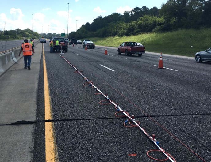
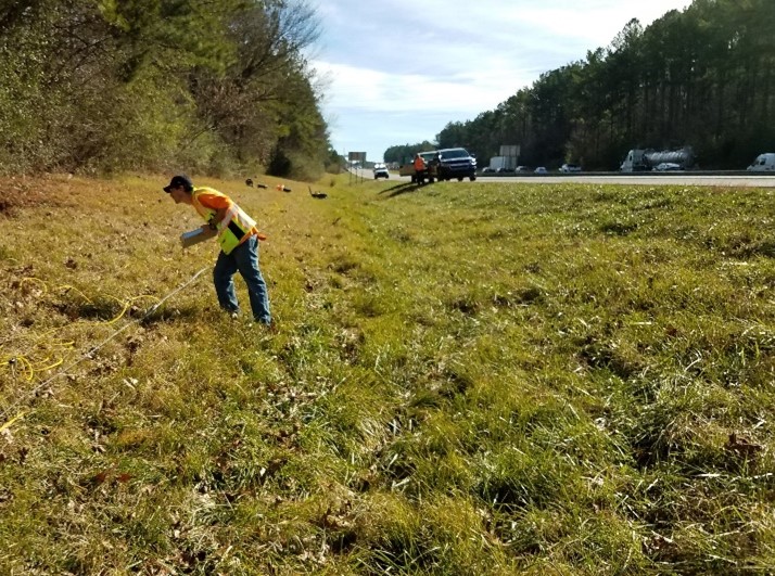
AU researchers and ALDOT personnel have partnered to perform electrical resistivity and seismic surveys at more than 25 locations across the state during the past three years (Figure 2). These surveys have focused on characterizing sites with potential or confirmed sinkholes or landslides, or mapping bedrock surfaces for bridge foundation designs. Electrical resistivity surveys were performed using an 8-channel AGI SuperSting with either 56 or 112 electrodes and primarily used a combination of dipole-dipole and strong gradient arrays. Seismic surveys were performed using two 24-channel Geode seismographs. The seismic surveys have primarily focused on measuring surface waves generated using either a 10- or 20-lb sledgehammer and recorded using 4.5 Hz geophones. A land streamer (Figure 1) has been successfully used with the geophones at several sites where long surveys were needed or surveys were performed on paved surfaces.
Seismic data has been primarily interpreted using MASW for establishing 1D profiles at landslide sites and bridge foundation investigations, while FWI has been used at sinkhole sites where the presence of voids or other heterogenous conditions might affect the MASW interpretation. The active seismic surveys have generally been limited to depths of about 35 feet, while passive MASW surveys have been used at selected sites to establish deeper profiles. Resistivity testing has primarily focused on ERT to map stratigraphy and locate anomalies that might indicate presence of voids or irregular bedrock surfaces. The maximum depth of investigation for the ERT surveys has been approximately 200 feet, but this is limited by the selected survey length.
Overall, both methods have performed well in a variety of geologic conditions; however, performing surveys along busy highways presents several challenges. Metallic infrastructure, such as buried utilities and overhead power lines, are commonly found along highways and can affect ERT results. To mitigate this issue, the locations of survey lines are selected to try to avoid potential interference. Results are also checked during the inversion process to try to identify any indications of offline interference. Traffic noise from large trucks has been an issue for some of the seismic tests and the survey team attempts to select relatively quiet periods between trucks to take shots in order to reduce this noise. Topography is also a common challenge as surveys are typically performed along the shoulders where slopes may be steep or irregular. In areas with appreciable elevation change along the survey line, topographic surveys are performed along each line using a total station. Coordinates of borings, survey markers, utilities, and other prominent features are also collected to create site maps and tie the line location into a known coordinate system. Drones (UAVs) have also been used to create terrain maps at some sites.
Case Study 1: Landslide on US-231 near Lacey’s Springs, AL
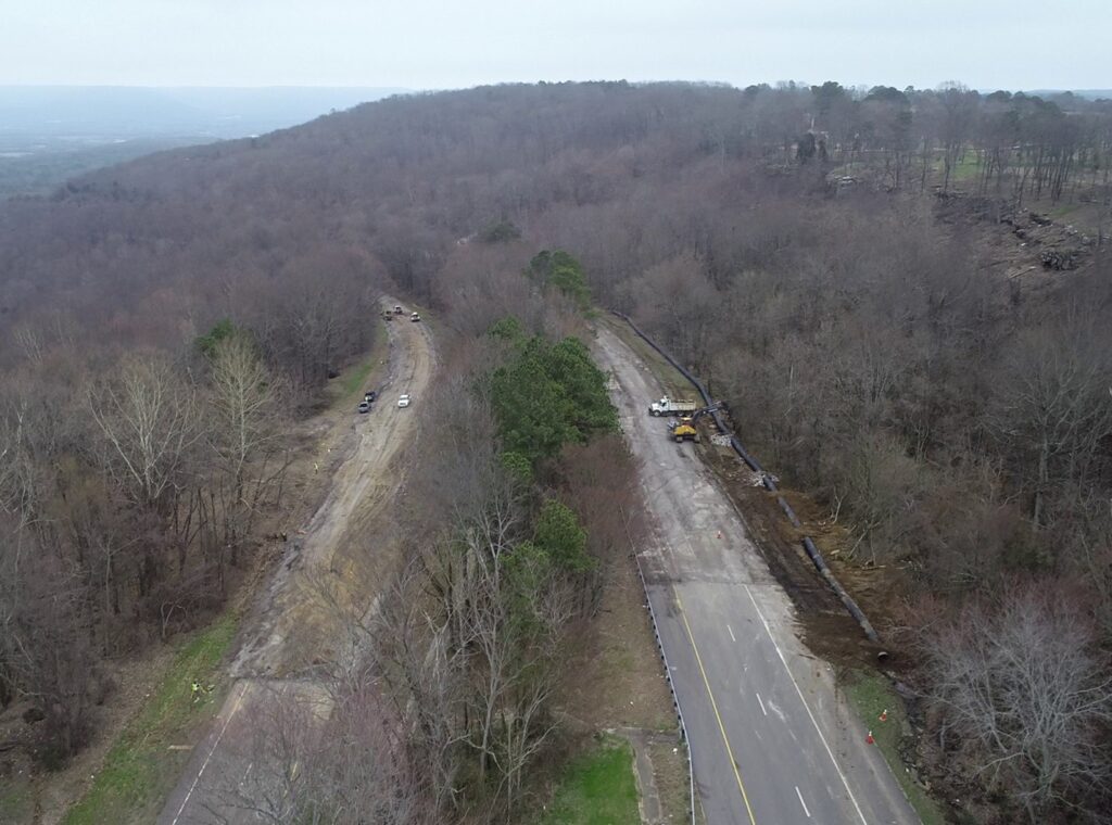
A large landslide occurred on US-231 near Lacey’s Springs, AL on February 13, 2020 following a period of heavy rainfall. The section of highway is a heavily used corridor for Huntsville commuters and closures due to the slide added 30 to 60 minutes to commute times for local residents. This section of highway was likely constructed on an ancient landslide and had a history of movement. Following heavy rain in February 2019, ALDOT drilled five borings and installed inclinometers to monitor slope movement. The rate of movement increased following large storms in December 2019 and culminated in the failure of both north and southbound roadway lanes on February 13th (Figure 3). On February 14th, Auburn researchers and ALDOT personnel met on the site and seismic and resistivity tests were performed the following week to better understand the stratigraphy and plan for a larger exploration program. The consulting firm Dan Brown and Associates was brought in to assist with the full investigation and design the repair (two bridges with large diameter drilled shaft foundation). Details of the repair are provided by Thompson and Dapp (2021).
Borings performed at the site generally show an upper layer of interbedded sand and clay or sandstone and clay, followed by an interbedded clay, mudstone and limestone. The majority of the site is located within the outcrop area of the Pennington Formation, which consists of medium-gray shale, containing interbedded limestone, dolomite, argillaceous sandstone, mudstone, and minor shaly coal (Szabo et al. 1988). Interbedded mudstone and limestone were encountered in all borings at elevations ranging from about 1082 feet to 1087 feet. Above Pennington Formation bedrock, borings showed a mix of fill and colluvium, although it was difficult to identify a clear boundary between these. The inclinometers showed movements were primarily to the north – northwest, as indicated by the crack orientations in Figure 4, and at elevations of about 1090-1086 feet in B-2 and about 1094-1088 feet in B-3.
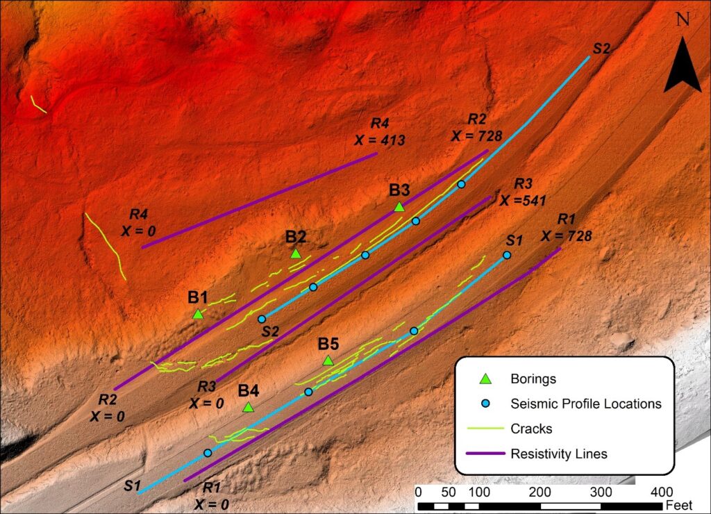
Electrical resistivity and seismic surveys were performed between February 17th and February 20th, 2020 (Figure 4). Four electrical resistivity surveys (R1-R4) were performed using strong gradient arrays, and inversion of the measured resistivity data was performed using the commercial software EarthImager 2D. The terrain along each survey line was incorporated into the inversions as estimated using a total station. Seismic data was collected on February 17, 2020 (S1 and S2 in Figure 4) using a set of 24 4.5-Hertz geophones connected to a Geometrics Geode seismogram. A 20-pound sledgehammer was used as the source for all lines. A geophone spacing of 6.6 feet (2 meter) was used for both lines. The geophones were placed on a land streamer that was towed behind a truck, allowed the geophones to be moved easily. The sources were located 65.6 feet (20 meters) from the first and last geophone. The seismic data was processed using the multichannel analysis of surface waves (MASW) technique. The open-source software Geopsy (Wathelet et al. 2004, Wathelet 2008) was used to create the velocity-frequency images, pick the dispersion curves, and perform the inversions. The geophysical results are compared with the boring logs in Figures 5 and 6. The resistivity results were generally consistent with the borings and showed an upper zone of interbedded clay, sand, and sandstone that was generally higher resistivity underlain by lower resistivity materials that represented primarily interbedded clay, mudstone and limestone, along with some possibly saturated sandstone and clay. The higher resistivity materials are interpreted as fill and colluvium and the lower resistivity materials appear to represent the transition into the foundation materials. It is also likely that the water table was located near the bottom of the fill material, which would have contributed to the lower conductivity. Higher resistivity materials (e.g., limestone) within the foundation may be masked by the low resistivity of the upper foundation materials which were primarily clay and mudstones. The results of the seismic survey were generally consistent with the resistivity results. The seismic results in the NB lanes (Figure 5) showed a soft upper layer (approximately 3-5 feet thick), followed by a stiffer layer and transitioning into harder rock at a depth of approximately 35-40 feet. The seismic results in the SB lanes (Figure 6) also showed a soft upper layer (approximately 3-5 feet thick), followed by a stiffer layer and transitioning into harder rock at depths of approximately 24-50 feet with the rock surface becoming shallower toward the end (northeast end) of the line.
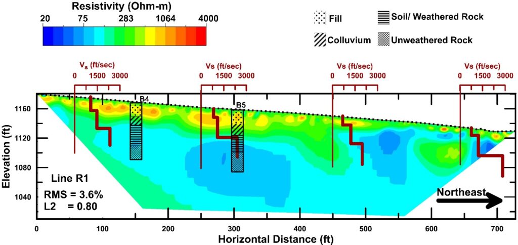
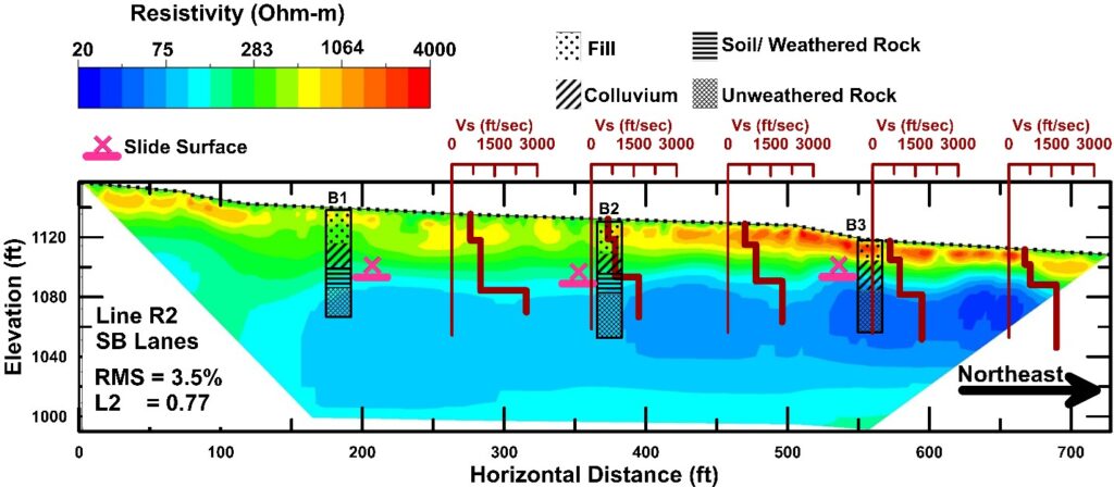
Results from both geophysical methods and the borings were integrated to identify the stratigraphy at the site. The upper 30 feet of material under both roadways was identified as fill material and colluvium (alternating sandstone and clay), while a low resistivity, low velocity zone was found at depths of 30 – 40 feet below the road. Below this layer interbedded limestone and mudstone was observed. Based on these observations and the inclinometer data, the likely source of the slide plane was a plastic clay layer found between 30 and 40 feet. Subsequent investigations were able to confirm this layer as the critical zone and characterize the underlying rock in order to design the foundations for the replacement bridge. The US-231 landslide required an “all hands on deck” approach to gather the characterization data needed to design a repair and the partnership between AU and ALDOT allowed geophysical surveys to be completed within a week of the closure.
Case Study 2: Repaired Sinkhole along Old US-82 in Centreville, AL
An electrical resistivity survey was performed along Montgomery Road (Old US-82) in Bibb County, Alabama in order to determine the depth to rock and identify any potential karst features near a repaired sinkhole. The sinkhole at this location was repaired in 2016 by excavating the loose, raveled soil and filling the hole with rip rap. Seismic surveys were not performed at this site due to the large depth to rock. The survey was performed on the north side of the road roughly centered over the sinkhole repair (Figure 7). The survey was completed approximately 10 feet off of the edge of pavement to avoid a concrete box culvert. Geologic maps of the area (Szabo et al. 1988) indicate that there are several formations containing limestone or dolostone within 2 to 5 miles of the site, although the surface geology is mapped as alluvium. At least eight sinkholes have been previously reported within a ten mile radius of the site.
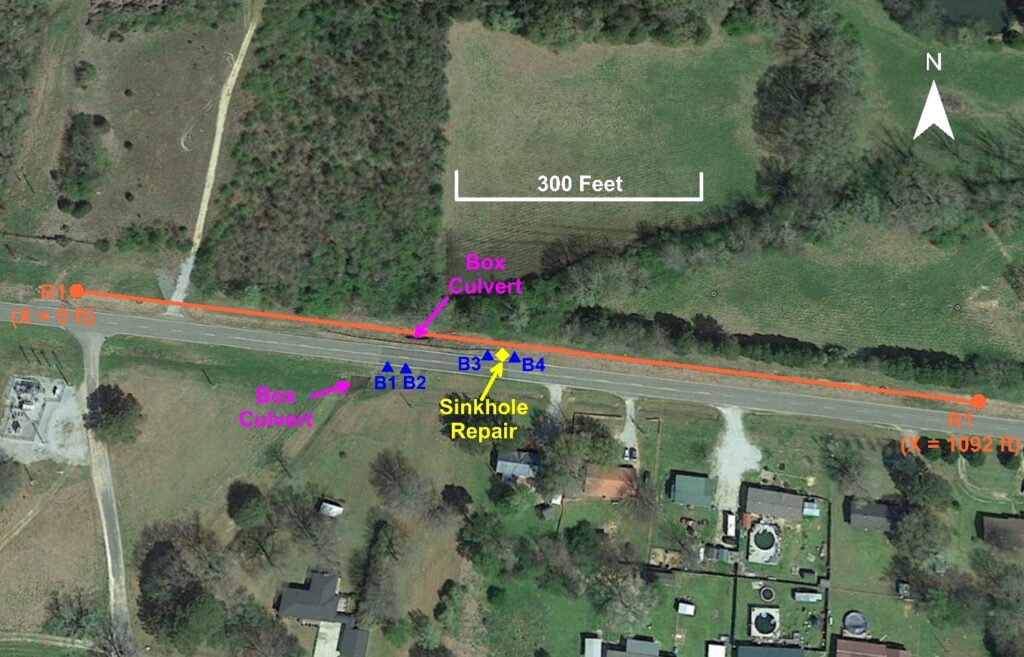
Four boreholes were drilled by ALDOT near the repaired sinkhole in 2016. Two boreholes were drilled on the south side of the road just east of a box culvert and two boreholes were drilled on the north side of the road on either side of the sinkhole repair. The exact locations of the boreholes were not surveyed, but their approximate locations are shown in Figure 7. The boreholes indicate predominantly sand with some silt, clay, and gravel to depths of 45-55 feet. These borings do not indicate depth to rock or auger refusal. Logs were also examined from two nearby municipal water wells that were drilled for the City of Centreville in 1992. The exact locations of the two wells are not known. The logs from these wells show the overburden soils consisting of sand, gravel, and clay overlying chert and limestone rock. The depth to rock was found to vary between 68-80 feet between the two well locations. One log also indicates a void present in the rock at a depth of 187 feet, which produced approximately 300 gallons per minute of water. This likely indicates a karst feature.
The interpreted results from electrical resistivity survey R1 is shown below in Figure 8. The results show a low resistivity layer (< 500 ohm-m) in the upper 40-80 feet which is interpreted as overburden soil. This upper layer is underlain by a higher resistivity layer (> 1000 ohm-m) which is interpreted as the limestone and chert rock. These depths to rock are consistent with the depths reported as part of the municipal well drilling program. The resistivity of this layer is well within the range of resistivities expected for limestone. A vertically oriented zone of high resistivity (labeled Feature 1 in Figure 8) is present directly below the location of the sinkhole repair. This feature is likely indicating the location of the sinkhole repair where the excavated hole was filled with rip rap. It may also be influenced by the presence of the culvert near the surface, although the bottom of the culvert was approximately 10 feet below the ground surface. Another feature of interest (labeled Feature 2 on Figure 8) is observed just east of Feature 1, where a vertical discontinuity in the interpreted bedrock layer is observed near X=500 feet. This feature is closely aligned with the sinkhole location and may represent the throat of the sinkhole leading into either a dip in the rock surface or potentially indicate a water filled void. Additional investigations would be needed to determine the exact nature of Feature 2 and this location should be a focus if future subsidence is noted at this site.
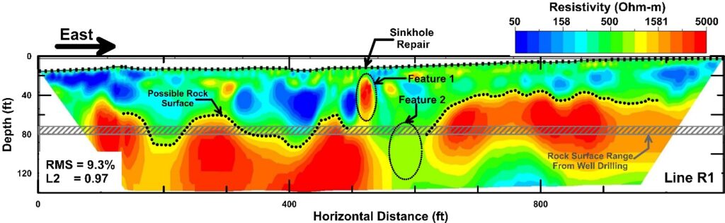
This survey illustrates one of the potential benefits of using geophysics prior to planning a drilling program. The initial drilling program at this site only sampled the alluvial materials present in the upper 50 feet of the profile and did not provide information on the underlying rock. Had the geophysical survey been performed first, the drillers would have been prepared to drill down to depths of at least 80 feet and borings could be targeted to explore the features identified in the geophysical survey (Feature 2 in Figure 8). The information from the borings could then be used to reinterpret the results of the geophysical survey and develop an integrated characterization of the site.
Summary and Conclusions
This article has summarized the development of a geophysical program for geotechnical investigations performed by ALDOT. This work began as part of a research program with AU and has now become part of the site investigation toolbox available to ALDOT engineers and geologists. As part of the FHWA A-GaME initiative, an advisory team was created to help ALDOT implement geophysical methods and CPTs into their geotechnical investigations. Over the long term, the implementation of these technologies is expected to result in improved subsurface characterizations and reduced costs by reducing the number of borings needed at a site and more resilient designs.
Geophysical methods are not expected to replace traditional borings or in-situ tests for highway projects, but they are expected to become one tool in an integrated characterization program. This type of characterization seeks to integrate the results of all available investigation methods in order to develop a ground model that honors each of the sources of data while recognizing the uncertainties present in each. For example, geophysical data can be used to quickly develop 2D or 3D profiles to develop a preliminary model of the subsurface that is consistent with the field observations and site geology. Locations for borings can then be identified based on areas of interest or greatest uncertainty in the preliminary model. The data from the borings can then be used to refine the ground model and update the interpretation of the geophysical data if needed.
Two case studies of geophysical surveys along Alabama highways were presented. In the first, geophysical methods were used to rapidly characterize the stratigraphy at a large landslide. Integrating the geophysical results with available boring logs, inclinometer data and geologic maps allowed the likely location of the failure surface to be mapped across the site. This initial characterization allowed locations for further investigations to be selected. In the second case study, electrical resistivity surveys were performed near a repaired sinkhole to map the rock surface and identify possible karst features. The resistivity surveys were able to map the rock surface at depths of 40-80 feet along a length of 800 feet. The surveys also identified a discontinuity in the interpreted rock surface in the area of the repaired sinkhole. This would be a target location for future investigation efforts. The use of FWI to investigate a sinkhole site along an Alabama highway is presented by Kiernan et al. (2021). These case studies illustrate some of the benefits of using geophysical methods in geotechnical investigations along highways.
References
Jackson, D., Montgomery, J. (2021). Formulation of an open-source seismic full waveform inversion program for geotechnical site characterization. AIMS Geosciences (under review).
Kiernan, M., Jackson, D. Montgomery, J., McDonald, B., Anderson, J. B., Davis, K. C. (2021). “Comparison of electrical resistivity and seismic surveys at sinkhole sites.” Journal of Environmental and Engineering Geophysics. 26: 1-11.
Orange, B. and Smith, D. (2014). “AL-21 Sinkhole remediation Talladega County.” 57th Annual Transportation Conference, Auburn University.
Rosenblad, B. and Boekmann, A. (2020). Advancements in Use of Geophysical Methods for Transportation Projects. Washington, DC: The National Academies Press. https://doi.org/10.17226/25809.
Szabo, M.W., Osborne, E.W., Copeland, C.W. Jr., and Neathery, T.L., (1988). Geologic Map of Alabama, Geological Survey of Alabama Special Map 220, scale 1:250,000
Thomspon, R. and Dapp, S. “Innovative Landslide Solution.” Foundation Drilling. April 2021.
Wathelet, M. (2008). “An improved neighborhood algorithm: parameter conditions and dynamic scaling.” Geophysical Research Letters, 35, L09301.
Wathelet, M., Jongmans, D., and Ohrnberger, M. (2004). “Surface wave inversion using a direct search algorithm and its application to ambient vibration measurements.” Near Surface Geophysics, 2, 211-221.
Author`s Bio

Jack Montgomery
Dr. Jack Montgomery is an Assistant Professor at Auburn University. His research and teaching primarily focus on engineering geophysics, geotechnical earthquake engineering, landslides, dams, and advanced site characterization. He received his bachelor’s degree in Civil Engineering from California Polytechnic State University, San Luis Obispo and his master’s and Ph.D. in Civil Engineering from the University of California, Davis.
Brannon McDonald
Brannon McDonald, P.G., is a chief geologist in the Materials and Test Bureau for the Alabama Department of Transportation. He received a M.S. in structural geology from Auburn University in 2000. His work experience includes environmental consulting & geotechnical applications concentrating primarily on geotechnical applications from 2007 until present. Geotechnical-related areas of experience include sinkhole and landslide remediation, soil and rock slope stability, and bridge foundation investigation for highway maintenance and construction.

Kaye Chancellor
Kaye Chancellor Davis, is the Deputy State Materials and Tests Engineer where she oversees the Geotechnical Division, Materials Division, and Pavement Management Division in the Materials and Tests Bureau. She has approximately 25 years in the Geotechnical Division of the M&T Bureau and serves as the geotechnical subject matter expert for the Department. She graduated from Auburn with a bachelor’s degree in Civil Engineering and an M.S.C.E. in Geotechnical Engineering. She serves on two national committees with the AASHTO Committee on Materials and Pavements and the Transportation Research Board. She and her husband Glen have one daughter, Sarah.

Michael Kiernan
Michael Kiernan earned his B.S. in civil engineering from UC Davis in 2015. After graduating he worked in project management for a bridge maintenance contractor for one year before leaving to pursue graduate studies at Auburn University where he is currently a graduate research assistant. His master’s thesis focused on improving numerical methods for modeling slope stability problems involving strain softening clays subjected to seismic loading. He has recently been using electrical resistivity methods to investigate sinkholes and landslides in Alabama. He plans to use electrical resistivity and numerical modeling to investigate and analyze Alabama landslides involving strain softening clays as part of his doctoral dissertation. He is a student member of the ASCE and USSD and is currently involved in creating a graduate student geotechnical society at Auburn University.

Dan Jackson
Dan Jackson is a PhD candidate specializing in geotechnical engineering at Auburn University. He has a BS and MS in civil engineering from Auburn University. He worked for a geotechnical consulting firm before returning to school for his PhD. His current research is primarily focused on site characterization and the integration of geophysical data with traditional insitu tests. He has experience in structural and geotechnical instrumentation, monitoring, and load testing.
