
Professor Nigel Cassidy
Professor of Geotechnical Infrastructure Engineering,
University of Birmingham, UK
Welcome to the 2020 Fall edition of FastTIMES infrastructure and geotechnical geophysics news; hasn’t it been a strange year?
Back in January, I opened my column looking forward to a year of new developments in software, technology and equipment not realising that it would mean going from a video conferencing dummy to a Skype-Zoom-Teams natural in less than a month – as many of us have had to. In March, I feared for the cohesion of the near-surface geophysical community as conferences, workshops and training activities were postponed indefinitely or hastily cancelled with little prospect of them being re-scheduled. Six months later, I realise my fears were ill-placed and I have attended more events on-line this summer than I would have had the funds or time to do so normally. I can choose what I attend and when (some of the technical training webinars I have attended have been excellent) and, more importantly, I can do a lot of this at my own pace and without distraction. On-line will never replace person-to-person contact, and the enjoyment we have meeting up with old friends, but it is not a bad alternative. I have ‘visited’ over twenty different countries from the comfort of my own home this summer (and at a fraction of the cost) and the interactive on-line seminars I have attended have been fantastic (and very innovative). I have been forced to be more proactively involved due to the nature of their delivery (on-line chat, audience voting, polling and live agenda-setting) and I like this. Rather than being a passive participant, as often occurs when at physical events, the audience is part of the delivery – I am definitely a convert.
On-line conferences are not for everyone but our institutions, societies and academic/industry groups have stepped up to the challenge of digital delivery and I’m pleased that they have. Maybe the unfortunate circumstances of the Pandemic forced us to rethink how we operate as a connected community and therefore foster new ways of disseminating the good work we do – I hope so. Students and career-young geophysicists from any country can now attend many more US/EU events without the crippling cost of travel and accommodation. Visa complications are not an issue and, ultimately, we have a better record of the events and their content for everyone. This cannot be a bad thing, can it?
With this all in mind, it is important to highlight two of the upcoming international events this year that have particular resonance to the infrastructure and geotechnical minded geophysicists… The SEG Annual meeting is happening between 11-16th October as a purely on-line event and, along with the usual themes, there
are a number of relatively new special sessions that have specific interest to our community including ‘Urban Geophysics’ and ‘Machine Learning in the Near Surface’. Visit https://seg.org/ am/2020/attend for more information but also have a quick read of this article in SEG’s August 2020 edition of The Leading Edge from the Chairs of the Technical committee, Olga Nedorub and Brye Swinford… “90 years of technological advancement: Envision, develop, improve, implement, teach, and envision once more” (https//doi.org/10.1190/tle39080538.1). It will certainly illustrate how societies are embracing on-line conference technology and a new future for our discipline.
The EAGE’s re-scheduled Annual Conference and Exhibition will take place in Amsterdam, 8-11th December 2020 and, although many of the sessions are being delivered physically, they will also have on-line provision. I particularly like the look of the workshops on “Passive Seismic” and “Geophysical Aspects of Smart Cites” on the 6-7th of December. Further information on the conference, and what is being delivered digitally, can be found at www.eageannual2020.org.
It is also worth looking at EAGE’s forthcoming first conference on Geophysical Monitoring Technology (GeoTech2021, The Hague, Netherlands) scheduled for the 1-3 March 2021. Although focused towards Oil & Gas technologies, there is likely to be much to offer in the way of engineering, environmental and geotechnical geophysics (including the 2nd EAGE workshop on Distributed Fibre Optic Sensing), see www.geotech.eage.org.
Conferences have always been focal events for our community and it is to the credit of the societies involved that they are developing new ways for us to be involved, particularly in the current circumstances. I look forward to seeing you there – even if only virtually.
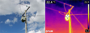
This edition of FastTIMES is very timely for me as I have been getting more involved in UAV remote sensing over the past six months. There is UAV innovation in the fields of archaeology, geoscience and environmental science that we can certainly adopt in the infrastructure sector. Geophysical techniques are at the forefront of these developments and, in combination with the more conventional drone-related imaging technologies (e.g., thermal, optical, etc), I feel there is an opportunity to expand our techniques ‘toolbox’. Thermal imaging is a good example of this and the recent purchase of a number of high- resolution thermal cameras by my University (in part as a response to Covid-19) has provided me with an opportunity to play with their capabilities. I’ve successfully used these relatively inexpensive thermal cameras for locating grout voids in cable ducts, monitoring structural defects in masonry, tracking groundwater flow and even detecting wasp nests in cavity walls. Time-lapse thermal imagery, combined with low-frequency EM sensing, has helped me track sources of electromagnetic radiation associated with potentially failing/ overloaded electricity power transformers in rural settings. It is an area of geophysics that can benefit from the experience of our engineering colleagues and I have been very impressed with the temporal response and accuracy of these instruments.
If you are curious about the possibilities of drone-based thermal imaginary, and the technology that is out there, I recommend the following places to visit… https://www.dronefly.com/blogs/news/how-thermal-drones-work/ https://www.dronezon.com/learn-about-drones-quadcopters/9-heat- vision-cameras-for-drones-and-how-thermal-imaging-works/
I have found these two sites very informative and they provide good, technical appraisals of drone-based thermal imagery and the pros/cons of current systems. The issue, as I see it, is the lack of freely available software to process and evaluate the collected images in the way that a geophysicist would require. That said, there are a number of good thermal image analysis tools available, either at cost from the thermal camera providers or as toolboxes to open-source image analysis programs. There is also a developing community of open source users who are making thermal imaging technology (mainly through Raspberry Pi and mobile phone applications) and software openly available to the hobbyist and researcher community. Have a look at… https://www.dronecode.org/ – a community site dedicated to making drone software open-source
https://www.electronics-lab.com/open-thermal-camera-thermal- imaging-rest-us/ – cheap, simple thermal camera add-ons for mobile phones
https://towardsdatascience.com/detecting-people-with-a- raspberrypi-a-thermal-camera-and-machine-learning-376d3bbcd45c – an interesting and technically comprehensive article on how to build a Raspberry Pi based thermal imaging camera.
And… this interesting, April 2020 article coming out of the Georgia Institute of Technology, Atlanta on the development of a low cost, Raspberry Pi based thermal imaging system for the auto-triage of Covid-19 patients, https://doi.org/10.1101/2020.0 4.09.20059840. What I like about the application is that it uses standard imaging components, freely available code and the combination of both optical and IR imaging in a single package whilst integrating neural network code for the automated, real- time data interpretation of data and patient screening. I can see packages like this being easily applied to the real-time monitoring of infrastructure assets and, when combined with inputs from other geophysical sensors, could lead to interesting new avenues of research for our discipline.
Finally, for this edition, I would like to share my experiences of some freely available software resources that have been very useful to me over the past few months in lockdown…
GeoPIV-RG – http://www.geopivrg.com/ – Particle Image Velocimetry program
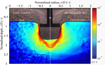
GeoPIV-RG is a free image analysis module for MATLAB users that is designed for geotechnical and structural engineering research applications. Originally developed in mid-2000s as GeoPIV, it has undergone a few revisions to get it to its current version (GeoPIV- RG). It is fantastic at tracking pixel and sub-pixel particle movement within time-lapse image sequences and colleagues of mine have been using it for soil deformation studies. There are a number of analysis/visualisation plug-ins that are very useful (e.g., small strain evaluation) but to use it properly you need to have a decent level of Matlab skill and the right version installed – it’s not quite a ‘plug and play’ application. However, once up and running, it is a powerful analysis tool that I am starting to use for applications beyond geotechnical engineering (i.e., time-lapse thermal imagery). Have a look at the “how to” videos on the site as these will give you an appreciation of its capabilities and technical requirements. There is also a very informative 2015 article from the code’s authors that can be downloaded at… https://www.nrcresearchpress. com/doi/full/10.1139/cgj-2015-0253#.X1Ynbn7lrX4 – S.A. Stanier, J. Blaber, W.A. Take, and D.J. White, 2015. Improved image-based deformation measurement for geotechnical applications Can. Geotech. J. 53: 1–13 (2016)
To help with capturing the time-lapse images/videos and sequencing them in the right format, size and duration, I have found ‘Openshot’ the most useful of the free video editing suites https://www.openshot.org/. Ultimately, it’s a matter of personal choice but I found it fairly easy to use as a beginner and the skills I have developed have been invaluable for my own on-line teaching. Colleagues also recommend ‘Blender’ (https://www.blender.org/) which appears to have more technical capabilities and high-level functions. It can also be used for particle tracking https://www. blendernation.com/2016/08/25/particle-tracking-blender/ but I suspect this is something better tackled by more advanced users.
I hope you get the chance to try out these software packages and image analysis tools and, as always, we would love to hear about your experiences. Please do send us your articles (to nigel.j.cassidy@gmail.com or the chief editor, Geoff Pettifer, editorfasttimesnewsmagazine@gmail.com) as whatever you have will be of interest to our community.
Thank you and best wishes for the Fall,
Nigel Cassidy
