
Abraham Emond
abraham.emond@alaska.gov
Welcome to this Mine Site Geophysics Special issue edition of the Government Geophysics News regular column devoted to news items from the important section of the NSG community in the Americas (US, Canada, Central and South America) working within Government, notably the Federal, State and Province Geological Surveys.
Please send me your contributions on data and report releases and either planned, upcoming, in progress or recently completed geophysical projects or research. I can be contacted at abraham. emond@alaska.gov, +1-907 451 3098 (office) or +1-801-839-4127 (cell).
Illinois State Geological Survey Geophysics Data Viewer

Over the last few years, staff and students at the Illinois State Geological Survey (ISGS) at the University of Illinois have been working to digitize an extensive archive of near-surface geophysical data. This collection, gathered from more than 90 years of data throughout the state, primarily consists of electrical and seismic surveys, downhole logs, and other geophysical data. More than a dozen geophysicists, information scientists, mapping specialists, graduate students, and undergraduate students have been involved in the effort. The purpose of this digitization project is to preserve the geophysical data for future generations and disseminate the geophysical data to potential users across the state and around the world.
More than a dozen geophysicists, information scientists, mapping specialists, graduate students, and undergraduate students have been involved in the effort. The purpose of this digitization project is to preserve the geophysical data for future generations and disseminate the geophysical data to potential users across the state and around the world.
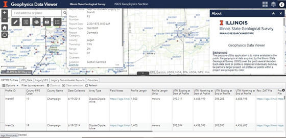
The primary output of this effort is the Geophysics Data Viewer, a map-based web portal that provides a public-facing, user- friendly interface for accessing the geophysical data collected by the ISGS. ESRI’s ArcMap Online web application tools (see screen view below) serve the data to the web portal, where the locations and data files for both historical and recent geophysical projects can be found. The portal provides plain- language explanations for each of the geophysical data types to assist viewers in understanding the data, but it also includes links to more comprehensive resources.
In order to create this online resource, team members worked on various aspects of data digitization. Thousands of hard-copy files were scanned and old hard drives (and floppy disks) were searched for missing data files that often were incompatible with current software. Templates were created for each data type to standardize data collected over several decades by several generations of geophysicists on a variety of equipment, from hand-cranked early electrical instruments and analog seismometers to the sophisticated computer-controlled systems used today. As a result, data files at various stages of processing are available for download by simply selecting any data feature on the map. Data will be continually published to the Data Viewer as it is digitized and/or collected, so periodic updates will take place.
The ISGS Geophysics Data Viewer is available at the following link: – https://prairie-research.maps.arcgis.com/apps/webappviewer/index. html?id=93e86a22e3af49fb97abfe6749bd067f
Contact: RILEY BALIKIAN, Senior Scientific Specialist Geophysics and Hydrogeology, Illinois State Geological Survey Prairie Research Institute, University of Illinois at Urbana- Champaign; 615 East Peabody Drive Champaign, IL 61820 217-300-0932 | balikian@illinois.edu; https://isgs.illinois.edu/
Saskatchewan Geophysics Data Release 2020

An airborne magnetic and electromagnetic survey was flown in the vicinity of Wapawekka Lake, Saskatchewan, from December 2019 to March 2020.
https://www.nrcan.gc.ca/nrcan/geophysics-data-release-2020/22964
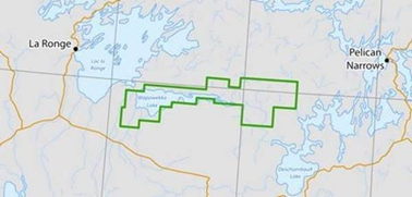
The survey was funded by the Government of Saskatchewan as part of its Mineral Development Strategy, announced in the October 2017 Speech from the Throne.
Technical support for the survey, including establishment of survey parameters and data quality assurance and quality control, was provided by the Geological Survey of Canada, Natural Resources Canada.
The data from these surveys will be used in a cooperative project including the Geological Survey of Canada and the Saskatchewan Geological Survey, and will be integrated with existing geophysics data. The survey has been flown as part of the Targeted Geoscience Initiative (TGI-5), for Volcanic and sedimentary systems volcanogenic massive sulphide ore systems.


Maps and data from the new surveys are accessible through the following links:
Maps: https://lnkd.in/gRM6gW9; https://lnkd.in/gXE6sCv; https://lnkd.in/gbd5sbN
Data: https://lnkd.in/gJ97cbk
Contact: Doug Oneschuk. Geophysicist. Airborne Geophysics Section. Geological Survey of Canada. 601 Booth Street, Ottawa, Ontario K1A 0E9. | Douglas.Oneschuk@Canada.ca
Additional Databases: Saskatchewan Geological Survey Geohub
https://geohub.saskatchewan.ca/
Reference:
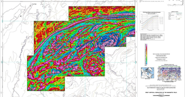
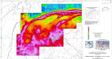
Boulanger, O; Kiss, F; Fortin, R; Mahmoodi, O, 2020 – Electromagnetic survey of the southern Glennie area, Saskatchewan, parts of NTS 73-I/16 and NTS 73-P/01. Geological Survey of Canada, Open File 8672, 2020, 9 sheets, https://doi.org/10.4095/326711 (Open Access) Example portions of the data products are shown below for the western third of the survey area – (top) 1VD magnetics; (centre) shallow-depth apparent conductivity; and (bottom) AEM mid- depth apparent conductivity.
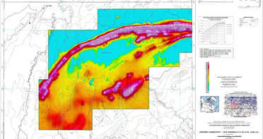
Digital versions of these maps are available for free download through GEOSCAN (http://geoscan.nrcan.gc.ca/). Corresponding digital profile and gridded data as well as similar data for adjacent airborne geophysical surveys can be downloaded, at no charge, from Natural Resources Canada’s Geoscience Data Repository for Geophysical Data at http://gdr.agg.nrcan. gc.ca/index_e.html.
