
Héctor R. Hinojosa1, Jesús Roberto Vidal Solano2, Daniel Garza Rocha3, Eduardo Rodrigues4, Adriana Hinojo5
1Cordillera Geo-Servicios, S.A. de C.V., Río Balsas # 2B, C.P. 83260, Hermosillo, Sonora, México
2Depto. de Geología, Universidad de Sonora, Blvd. Luis Encinas y Rosales s/n, Col. Centro, C.P. 83000, Hermosillo, Sonora, México
3Facultad de Ciencias de la Tierra, UANL, Carretera a Cerro Prieto Km 8, Ex. Hacienda de Guadalupe, C.P. 67700, Linares N.L., México
4Advanced Geosciences Europe (AGE) S.L., Calle del Aire, 85, 28042 Madrid, Spain
5Centro INAH, Sonora, Jesús García Final y Esteban Sarmiento s/n, Antigua Penitenciaría del Estado, Colonia La Matanza, C.P. 83080, Hermosillo, Sonora, México
Abstract
Geophysics students (undergraduate and graduate) worldwide require geophysical instrumentation (i.e., hardware and software) to apply geophysical knowledge. In high-income countries, geophysics college students often experience the full “life-cycle” of a geophysics project: setup, survey design, data acquisition and processing, interpretation, and synthesis. However, this is not always true for geophysics students pursuing a 4-year college degree in Latin American universities because access to instrumentation is often a struggle. While geophysics college degrees in high-income countries require students to enroll in a geophysics field camp course (weeks long), their Latin American counterparts do not require it. In 2017, we implemented an in-person, cost-free, hands-on geophysics outreach program in Spanish focused on 2D and 3D Electrical Resistivity Imaging (ERI). The motivation was to bridge the technological gap by visiting the college classrooms and workshop rooms at multiple universities and institutions across Latin America. The main goal of the outreach initiative was to provide the Latin American geoscience community of students, professors, researchers, and active professionals with the 2D and 3D ERI instrumentation to create and facilitate meaningful experiences through hands-on activities aligned with educational standards. Our inclusive geophysics outreach program reached a Latin American geoscience community. The geophysics field-based workshops positively impacted all participants’ learning experiences. This social inclusion approach and collaboration between industry and academia offered participants ownership in a field-based learning environment.
Introduction
Breeding geoscientists worldwide is crucial to societal issues and needs. A geoscientist’s academic training requires scientific instrumentation (i.e., hardware and software) across various sub-disciplines in the Earth Sciences. The traditional sub-disciplines include field geology, geophysics, geochemistry, sedimentology, geomorphology, paleontology, mineralogy, petrography, and hydrogeology, to name a few. Geoscientific hardware and software in each sub-discipline can be costly, hampering some geosciences programs or departments worldwide from owning equipment for educational and research purposes. In addition, repairing and maintaining foreign equipment in working conditions and keeping academic software licenses up to date adds to the cost of keeping equipment for educational and research purposes. This pressing issue is common across geoscience programs in Latin America, but not so much in high-income countries. Geosciences programs in most Latin American universities might be limited to geoscientific instrumentation or lack access to it. This issue might challenge geoscience departments in Latin American universities providing robust, hands-on academic training for undergraduate and graduate geoscience students or researchers. The importance of field education in geosciences has been subject to increasing examination, partly due to the exclusionary nature of traditional field practices that involve autonomous work and physical ability (Whitmeyer et al., 2020). Field experiences are a crucial component of geoscience education worldwide. For instance, field investigations are often a component of geoscience research or laboratory exercises for geophysics courses, and thus, field-based education has been included in geoscience curricula (Whitmeyer et al., 2020). This article shares our experiences as instructors and organizers of an inclusive educational outreach program that benefited a Latin American community of geoscientists of diverse experience levels.
The Ideal Geophysics Academic (College) Training
In an ideal scenario, a geophysics college student should have the opportunity to experience the whole “life-cycle” of a geophysics project (see Figure 1); however, access to geophysical instrument infrastructure is a determinant factor. In high-income countries, geoscience departments that offer a university degree in geophysics often require students to complete a “geophysics field camp course,” typically a couple of weeks long. The course quickly exposes undergraduate students to multiple geophysical prospecting methods, providing them with competitive technical skills applicable in the industry, academia, and research. If done well and with a purpose, this applied geophysics course often tackles a geophysical target that sheds light on solving a geological, engineering, or environmental problem. Examples of an intense geophysics field camp course from two United States (U.S.) universities are shown in Table 1. The success of this type of applied geophysics course relies on funding that is not always available and is difficult to obtain. Offering multi-method geophysical field camp courses requires costly infrastructure and significant operating budgets.
The applied geophysics field camp course concept is incipient in most Latin American countries. Overall, Latin American geoscience college students have less access to geophysical instrumentation than students in high-income countries. Despite this issue, their geophysical training is excellent. They learn theory and fundamental concepts of geophysical methods and interpret geophysical data using several examples and case studies. For the first time in Mexico, the geophysics department at CICESE (Centro de Investigación Científica y de Educación Superior de Ensenada) in Baja California, Mexico, successfully implemented a summer geophysics camp course in 2021, sponsored by SEG, CONACYT, and CICESE (Valdés-Moreno et al., 2021). The course consisted of a two-week full-immersion geophysical project from theory to practice to characterize a portion of a local aquifer. The project provided hands-on experiences to a diverse group of Mexican geoscience students: 9 undergraduate (from 7 universities), 2 M.Sc., and 1 Ph.D. Students collected, processed, and interpreted five AMT (audio magnetotelluric) soundings, three seismic profiles (refraction and MASW [Multi-Analysis of Surface Waves]), and three ERI (Electrical Resistivity Imaging) profiles. Also, they performed a joint inversion with ERT and seismic refraction data. They also used software made by CICESE researchers for AMT, ERT, and joint inversion; they used commercial software for seismic data. The students were grouped into teams, and each team showed results in a final presentation and a final report. All participants developed hard and soft skills, such as teamwork, good communication, geophysical data acquisition, and processing software.
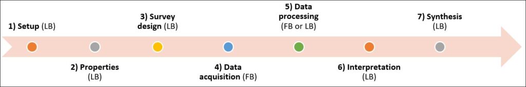
Figure 1. The life-cycle of a typical near-surface geophysical project involves both laboratory-based (LB) and field-based (FB) activities. The utilization of geophysical instrumentation (hardware and software) is imperative in any geophysical survey. Laboratory-based activities can be either in a classroom, office or laboratory.
Table 1. Example of an ideal undergraduate geophysical field camp course (commonly offered at geosciences departments from high-income countries). University A is Colorado School of Mines (Colorado, USA) focus on natural resources exploration geophysics. University B is the University of Houston (Texas, USA) focus on environmental geophysics. University C is CICESE (Baja California, Mexico) focus on environmental geophysics.
| Geophysical Method | University A | University B | University C |
| Survey GPS, GIS | + | + | |
| Well Logging: Gamma Ray, Temperature, Resistivity, Sonic Velocity | + | + | |
| Terrestrial Seismic Reflection | + | + | |
| Marine Seismic Reflection | + | ||
| Marine Surveying: CTD profiling, Side-scan Sonar, Sub-bottom Sonar Profiling | + | ||
| Seismic Refraction | + | + | + |
| MASW | + | ||
| Vertical Seismic Profiling | + | + | |
| Passive Seismic | + | ||
| Earthquake-related broadband seismic | + | ||
| Water Well Drilling | + | ||
| Gravity and Magnetics | + | + | |
| Ground Penetrating Radar (GPR) | + | + | |
| DC Resistivity | + | + | + |
| Self-Potential (SP) | + | ||
| Induced Polarization (IP) | + | ||
| Magnetotellurics (MT) | + | ||
| Audio Magnetotelluric (AMT) | + | ||
| Controlled Source Audio Magnetotellurics (CSAMT) | + | ||
| Time Domain EM (TDEM) and Frequency Domain EM (FDEM) | + | ||
| Joint Interpretation | + | ||
| Joint Inversion | + | ||
| Unmanned Aerial Vehicles (UAVs) and LiDAR | + | ||
| Hyperspectral Imaging | + |
A Geophysics Outreach Program For Latin American Geoscientists
While theoretical geophysicists work with equations, applied geophysicists work with actual geophysical instruments that measure and collect data. There is an instrument and software for every geophysical property that is measured. Hence, the lack of access or limited access to geophysical hardware and software is detrimental to applied geophysics college students’ academic growth and performance. The reality is that most Latin American geophysics undergraduate students have restricted exposure to geophysical hardware and software during their academic years. Of course, several geoscience programs across Latin American universities have a decent geophysical instrument pool to comply with and satisfy the educational curriculum.
Nevertheless, the equipment tends to be utilized for many generations, and replacing it with new versions is a constant financial and logistical overburden. Access to geophysical instrumentation might come after college graduation, such as an internship, work, or a graduate program if the students enroll in an M.Sc. or Ph.D. program. Additional opportunities, but at a cost, include national or international conferences that offer short courses on a specific geophysical method. However, the participant is forced to register for the conference before registering for the course. In addition, the traveling cost increases the overall expenses associated with the course; hence, the course becomes too costly to take.
When we were college students in Latin American institutions, we would have benefited from a college geophysics outreach program that provides geophysical hardware and software access. In 2017, when two of us (HRH, ER) worked together at a manufacturing facility of electrical resistivity imaging (ERI) hardware and software, we implemented a hands-on geophysics outreach program in Spanish focused on 2D and 3D ERI. It was in-person, cost-free, and collaborated intensely with geoscience departments in Latin American universities and research and government institutions. The idea of this geophysics outreach program arose when we realized that we could shorten this technological gap simply by visiting the universities. The main goal of the outreach initiative was to provide the Latin American geoscience community of students, professors, researchers, and active professionals with the instrumentation to create and facilitate meaningful experiences through hands-on activities aligned with curriculum standards and use established educational techniques (Walker, 2021).
The 2d & 3d ERI Workshops: Examples from Mexico and the U.S.
The inclusive geophysics outreach program consisted of a one or two-day workshop usually held in a university auditorium or large classroom, ideal for hosting large groups. The workshops extended to two days when the site of interest was located over 1 hour away from the university campus. The workshops facilitated networking and interaction during indoor and outdoor activities. Attendees experienced the entire life-cycle of 2D and 3D ERI surveys (see Figure 1). The workshop was structured in three sessions: (I) a compact oral presentation describing the fundamental concepts of the method and its technical applications, (II) hands-on activities dealing with the 2D and 3D ERI survey design and real 2D and 3D data acquisition exercises; and (III) the data processing, inversion, and interpretation of the acquired 2D and 3D data sets. For session II, the instructor prepared the group by preconfiguring the geophysical instrument and ensuring that everyone knew how to use it before going into the field. For session III, the instructor provided all attendees with a free, 30-days license of the geophysical software to invert and visualize 2D and 3D direct current electrical resistivity data; and explained the 2D and 3D data processing workflows step-by-step. The attendees engaged in technical discussions and interpretation of the 2D and 3D inversion results. The outreach program began successfully in Mexico, and it later propagated to other universities and government agencies in Latin American countries like Peru, Panama, Chile, Ecuador, Brazil, Colombia, and Costa Rica with popularity, acceptance, and success.
At the end of the workshop, the instructor made all material available via an open-source google drive so that attendees could practice with the material later. Finally, all attendees received a certificate of participation. The geophysics outreach workshop was hosted at six academic institutions, one government agency, and one hotel in Mexico. The settings of each workshop varied from urban to remote, with multiple geophysical targets varying from buried metallic objects archeological and geological features to intruding dike complexes and agricultural soils with high salinity. Examples of the 2D and 3D ERI deployments from some universities are shown in Figures 2 and 3, respectively. Figures 4 and 5 illustrate the examples of the 2D and 3D inverted resistivity models corresponding to Figures 2 and 3, respectively. A technical discussion and interpretation of these results are beyond the scope of this article.
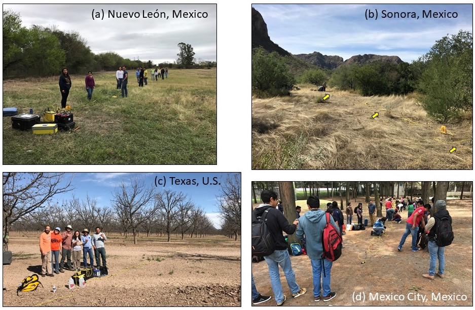
Figure 2. Example of a field photograph of workshop attendees participating in a 2D ERI survey at (a) the Universidad Autonoma de Nuevo León in Linares, Nuevo León, Mexico, (b) the Universidad de Sonora in Hermosillo, Sonora, Mexico, (c) the University of Texas at El Paso, Texas, USA, and (d) the Universidad Nacional Autonoma de Mexico in Mexico City. Attendees included college undergraduate and graduate students, active professionals, researchers, and professors. Latin American workshops commonly yield larger crowds. The results of the 2D inversion are shown in Figure 4.
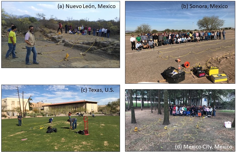
Figure 3. Example of a field photograph of workshop attendees doing a 3D ERI survey at the institutions mentioned in Figure 1. The results of the 3D inversion are shown in Figure 5.
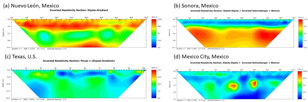
Figure 4. 2D inverted resistivity models obtained by the workshop attendees from the institutions mentioned in Figure 2.
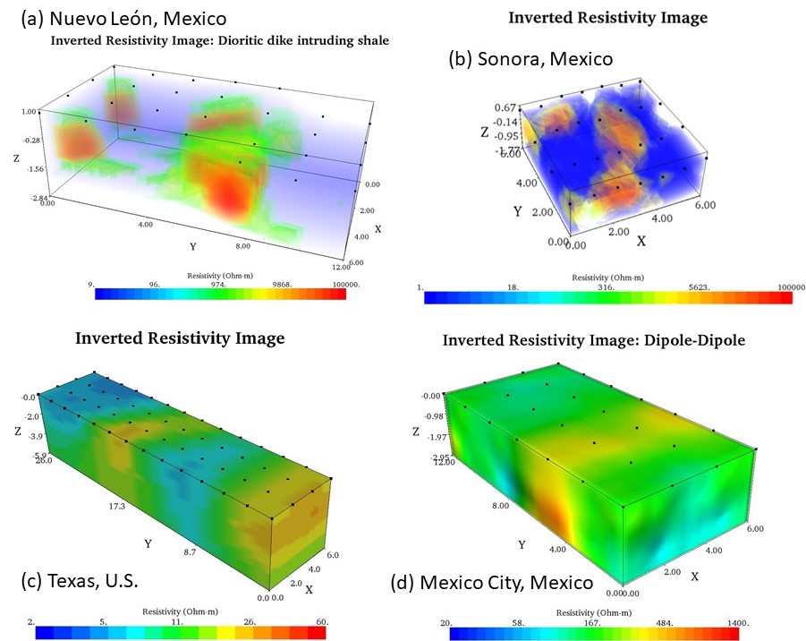
Figure 5. 3D inverted resistivity models obtained by the workshop attendees from the institutions mentioned in Figure 3.
Conclusions
Geoscience programs in high-income countries are better funded than in Latin American countries, providing better or more access to geophysical instrumentation and opportunities for meaningful hands-on activities. The issues of geoscience academic programs in Latin America are of different natures. Latin American countries invest significantly less in science, technology, engineering, and mathematics (STEM) than do high-income countries (Valenzuela-Toro and Viglino, 2021). Valenzuela-Toro and Viglino (2021) highlight the cumulative barriers that can hold Latin American researchers (i.e., academics and students) back from actively contributing to scientific fields or even getting experience with scientific tools. These systemic barriers include funding, visa applications for travel, language, access to literature, gender biases, and the unwritten rules of international networking and mentoring opportunities. These obstacles can also manifest to professionals and practitioners across various geoscientific fields.
Geophysics field camps are an interactive way to provide real-world training to students beyond what is taught in a classroom setting. Producing understandable and widely available outreach materials is pivotal in geosciences (Walker, 2021). A way to bring low-cost, hands-on geophysical experience to the Latin American geoscience community (e.g., students, professors, researchers, and professionals) is by bringing geophysical instrumentation to their hands in the form of short workshops in Spanish. Remarkably, our inclusive geophysics outreach program reached a broad Latin American geoscience community across various fields of geosciences. The hands-on activities of these geophysics field-based workshops positively impacted all participants’ learning experiences. This social inclusion approach and collaboration between industry and academia is unique because it offers participants ownership in a field-based learning environment.
The world of geophysical instrumentation/technology is quickly evolving. Geophysical instrumentation has seen significant improvements in how we collect and process data of various methods: faster data acquisition routines, wireless sensors, and connections to the data logger, drones implemented to some geophysical methods, data processing in the cloud, multi-method geophysical instruments, and the implementation of machine learning algorithms. However, future geoscientists, geoscientists in training, and professional geoscientists in Latin America still have limited access to geophysical instrumentation. In the current energy transition phase that spreads worldwide, we must revert this trend.
Acknowledgements
The authors are very thankful to every participant that attended each workshop and to any person involved in the planning, organization, and execution of each workshop.
References
Valdés-Moreno, B., Ramos-Barreto, A. L., Peña-Domínguez, J. G., and Ruiz-Aguilar, D., 2021. Applied Geophysics
Summer School SEG-CICESE 2021. Available at: https://seg.org/Education/Student/Student-Programs/Field-Camps/Posters. Last accessed on 01/February/2022.
Valenzuela-Toro, A.M, and Viglino, M., 2021. Latin American Challenges. Nature, vol. 598, pp.374-375.
Walker, J.D., 2021. Doing geology in an online world. GSA Today, 31(2), pp.4-7.
Whitmeyer, S.J., Atchison, C. and Collins, T.D., 2020. Using mobile technologies to enhance accessibility and inclusion in
field-based learning. GSA Today, vol. 30 (9), pp. 4-10.
Author Bios
Hector R. Hinojosa was born in Hermosillo, Sonora, Mexico. He has a BSc degree in geosciences from The University of Arizona, an MSc in structural geology from Ohio University, an MSc in geophysics from Miami University, and a PhD in applied geology from Cologne University. He is a licensed Professional Geoscientist in Texas. Currently, he is the Principal Geoscientist at Cordillera Geo-Services, LLC is also an adjunct faculty at the Department of Environmental Technology at Texas State University. He was a Junior Geophysicist and Senior Geologist, Geophysical Application Engineer at Advanced Geosciences, Inc. (AGI), and a Staff Geoscientist at the Seismological Station Bensberg of the Institute of Geology & Mineralogy of Cologne University, Germany. hector@cordillerageo.com
Jesús Roberto Vidal Solano was born in Santa Ana de Yécora, Sonora, Mexico. He has a BSc degree in geology and an MSc in volcanic petrology from The University of Sonora, a PhD in magmatic petrology and geodynamics from The Paul Cézanne University Aix-Marseille III, and a postdoc from The Caltech’s Seismological Laboratory of the Division of Geological and Planetary Sciences. Currently, he is a research professor at the Department of Geology at The University of Sonora UNISON. In Mexico, he has directed several bachelors, master and doctoral thesis, was coordinator of the Master of Science-Geology UNISON program, is currently president of the Academy of Geochemistry, Petrology, and Geodynamics of the Department of Geology at UNISON, and secretary of the National Institute of Geochemistry (INAGEQ).
Daniel Garza Rocha was born in San Nicolás de los Garza, Nuevo León, México. He has a BSc degree in Physics and Geology from the University of Nuevo León and an MSc in Geophysics from the Technical University of Clausthal, Germany. He is a professor in Geophysics at the Faculty of Earth Sciences at the University of Nuevo Léon, México.
Eduardo Rodrigues was born in Caracas, Venezuela. He is a Geophysical Engineer and MSc in Earth Sciences from Simón Bolívar University, and currently completing an Executive MBA at EAE Business School in Madrid, Spain. With more than 20 years of experience, he is the Principal Geophysicist for Latin America at Advanced Geosciences, Inc. for the last seven years. During his professional career, he has worked in geophysical exploration for oil and gas in Western Atlas of Venezuela, Professor in the Department of Earth Sciences at the Simón Bolívar University in Venezuela in electrical methods, general geophysics, field geophysics, and gravimetric methods. He worked on many projects of geophysics applied to groundwater exploration, mining, geotechnics, and the environment at TRX Consulting in Venezuela and Wellfield Services in Chile. eduardo@agiusa.com
