
By Baqir Al asadi1 and Andrew Spyrou1
1GBG Group
Abstract
Whether human induced or not, the effect of climate change on coastal communities is increasingly evident and presents a sizeable challenge for land use and development in these regions. Sea level rise and increase in frequency and destructive force of storm events are expected to accelerate coastal erosion and inundation in many regions putting assets and infrastructure at risk. As a requirement of Western Australia’s State Coastal Planning Policy, local councils through the process of Coastal Hazard Risk Management and Adaptation Plans (CHRMAP) are attempting to rate sections of Western Australia’s coastline with a risk level to assist in future planning for land use and infrastructure. Although this process allows for the presence of competent rock to be factored into erosion hazard estimation, current modelling often assumes a ‘sandy coastline’ where there is no evidence of rock along the beach foreshore or dune system. Such a conservative assumption can be erroneous in predicting whether existing infrastructure is in fact at risk and preventing proposed land development from extending shoreward. Geophysical subsurface investigation methods supplemented with geotechnical testing are particularly effective in determining whether there is in fact a continuous rock barrier located below the ground surface. Where present and with a sufficient strength and height, such barriers may prevent the advancement of erosion impacting infrastructure and potentially allow for a reduction in setback distances for future development.
Introduction – Western Australia’s Sandy Coastline
The South-West Region of Western Australia (WA) includes approximately 1500 km of predominately sandy coastline extending from the population centres of Albany in the South, through the state capital city Perth, and to Geraldton in the North (Figure 1). This section of coastline is characterized by long stretches of aeolian beach dunes deposits with few protective bays and is exposed to strong ocean currents and destructive storms.
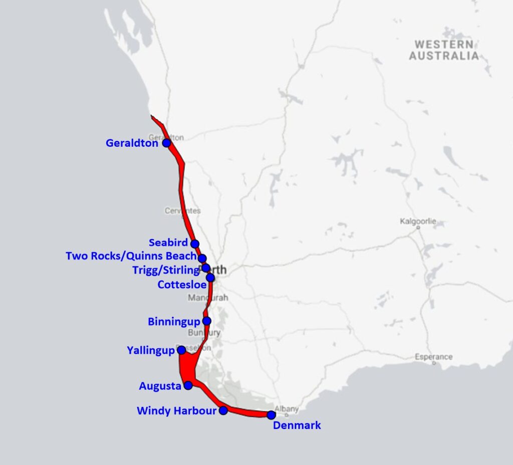
Figure 1: The sandy coastline of South-West Region of WA. Localities in blue are examples of where coastal geophysical investigations have been carried out.
Urbanization along this corridor coupled with the effects of coastal erosion has proved to be a sizeable challenge for local councils, land developers and infrastructure managers alike. Destructive storm events (Figure 2) and development that disrupts coastal processes (Figure 3) are amongst the key contributors to coastal erosion which poses a tangible threat to existing and planned coastal settlements.
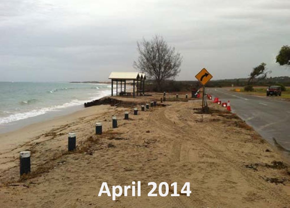
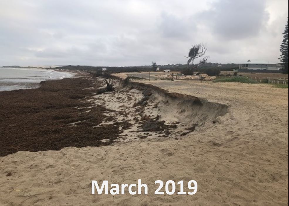
Figure 2: Effects of a destructive storm event on a section of sandy coastline north of Geraldton WA from April 2014 (left) and March 2019 (right).
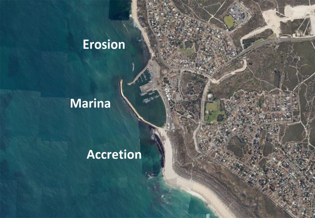
Figure 3: Erosion and accretion of beach sand related to coastal development such as marinas and ports disrupting coastal processes.
Coastal Management and Planning
Coastal Hazard Risk Management and Adaptation Planning (CHRMAP) is a process set out under the WA State Coastal Planning Policy. The aim of CHRMAP is to rate coastal areas of concern with a risk level for erosion and inundation, and to assist in future planning using the hierarchy of adaptation pathway from avoid, managed retreat, accommodate through to protect.
Under CHRMAP, coastal landforms can be classified as either “sandy coast”, “rocky coast”, or “mixed sandy and rocky coast” (Figure 4). Conventional surveys typically follow the assumption that where there is no evidence of rock along a beach foreshore or dune system, then this will be classified and treated as a sandy coast. However, without detailed knowledge on the type and condition of the natural subsurface material, such an assumption can be erroneous in predicting whether existing assets are in fact at risk and may also lead to conservative setback distances for proposed future developments.
The presence of continuous and competent subsurface rock at an appropriate location and elevation can form a natural barrier affording protection from coastal erosion. Geophysical investigations together with targeted intrusive testing can ascertain whether such rock is present and if so, model its spatial extent, level and condition.
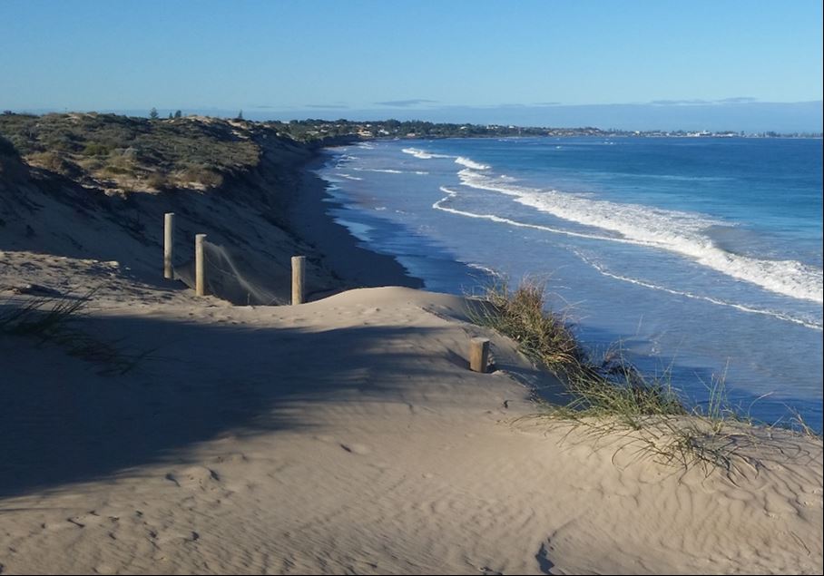
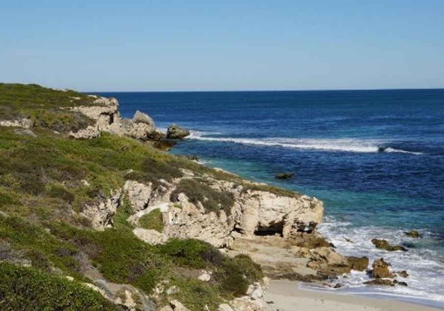
Figure 4: WA’s sandy coastline (left) and rocky coastline (right).
Geophysical Methods for Assessing Erosional Vulnerability
Geophysical methods together with targeted intrusive testing have proven to be effective in mapping the near surface geology of the coastal landforms within South-West WA. During such investigations definition of the following is sort:
• Thickness of sand cover, typically active or inactive aeolian beach dune deposits.
• Depth and indicative hardness/stiffness of underlying rock, typically variable strength, partially lithified to competent calcarenite.
• Identification of karstic dissolution features within the calcarenite including open, collapsed or infilled voids and caverns.
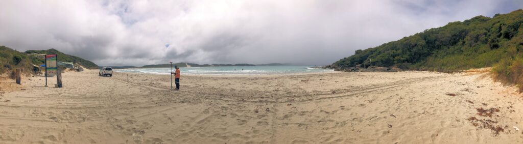
Figure 5: Geophysical investigation including spatial survey, Denmark WA.
Geophysical methods typically utilized for coastal investigations include Multi-channel Analysis of Surface Waves (MASW), Seismic Refraction Tomography (SRT) and Ground Penetrating Radar (GPR). GPR is a useful method to rapidly image the shallow subsurface and can produce high resolution cross sections imaging geological boundaries with contrasting electrical properties. However, the method does not give hardness or stiffness properties to ascertain rock condition and further to this imaging depths can be limited to the depth of the saline water table.
With SRT, the target interface between sediment and underlying rock typically results in a clearly defined refractor owing to their acoustic contrast. Furthermore, demarcation of the modelled compressional wave velocities can provide a measure of material hardness. However, definition of rock near mean sea level can be limited using SRT due to the interaction with saturated sands with the rockhead only interpreted when above mean sea level and classified as ‘0m or below’ when below this. Rockhead of the calcarenite typical of the South-West coastal region is highly variable often exhibiting pinnacle features. It is found that modelled SRT data does not account for this variability with the compressional wave first arrival tending to travel below the pinnacled rockhead as the quickest wavepath.
MASW (Figure 6) has proven to be the most robust method to obtain the objectives for coastal investigations as measured Raleigh waves are not influenced by groundwater table or local saturated sands and is tolerant to low frequency noise such as from wave action. Modelled shear (S-) wave velocities can also provide a measure of material stiffness for determination of rock condition. Unlike SRT, modelled MASW data provides high resolution sections for definition of variable rockhead (Figure 7) as well as the ability to image seismic velocity inversions for detection of karstic dissolution features (Figure 8).
Figure 6: MASW data acquisition using a seismic land streamer and vehicle mounted accelerated weight drop, Trigg WA.
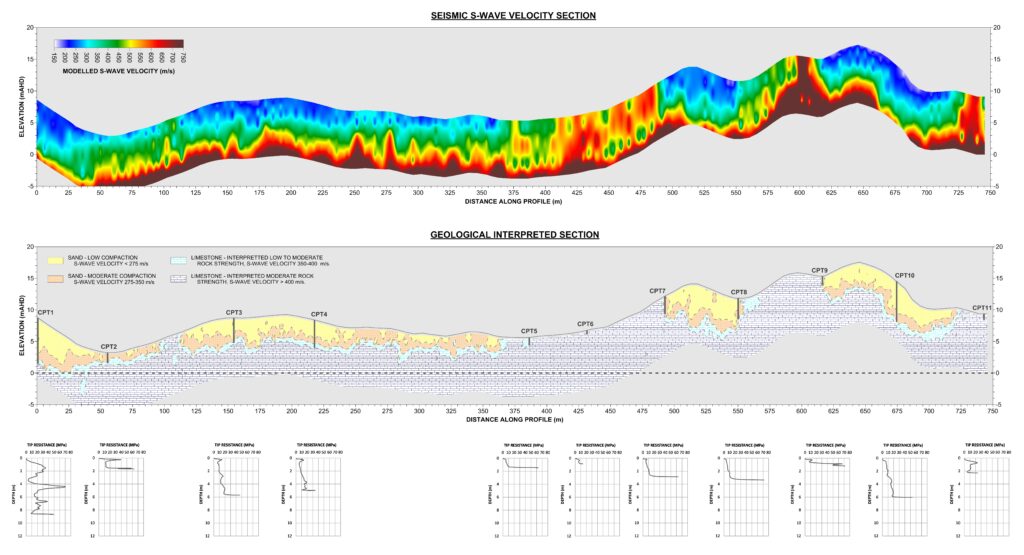
Figure 7: Seismic shear-wave velocity section (top) and interpreted section calibrated with intrusive testing (bottom) over a 750m length of coastal dune system showing variable depth to rockhead, Two Rocks WA.
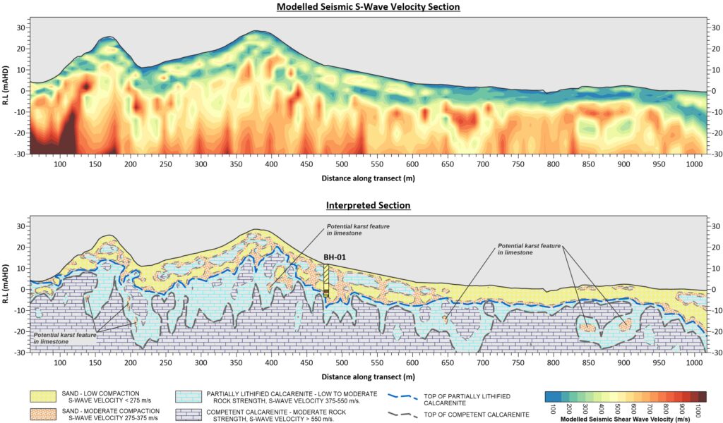
Figure 8: Seismic shear-wave velocity section (top) and interpreted section (bottom) over a 1000m length of coastal dune system showing velocity inversions relating to potential karstic dissolution features, Kemerton WA.
Calibration with Intrusive Testing
Intrusive testing is a key component for the calibration and ground ‘truthing’ of any geophysical testing for near surface investigations. Investigations of coastal landforms illustrates the wide range of material types and conditions encountered, and the potential uncertainty of the contrast in material properties and defining layer boundaries. Cone Penetration Testing (CPT) has been shown to be an effective intrusive method for such investigations in South-West WA (Figure 9).
CPT plots often show a strong correlation with MASW S-wave velocity soundings owing to the measured parameters of both methods being related to material stiffness under certain conditions. As such CPT at targeted locations within a project site can be used to calibrate MASW results by determining S-wave velocity values for boundaries for different material types, and to aid in interpretation by providing information on the condition of such material.
In a generalised form, 3 distinct layers (Figure 10) can be identified during coastal investigations in South-West WA as follows:
- Low CPT response and low MASW S-wave velocity measured for beach and dune sand of low compaction.
- Variable CPT response and moderate MASW S-wave velocity measured for indurated sediment including lenses of partially lithified calcarenite, and weathered calcarenite.
- CPT refusal and high MASW S-wave velocity measured for competent calcarenite.
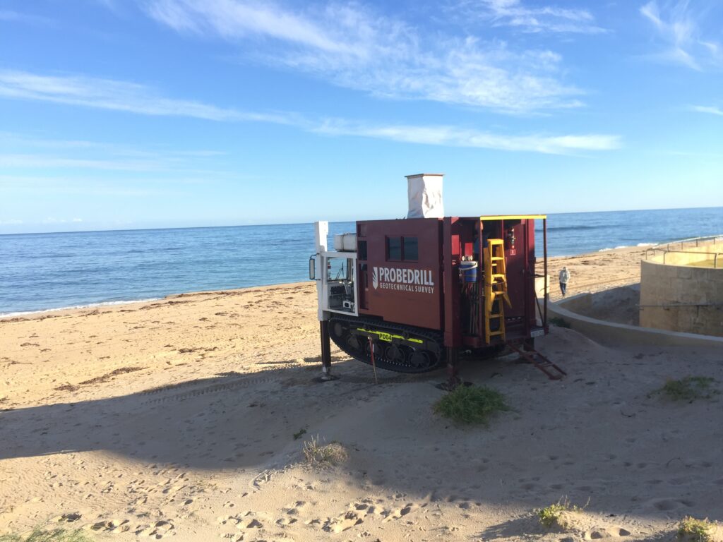
Figure 9: Cone Penetration Testing carried out by Probedrill, Binningup WA.
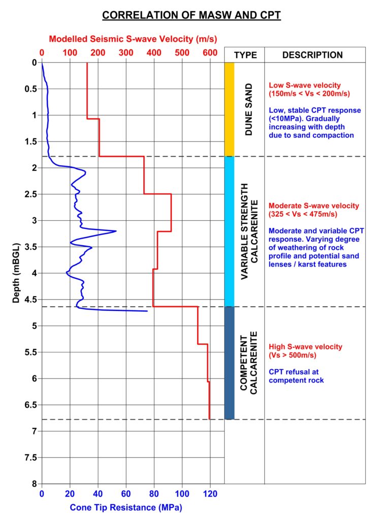
Figure 10: Correlation of MASW shear wave velocity sounding with CPT resistance plot.
Modelling Geophysical Datasets
The results of geophysical investigations using seismic methods are typically presented as the processed and interpreted dataset in a series of 2D cross-sections similar to Figures 7 and 8 above. Provision of multiple cross-sections in 2D space however does not give a complete overview of a site especially for end-users who may not be familiar with or have access to 3D GIS software.
A simple yet effective output where multiple transects have been acquired is to present the interpreted and calibrated level to the identified subsurface boundaries including the top of rock and thickness of overlying sediment as contour maps (Figure 11). These can provide an overall visual summary of often complex datasets, allowing the end user in a first pass to assess areas at most risk and areas where underlying rock may form a natural barrier to erosion.
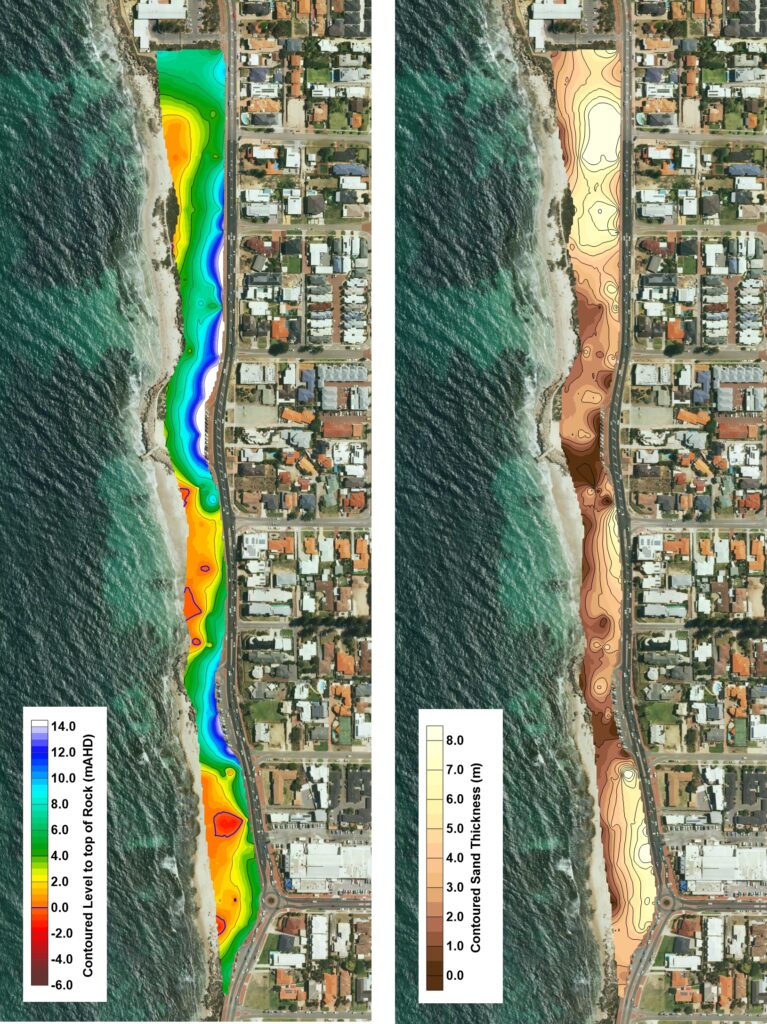
Figure 11 Contour maps generated from multiple seismic transects showing the modelled level to rockhead (left) and thickness of overlying sand (right), Trigg WA.
Conclusions
Much of the south-west Western Australian coast is classified as sandy due to the absence of any surface evidence of rock. Sandy coast can be particularly vulnerable to erosion and inundation with efforts being made to assess the vulnerability of coastal communities, assets and infrastructure, and to subsequently develop plans to mitigate this threat.
Through well planned and executed geophysical investigations supplemented with targeted intrusive testing, a robust near surface geological model of the coastal landform can be obtained. These models can be utilized to ascertain whether there is in fact rock at an adequate level and condition which can form a barrier to coastal erosion and hence afford protection to landward infrastructure. From experience gained during geophysical investigations along the South-West WA coastline, modelling and analysis of geophysical datasets both as cross-sections and contour maps can assist in effective coastal development planning and management.
References
C. Bicknell, 2010, Sea Level Change in Western Australia – Application to Coastal Planning. Department of Transport.
A. McPherson and A. Jones, Perth Basin Geology Review and Site Class Assessment. Geoscience Australia.
Western Australian Planning Commission, 2013, State Coastal Planning Policy Guidelines.
J. R. Gozzard, 2007, Geology and Landforms of the Perth Region. Western Australia Geological Survey.
Author Bios

Andrew has been with GBG since 2006, starting as a graduate geophysicist based in Sydney. In 2012 he relocated to Perth to take on the position of Senior Geophysicist managing the GBG Perth office and 2018 as Operations Manager, Western Australia.
During his time with GBG, Andrew has carried out geophysical investigations for a variety of engineering and environmental applications throughout Australia. In WA he has extensive experience carrying out investigations for iron ore infrastructure in the Pilbara and land development sites in Perth and the south-west.
Andrew’s current areas of interest include applying near surface geophysical test methods for coastal erosion vulnerability studies, and acquisition and analysis of Ground Penetrating Radar datasets for transport infrastructure assessment including road and rail.

Baqir has been with GBGMAPS since June 2015. After graduating from Curtin University, he took the position of Geophysicist and then as Senior Geophysicist with GBGMAPS in Western Australia.
During his time with GBGMAPS he has worked on, and project managed geophysical and non-destructive investigations for a variety of different applications. His responsibilities include Business Development, data acquisition, processing and interpretation, and the preparation of drawings and reports.
His current areas of interest include the acquisition, processing and interpretation of Ground Penetrating Radar (GPR) for geotechnical and NDT investigations, groundwater investigations and the use of MASW for compaction assessment.
