
By Kim Tremaine and John Lopez
Introduction
Tremaine & Associates carried out electromagnetic induction (EMI) surveys over five days in September 2003 for the Giza Plateau Mapping Project directed by Mark Lehner of Ancient Egyptian Research Associates (AERA). This work, part a geophysical pilot study, was conducted on behalf of AERA in collaboration with the Supreme Council of Antiquities and sponsored by the National Geographic Society (Figure 1). During this effort, 200 acres (68 linear miles) were covered, resulting in the acquisition of ~785,000 data points. The aim was to map the near-surface landscape and buried features within six areas of interest, including: (1) Menkaure’s Quarry and Central Wadi; (2) the Southern Highlands; (3) Menkaure Valley Temple (MVT) and Khentkawes Town (KKT); (4) Heit el-Ghurab (HeG) and the Worker’s Complex in the southern flood plain; (5) the Wall of the Crow (WOC) and parking lot at the mouth of the Wadi; and (6) the Mena Golf Course in the northern flood plain (Figure 2A & 2B). Preliminary results were first reported by Lopez and Armstrong (2003) and later by Dash (2004).
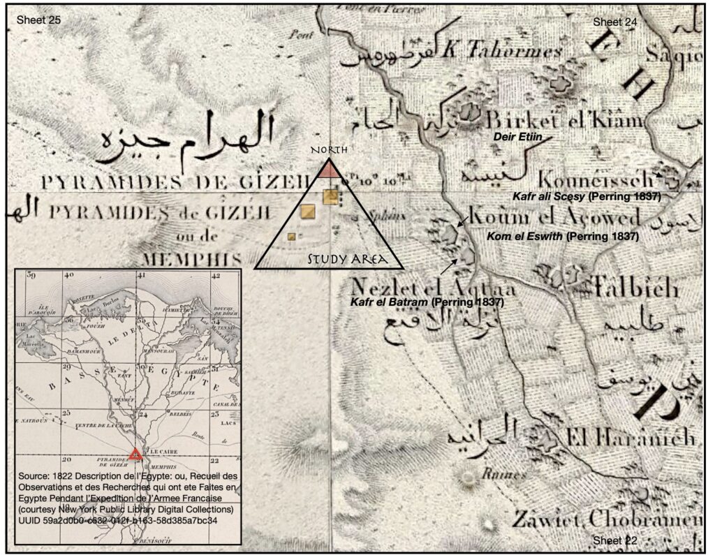
Figure 1. Location of study area.
The goals were to identify potential buried structural remains (e.g., tombs and buildings) as well as identify broader landscape features, whether geomorphological or due to cultural terraforming, with special interest in delineating a hypothesized harbor system that provided access from an ancient branch of the Nile westward to the Giza plateau during Egypt’s Fourth Dynasty (a golden age of the Old Kingdom c.2613 to 2494 BC) when the three pyramids were constructed (Khufu, Khafre, and Menkaure). These pyramids, depicted in Figure 1, are shown within the context of the early 1820s, in relation to the surrounding towns and Cairo, prior to modern development.
Methods
A towed frequency-domain EM instrument, the EM3, was used. It consisted of a transmitter and three receivers operating at a frequency of 9.8 kHz, recording three volumes of soil to a maximum depth of 10 meters (an effective depth of 6 m), gathering four samples per meter (Figure 2C). The primary field induced electrical currents in conductive subsurface materials that in turn generated secondary magnetic fields, which were detected by the three receiver coils spaced at 1, 2, and 3.6 meters from the transmitter. The secondary field consisted of two components, the quadrature and in-phase responses reflecting Apparent Conductivity (AC) and Magnetic Susceptibility (MS).
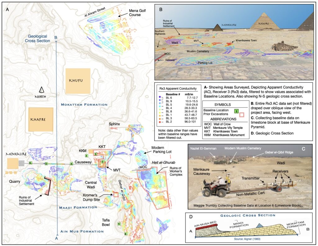
Figure 2. Baseline apparent conductivity data (Rx3) overlain on topographic map showing instrument array and survey locations.
Close attention was paid to the geology within the study area, including the Mokattam, Maadi, and Ain Mus formations, as well as the Quaternary dune, wadi, and floodplain (Figure 2D). Responses were measured for several minutes over known rock/sediment types (9 representative locations) to obtain AC values. This baseline data was intended to be used to assist in modeling and analysis (Figure 2A, 2B).
A mixed strategy was used to achieve the goals of the pilot program. Detailed investigations were undertaken in areas where prior archaeological excavations had occurred, serving to test the effectiveness of the technology for detecting features of interest (e.g., MVT, KKT, and HeG). These areas were surveyed with transect spacings between two and seven meters apart. For investigations to gain an understanding of the geology/geomorphology and landscape level features, transects were generally spaced 20-30 meters apart where feasible. Areas of very rough or steep terrain as well as areas with exposed tombs etc. were avoided. In both the broader and detailed survey efforts, transects were gathered roughly North-South and East-West when possible, and occasionally using sinusoidal passes.
Preliminary Results
In 2003, the data were processed using Surfer to produce AC contour plots, graphical plots, and visualized using shaded relief (Figure 3C). Limited inverse modeling was also conducted to produce 3D models using Emigma (Petrous Eikon software). The results suggested we were able to detect structures of both mud-brick and limestone. In the Worker’s Cemetery along the east slope of the Southern Highlands, rectilinear features believed to be sand filled shafts and tombs were identified. It was concluded that with additional processing, more information could be extracted, including composition of the buried structures, depths to features, and thickness of sand in the quarries.
Fast forwarding 20 years, numerous excavations and discoveries have taken place coinciding with areas Tremaine surveyed, providing an extraordinary opportunity to mine the data for additional insight. The sections that follow present our findings in context, taking into account various maps, sketches, and photographs ranging from the earliest explorers (1780s – 1880s) to recent excavations (2000s – 2020s). It also leans heavily on summaries and interpretations put forth by Mark Lehner and others. The first section emphasizes focused views of the six areas of interest identified above. The second section steps back and takes a birds-eye view of the larger landscape, suggesting refinements to Lehner’s most recent model of the harbor works that were essential to the building of the pyramids (Lehner 2020).
Menkaure’s Quarry and Central Wadi
Menkaure’s Quarry is situated SE of Menkaure’s Pyramid (Figure 2). The Central Wadi, at a lower elevation, is found east of the quarry, south of Menkaure’s Causeway, and west of the Gebel el-Qibli ridge, at the interface between the Mokattam and Maadi formations This portion of the wadi is likely another quarry that is currently filled with outwash from intermittent flooding and thick wind-blown sands. Figure 3B shows the field conditions at the time of survey. Our 2003 contour plots showed very low conductive responses, consistent with values associated with sand. At both ends, abrupt transitions to higher conductive areas are shown (Figure 3C). The higher conductive responses on the east edge lie directly adjacent the modern Muslim Cemetery. Those on the west are sandwiched between Menkaure’s Quarry and the Central Wadi. The lack of features in the wadi itself was attributed in 2003 to lack of physical contrast between any archaeological features and surrounding sand, the possibility that features were buried too deep to detect, or that no features were present.
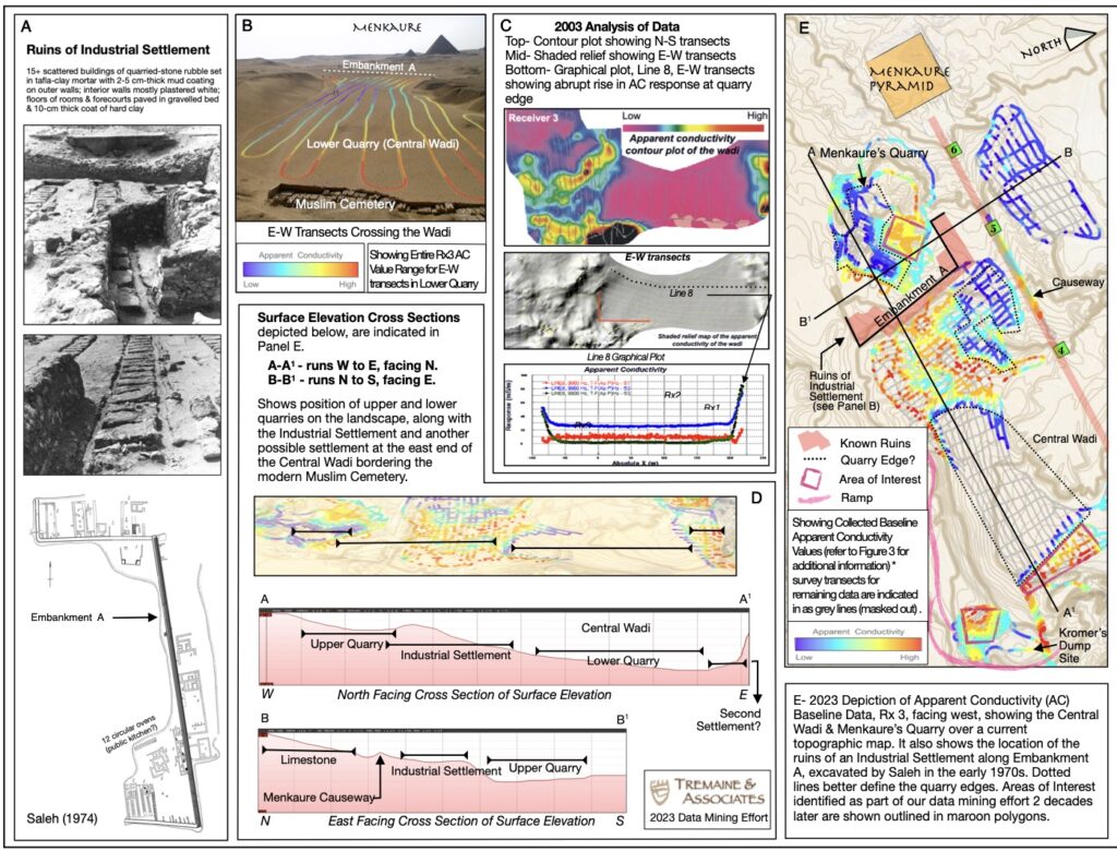
Figure 3. Central Wadi and Menkaure Quarry.
In 2023, after reexamining the data with the benefit of hindsight, we are better able to make sense of things within a broader context. Figure 3A shows the ruins of what is referred to as an Industrial Settlement excavated by Saleh (1974) about 50 years ago. At that time, he delineated a wall (embankment) running N-S across the upper end of the Central Wadi (elevation of ~52m asl). Figure 3D presents both W-E and N-S surface elevation cross sections, showing the settlement situated at a higher elevation relative to the Central Wadi or Menkaure’s Quarry. While Tremaine’s survey didn’t cover the settlement as delineated in 1974, the higher conductive responses we obtained at the upper end of the Central Wadi lie directly adjacent to the settlement. Responses are likely associated, whether related to structural ruins or a dumping ground. Figure 3E shows a visualization of just the baseline Rx3 AC data for both the Central Wadi and Menkaure’s Quarry. The tracks for the remaining data are shown in gray but have been masked out to reveal additional patterning. The dashed black lines delineate what are surely the edges of quarries in both the upper and central portion of the wadi. Geometric features of interest are shown in reddish outline. The results provide food for thought and various testable hypotheses that can further our understanding of this portion of the Giza Complex.
Southern Highlands
Figure 4A is a spectacular panoramic view from the top of Khafre’s Pyramid found in Lepsius (1842) which shows the Southern Highlands (Gebel el-Qibli) in relation to the Central Wadi and Menkaure’s Quarry, described in the previous section. It also shows the relative position of Saleh’s (1974) embankment featured along the long axis of the Industrial Settlement. Note, as well, a ramp running from the settlement to what is now referred to as Kromer’s Dump Site (Kromer 1978). Figure 4B is a photograph showing the survey conditions during our data collection in 2003 from the south end facing NW. The ridge line with Ain Musa outcroppings is evident to the right-hand side of the frame with Khufu Pyramid in the background. Figure 4C is another view of the ridge and western slope from the north end facing south. The location of Kromer’s Dump site is also shown. This site was originally excavated by Karl Kromer in the 1970s and later investigated by AERA in 2018 (Lehner 2018a & 2018b; Witsell 2018).
The 2018 AERA excavations revealed tip lines for tossed debris sloping in two directions, down to the east (as expected if coming from the west) as well as to the west (as expected if coming from the east). Much of the debris was identified as pure quarry crush produced by shaping limestone blocks with hammers and chisels (Lehner 2018b). In addition, however, there were also layers of settlement waste from everyday living activities intercalated with the quarry crush (e.g., copper fishhooks and sewing needles, dietary bone, and fragments of dark gray mudbricks from Nile alluvium).
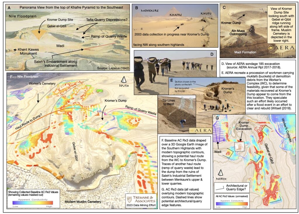
Figure 4. Southern Highlands.
Tremaine’s 2003 EMI survey passed the upper corner of Kromer’s Dump Site when dropping down the west slope of Gebel el-Qibli. Figure 4F depicts only the Rx3 AC baseline data with other values masked out in an attempt to accentuate features. Figure 4G shows the same dataset without masking. Several rectilinear features are apparent. One is situated on the southeast rim of the Central Wadi adjacent Kromer’s Dump Site. It has high conductive baseline values in the center, transitioning to lower values at the perimeter (i.e., from red to yellow to aqua to blue). The other two features, in reverse, appear as low conductive baseline values in the center, transitioning to high values at the perimeter (i.e., from blue to aqua to yellow to red). These may reflect filled in quarrying activities or structural ruins. For positive identification, additional investigation is needed.
The high conductive values found in the narrow valleys between Ain Musa outcroppings may reflect the yellowish desert marl clay called tafla that is known to have been quarried for use in mortaring and plastering ramps, embankments, and other architectural features. The high conductive values at the southern end of the ridge, bordered by a low conductive rectilinear feature, are likely associated with the Worker’s Cemetery, possibly tombs made with mud-brick. Again, for positive identification, additional investigation is needed.
Menkaure Valley Temple/Khentkawes Town Complex
The MVT and KKT are situated at the east end of the causeway leading to Menkaure’s Pyramid at the mouth of the Central Wadi (~18m asl). Figure 5A is a photograph of excavations by Reisner in 1910. Ruins of the Menkaure Valley Temple are shown in the foreground with Khentkawes Town in the mid-ground and Khufu Pyramid in the distance. Figure 5B is a photograph of this same view in 2003 during Tremaine’s survey. Nearly 100 years later, backfilling and windblown sand left very few surface indicators to suggest the temple’s presence. Figure 5C, again, is a photograph of the same view in 2019. Crews with AERA are in the process of re-exposing this location.
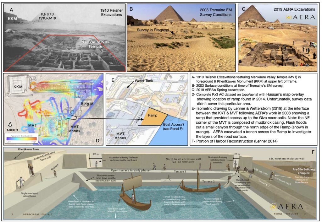
Figure 5. Menkaure Valley temple and recent findings of ramp providing access to hypothesized water basin.
The results of the EMI survey are presented in Figure 5D, showing Rx3 AC data (unfiltered) overlaid on a plan of architectural features excavated by Hassan (1943) and recent mapping by AERA. It is notable that the western portion of KKT, primarily built of mudbricks, yielded high to moderately conductive responses in contrast to the eastern portion and foot of the L-shaped town. This section, as reported by Lehner et al. (2006), was founded on a terrace of crushed limestone debris which explains the lower AC values. Most of the mudbrick had been eroded away having been subject to wind-blown sands. Only traces of mudbrick millimeters thick were found preserved along the western enclosure wall.
Notably, an artificial 90-degree cut was discovered in the bedrock paralleling the east enclosure wall, creating a vertical drop of more than 2 meters (Lehner et al. 2006). A mudbrick building was found below, perched on a lower terrace of crushed limestone debris, buried in fine silty sand and discarded limestone debris from modern tomb building in the adjacent Muslim Cemetery. This likely explains the low conductive responses obtained during our survey in that portion of the town. This feature is hypothesized to been deliberately constructed to create a water-filled basin which extended the reach of boat/barge access to this area, facilitating the delivery of supplies to the town occupants (Lehner2014; Lehner and Wetterstrom 2019). A model of this feature is depicted in Figure 5F.
Heit el-Ghurab and the Worker’s Complex
HeG is situated within the Nile floodplain (~15m asl) on the east side of Gebel el-Qibli just south of the WOC. Figure 6A shows the results of our 2003 survey, Rx3 AC baseline data, with an overlay of faint geometric outlines demarcating the architectural layout partially mapped prior to 2003. The goal was to test how much detail the geophysical technology would be able to detect. Figure 6B shows an updated map of the various sections of HeG, including the Western and Eastern Compounds, the Gallery Complex, various houses, barracks, magazines, courtyards, vestibules, streets, enclosure walls, service quarters (bakeries, breweries), and the Royal Administration Building (RAB) (Lehner 2019). Despite closer spaced transects, details of the buried walls and contents were only roughly distinguished, most likely differentiating between construction material types. In some cases, this may be due to the condition of the ruins. The area to the northeast, especially, was found to have been subject to past flood events and post-occupational erosion and/or scouring, causing mudbrick walls to tumble and partially dissolve into settlement sludge (Butzer 2001; Lehner 2007). Figure 6E shows some of the better-preserved architecture from an excavation of the Western Compound with the WOC and Khufu’s Pyramid pictured the background (Lehner 2010; Lehner and Tavares 2010).
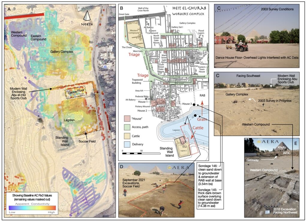
Figure 6. Heit-el-Ghurab and worker’s complex.
Figures 6C and 6D are photographs showing conditions at the time of survey. Note, the data gathered over the modern dance floor of the Abu Sports Club had to be disregarded due to heavy electrical interference from overhead lights (Figure 6C). Figure 6D shows a recent AERA excavation in 2021 of the soccer field (part of the Abu Sports Club) adjacent the Standing Wall Island (SWI) at the southern end of HeG. Lehner hypothesizes that a lagoon was formerly situated between the RAB and the SWI, serving to help distribute deliveries of grain and cattle to support the laborers, craftsmen, and administrators (Figures 6B and 6D). South of the soccer field, AERA excavated four large test pits to depths from 14.7 to 12.6m asl using a front loader (Lehner et al. 2006). Only clean sand was found down to the water table.
Wall of the Crow and Entrance to the Necropolis
The WOC is situated directly north of HeG. Figure 7A is an early sketch of this monumental wall and gateway in 1837 (Vsye and Perring 1839). Figure 7B is a photograph of this same viewpoint in 2003 during set up of our GPS base station. Figure 7C is an aerial photograph of the area that same year, showing the survey conditions. Note, the only unobstructed area that could be covered was a modern parking lot, as it was hemmed-in to the south by the WOC, to the east by the modern town of Nazlet el-Semman, and to the west by the modern Muslim Cemetery. Figure 7D presents Rx3 AC data (all values rather than masked to show only baseline values). Most of the parking lot yielded low conductive responses. Slightly higher values were obtained in a portion at the western edge adjacent the cemetery. This response may represent an extension of the cemetery.
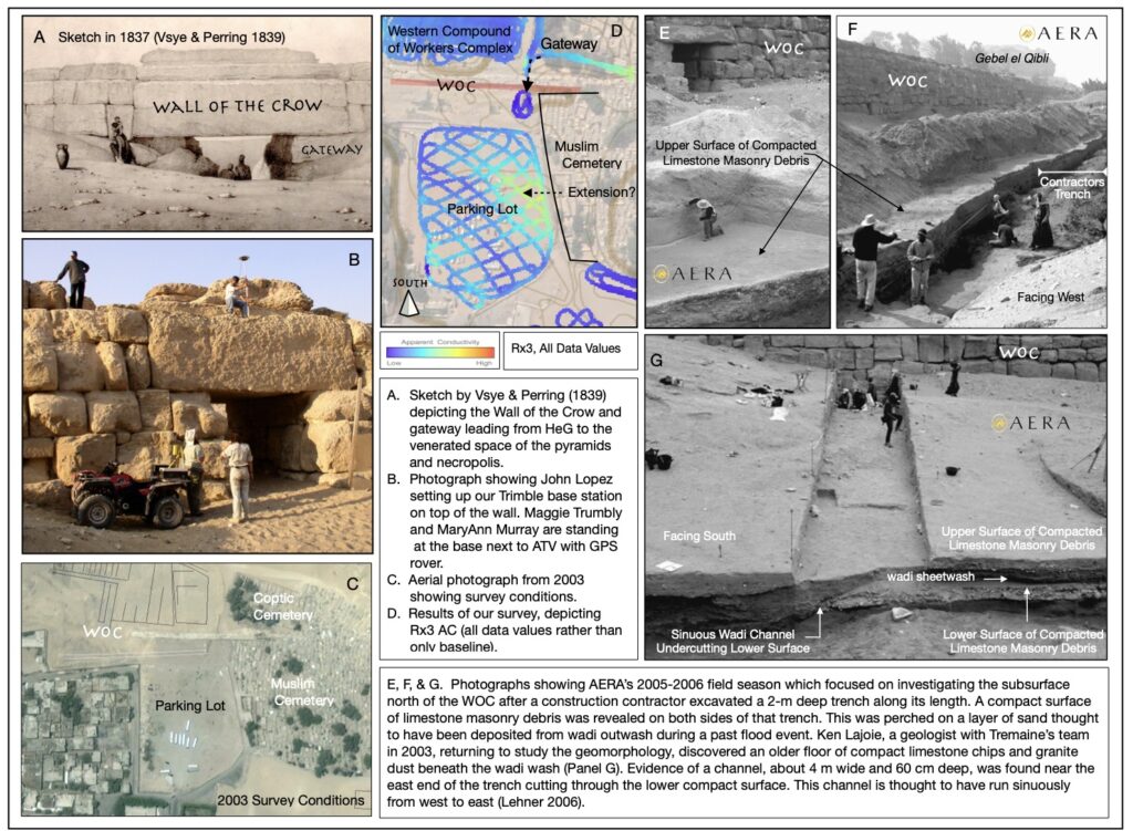
Figure 7. Wall of the Crow and gateway to pyramids.
In the year following Tremaine’s survey, AERA conducted field investigations just 20 meters north of the WOC, taking the opportunity to examine the walls/stratigraphy revealed along a 90.5m long construction trench (some 2m deep and 4.5-7m wide), in the process, clearing back the spoils to reveal a compacted limestone masonry debris surface situated around 16.3m asl (Lehner et al. 2006). Figures 7E and 7F are photographs of the exposed surface facing southwest and westward, respectively. Figure 7G is a photograph showing wadi sheetwash at the base of this compact surface, overlying a deeper limestone masonry debris surface lying about 15.3m asl. This last photograph also shows a channel of the wadi undercutting the lower surface. Lehner et al. (2006) believes these surfaces represent successive intentional paving events over natural wadi deposits, creating a terrace shoulder that edged what he hypothesizes was a central canal/water basin delivery system that extended to the foot of Khentkawes Town and northward, reaching the Sphinx Complex at the base of Khafre’s pyramid and Khufu’s harbor (Note: more to come in upcoming section).
Mena Golf Course
The golf course is situated in the floodplain just northeast of Khufu’s pyramid. Figure 8A shows the approximate location on one of the earliest available maps for the area, drawn by Frederik Ludvig Norden in 1780. He notes the cultivated floodplain in the foreground is subject to seasonal inundation. A village, thought to be Deir Etiin, is shown adjacent a N-S running canal (Bahr el Libeini). Figure 8B, a sketch by Norden in 1780, shows a view of Khufu’s Pyramid and this same village. Figure 8C is a 2003 photograph of the survey conditions. Figure 8D is a 1915 aerial photograph showing inundated terrain in the vicinity of the golf course (note: German WWI plane is pictured in the upper righthand corner). Another historic photograph, ca. 1895-1915, again shows inundation in the vicinity of the golf course (Figure 8D). Note the embankment along the left side of the frame (now Al Ahram Street), with Khufu Pyramid in the background. Figure 8F, another historic photograph (viewed from the north), shows the Mena House Hotel to the right side of the frame with the golf course appearing relatively dry.
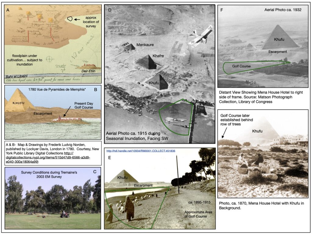
Figure 8. Mena golf course, 1780 map and sketch of location, series of historic photographs and survey conditions in 2003.
Figure 9A shows the entire set of Rx3 AC data overlaid on a contour map, hemmed between Khufu’s Causeway and Al Ahram Street (the embankment shown in Figure 8E). Note the lower conductive values to the west in contrast with higher conductive values to the east. This contrast may simply represent differences in sediment type (e.g., sands derived from the adjacent plateau versus silts from the floodplain deposits of the Nile). Figure 9C, a graphic adapted from Lutley and Bunbury (2008), shows the eastern portion of the golf course situated on remnants of a levee bordering a relict channel of the Nile1.
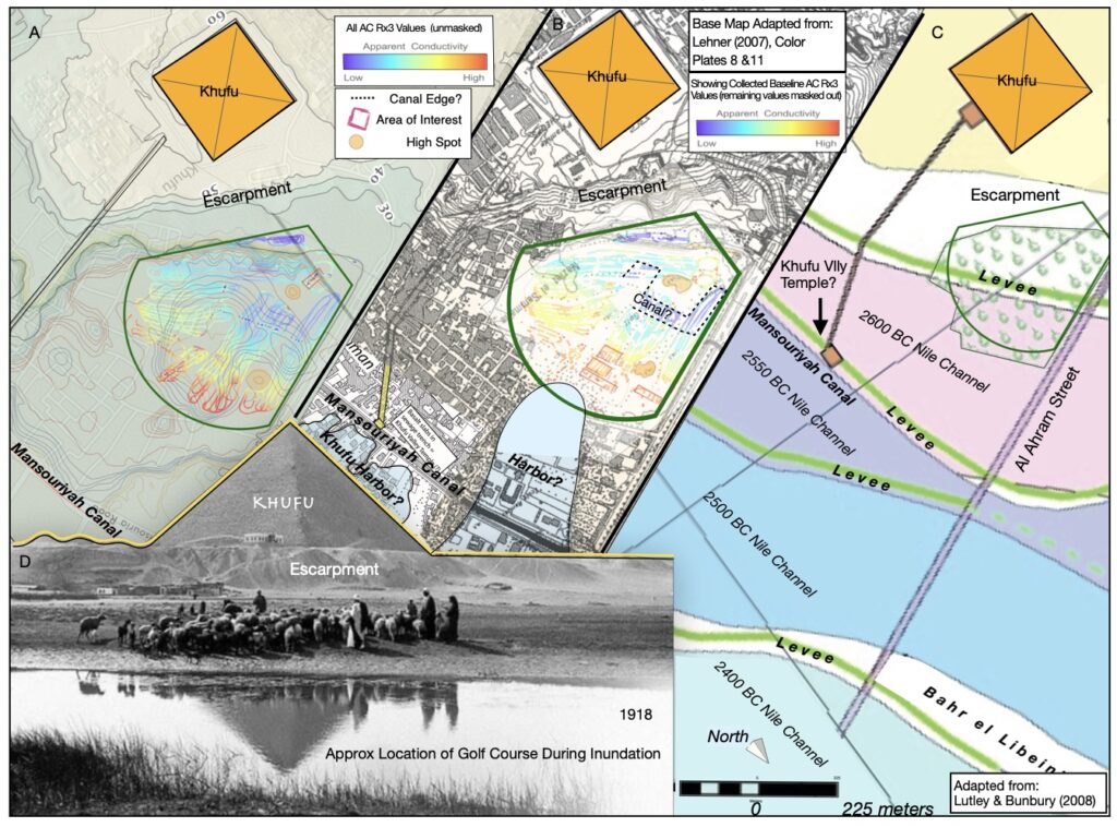
Figure 9. Mena golf course showing AC data over topographic map, over MHR 1:5,000 map series and geomorphologic map.
The Rx3 AC baseline data suggest the responses may be influenced by more than just sediment differences. Figure 9B depicts the baseline data overlaid on a Ministry of Housing and Reconstruction (MHR 1977) 1:5,000 map with Lehner’s (2007) delineation of the possible locations of Khufu’s Valley Temple and his harbor developments. The higher conductive responses at the east end of the fairways are patterned, showing geometry suggestive of the presence of structural ruins. The 1915 aerial photograph (Figure 8C) supports this hypothesis, showing buildings marooned on a small high spot surrounded by water in this vicinity. This high spot is one of two demarcated on the MHR contour map (Figure 9B). Lower AC responses shown in blue (in contrast to aqua colored responses) can be seen situated between these high spots, running N-S with straight parallel edges, suggestive of a canal (an extension of Khufu’s harbor?). Another area of interest lies directly west of the western high spot. It is better visualized in Figure 9A. In 2003, our geophysicist, Dr. Yi Liao, thought this may be a 2nd sphinx. Certainly, some man-made infrastructure is situated there (whether modern or ancient remains to be determined).
Birdseye View of Giza’s Harbor Works
In 1994, Zahi Hawass reported discovering a retaining wall (231 ft long & 10 ft wide) of huge limestone and basalt blocks buried three feet below the surface along Zaghloul Street, approximately 1,600 feet east of Khufu’s Valley Temple (1997). This discovery launched a quest, still ongoing after 30 years, to find additional remnants of this ancient harbor, now regarded as the essential framework that enabled the building of the pyramids. Water, rather than aliens, made it possible to transport hundreds of thousands of stone blocks (averaging 2.5 tons each) from both local and distant quarries.
With the gift of hindsight, leveraging bits of knowledge gained over the past two decades by various researchers, we dusted off the data and sifted through it again. Lehner (2020), recently updated his model of the harbor works based on multiple lines of evidence including bore logs, archaeological findings, and a first-hand account written by a boat captain navigating the waterways at that time2. Bore logs suggest the presence of a very deep channel, thought to have been dredged from the west levee of Khufu’s Branch of the Nile, running through a gap between two settlement mounds (Nazlet el-Sissi and Nazlet el-Batran East) toward the Sphinx and Khafre Valley Temple at the edge of the plateau. Archaeological evidence, some of which is reported above in sections discussing findings at MVT/KKT and the WOC, suggest the perimeters of dredged delivery basins were terraced, sometimes edged with casings of mudbrick, paving of crushed limestone, and accessed via ramps fronting the marina landings.
In 2003, one of Tremaine’s goals was to identify elements of the harbor in the vicinity of the Sphinx and Khafre’s Valley Temple. At the time, survey conditions in this area were challenging, making interpretation difficult. Lehner’s (2020) model of the waterways show this area as a landing at the western end of the Central Canal Basin (Figures 10A). Figure 10B presents Tremaine’s Rx3 data (all values) over Lehner’s reconstruction of waterways. This birds-eye view of the data in context starts to make sense. When the data are filtered to show just the baseline data, additional patterns begin to emerge. Our effort was made with the aim of reassessing the value of our data, and with the hope of contributing either additional insights or at least identify additional hypotheses to test in the future. It represents a certain amount of interpretation using the distinct baseline data tied with ground truthed findings by AERA and others, as well as reasoned interpolations based on topographic contours and historic photographs etc.
We established, in an earlier portion of this paper, that dark blue baseline data from the Central Wadi area clearly demarcated quarry edges. At the interface between the plateau and the floodplains, at the mouth of the Wadi, the blue baseline data appear to continue to outline the edges of quarries that were transformed into basin perimeters. Similarly, aqua-colored baseline data appear to coincide with terracing found at MVT/KKT and crushed limestone paving at the foot of the north side of the WOC. The warmer yellow, orange, and red conductive values are known, in many instances, to coincide with mud-brick structures. With this in mind, we drew light-blue semi-transparent polygons to outline proposed waterways (basins and canals) and light-aqua semi-transparent polygons to outline proposed terracing and paved surfaces at the perimeters of these waterways. These terraces/surfaces tend to front the warmer AC values which often coincide with known settlements. It is acknowledged that our interpretation is speculative and that in the long run, it may not hold under scrutiny. It does, however, raise questions that may prove fruitful for future researchers.
Among the most compelling possibilities is that Lehner’s Central Canal Basin may have extended past the south side of MVT and run N-S along the east edge of the Central Wadi, at the western base of Gebel el-Qibli, providing access to a potential unidentified settlement (see Figures 3E and 10D). Similarly, findings at the Mena Golf Course may indicate the presence of a canal with perimeter terracing/paving fronting the ruins of another as-yet unidentified settlement at the foot of Khufu’s Pyramid (Figure 9B). Lastly, a canal may have once run along the western side of HeG. These hypotheses remain to be tested.
Conclusions
After re-examining the data, we have demonstrated that data mining can prove extremely fruitful. In this exercise, we generated several hypotheses that can be tested in the future. In closing, there are numerous recent articles emphasizing the need to safeguard World Heritage Sites, in particular those at Giza (Yilmas and Gamil 2019; Hemeda and Sonbol 2020; Amara and Bahgat 2020). The First Regional Conference for the Protection of Cultural Property was held last year in Amman, Jordan. A number of antiquities managers, experts and government officials from Jordan, Egypt, Libya, Tunisia, Algeria, Morocco, Lebanon, Palestine, Iraq and Yemen, participated, focusing on current challenges and future directions, including partnerships between the public and private sectors, regional and international cooperation, legislation and frameworks that enable the effective and sustainable management of archaeological sites. This concern is especially relevant given current redevelopment plans for the Greater Cairo Area, including demolition of the existing settlement of Nazlet el Semman, where much of the evidence for the ancient harbor remains buried and/or obscured. Today, there is an unprecedented opportunity to learn more about Giza’s past before construction proceeds.
1Bunbury has since gone on to publish two books focused on climate change, landscape evolution, and diverse habitats along the Nile through the millennium (Bunbury 2019, 2021).
2One of the most important discoveries related to the harbor is a 4th dynasty logbook (hieroglyphics on papyri) written by a boat crew leader (Inspector Merer) chronicling his itinerary hauling stone between the Tura quarries near Cairo and Giza (Tallet 2017). Translation of this document (Pearse 2017) suggests two to three round trips were made, involving a crew of 40 boatmen, and the transport of 30 stone blocks each time (weighing roughly 60-90 tons). It is noted that when coming from Tura North, the crew stopped overnight at Ro-She Khufu (the entrance to the Basin of Khufu). When coming from Tura South, they stopped over in the She Khufu (Basin of Khufu or Lake of Khufu).
Acknowledgments
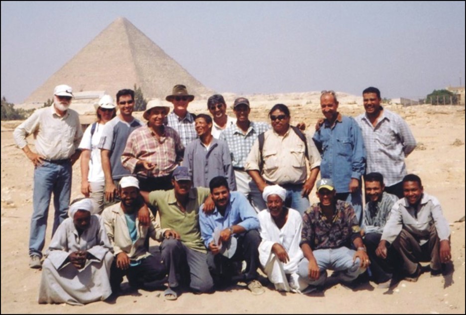
Tremaine & Associates would like to acknowledge the 2003 field team, including John Lopez, Mark Armstrong, Maggie Trumbly, Randy Yonemura, Rod Sorenson, and Ken Lajoie. The home team included Dr. Yi Liao, Shannon DeArmond, and Mike Pesses. We also want to thank Dr. Mark Lehner, Ana Tavares, and Dr. MaryAnne Murray of AERA; Dr. Zahi Hawass of the Supreme Council of Antiquities in Egypt; Terry Garcia, National Geographic; Amir Hassan of the American Research Center in Egypt; and a half-dozen Egyptian workers whose names have been lost over time. We also acknowledge Vitaliy Selyuzhitskiy for his re-examination of the data in 2023 and Kirby Page-Schmit for his help pulling together the numerous publications reporting on the archaeological findings over the past 20 years and his assistance with the first draft.
References
Amara, Dalia, and Soha Bahgat, 2020 A Successful Public-Private Partnership Model for Attraction Site Management and Protection: The Case Sutdy of the Giza Pyramids Renovation Project. The Scientific Journal of the Faculty of Tourism and Hotels, Alexandria Unviersity 17(2):1-15.
AMBRIC. 1989 Greater Cairo Wastewater Project. West Bank Project. Contract No. 27. Pyramids Area Sewers and Collectors.
AMBRIC. 1990 Greater Cairo Wastewater Project. West Bank Project. Sphinx Groundwater Study.
Bunbury, Judith 2019 The Nile and Ancient Egypt: Changing Land and Waterscapes, from the Neolithic to the Roman era. Cambridge University Press.
Bunbury, Judith, and Reim Rowe, 2021 The Nile: Mobility and Management. Cambridge University Press.
Butzer, K.W., 2001 When the Desert was in Flood: Environmental History of the Giza Plateau. AERAGRAM 5.1:3-5.
Butzer K.W., 2020 Landscapes and Environmental History of the Nile Valley: A Critical Review and Prospectus. In, The Oxford Handbook of Egyptology, edited by I. Shaw and E. Bloxam, Oxford University Press.
Dash, Glen, 2004 Seeing Beneath the Surface. Aeragram 7(1):1-11.
Hassan, Selim., Excavations at Giza Volume IV: 1932-1933. Cairo: Government Press, Cairo.
Hawass, Zahi., 1997 The Discovery of the Harbors of Khufu and Khafre at Giza. In Etudes su l’ancien empire et la Necropole de Saqqara dediees a Jean-Philippe Lauer, edited by Catherine Berger and Bernard Mathieu, pp. 245-256. Montpellier: Universite Paul Valery.
Hemeda, Sayed and Alghreeb Sonbol, 2020 Sustainability Problems of the Giza Pyramids. Heritage Science 8(8):1-28.
Kromer, K., 1978 Siedlungsfunde aus dem fruhen alten Reich in Giseh: Osterreichische Ausgrabungen 1971-1975. Vienna: Osterreichische Akademie der Wissenschaften.
Lehner, Mark, 2007 Capital Zone Walk-About 2006: Spot Heights on the Third Millennium Landscape. Giza Plateau Mapping Project Seasons 2006-2007 Preliminary Report. Giza Occasional Papers 3:
Lehner, Mark, 2009 Enigma of the Pedestal Building: Hypotheses; Desert Refrigerator? Malting Machine? Or Both? In, Beyond the Horizon: Studies in Egyptian Art, Archaeology, and History in Honour of Barry J Kemp, edited by S. Ikram and A. Dodson, pp. 189-222.
Lehner, Mark, 2010 The Giza Plateau Mapping Project. 2009-2010 Annual Report, The Oriental Institute.
Lehner, Mark, 2013 The Lost Port City of the Pyramids. AERAGRAM 14-1:2-7.
Lehner, Mark, 2014 On the Waterfront: Canals and Harbors in the Time of Giza Pyramid-Building. AERAGRAM 15(1,2: 14-23.
Lehner, Mark, 2017 Geoarchaeology of Sphinx and Sphinx Temple. In, Giza Plateau Mapping Project, 2016-2017 Annual Report.
Lehner, Mark, 2018a The Kromer Site: Fourth Dynasty Settlement Dump, in Giza Plateau Mapping Project, The Oriental Institute 2017-2018 Annual Report, pp. 87-100.
Lehner, Mark, 2018b Kromer in Context: Biography of an Ancient Dump 2. AERAGram 19(2):
Lehner, Mark, 2019 Neighborhood to National Network: Pyramid Settlements of Giza. Archaeological Papers of the American Anthropological Association 30(1):20-38.
Lehner, Mark, 2020 Merer and the Sphinx. In, Guardian of Ancient Egypt: Studies in Honor of Zahi Hawass, Volume II, edited by J. Karmin et al, pp. 895-925. Charles University Faculty of Arts.
Lehner, Mark and Ana Tavares, 2010 Walls, Ways, and Stratigraphy: Signs of Social Control in an Urban Footprint at Giza. In, Cities and Urbanism in Ancient Egypt: Papers from a Workshop in November 2006 at the Austrian Academy of Science (ed. M. Bietak et al), pp. 171-216.
Lehner, Mark, Mohsen Kamel, and Ana Tavares, 2006 Giza Plateau Mapping Project, Season 2005 Preliminary Report. Giza Occasional Papers 2. AERA.
Lepsius, C.R., 1849 Denkmaeler aus Aegypten und Aethiopien (Topographie und Archtectur, Blatt I-LXVI) [from Royal Prussian Expedition to Egypt 1842-1845]. Nicolaische Buchhandlung, Berlin.
Lopez, John, and Mark Armstrong, 2003 Preliminary Report on Electromagnetic Surveys, Giza. Unpublished manuscript prepared for Mark Lehner of AERA.
Lutley, C., and J. Bunbury, 2008 The Nile on the Move. Egyptian Archaeology 32(2):3-5.
Polywka, John, 2021 Water Transportation at Giza During Khufu Time. Accessed via website 080823, www.sectretofthepyramids.com.
Reisner, George A., 1931 Mycerinus: The Temples of the Third Pyramid at Giza. Cambridge, MA: Harvard University Press
Saleh, Abdel-Aziz, 1974 Excavations Around Mycerinus Pyramid Complex. Mitteilungen des Deutschen Institut für Ägyptische Altertumskunde in Kairo 30 (1974): 131-54
Sheisher, Hader et al., 2022 Nile Waterscapes Facilitated the Construction of the Giza Pyramids During the 3rd Millennium BCE. National Academy of Sciences.
Smyth, C.P., 1867 Life and Work at the Great Pyramid during the Months of January, February, March, and April, A.D. 1865. Vol. I, Edinburgh: Edmonston and Douglas.
Tallet, Pierre, 2017 Les Papyrus de la Mer Rouge I: Le ‘journal de Merer’ (Papyrus Jarf A et B). MIFAO 136. Cairo, Institut Francais d’ Archeologie Orientale.
Vyse, Howard, and J.S. Perring, 1842 Operations Carried on at the Pyramids of Gizeh in 1837, Vol. III. London, John Weale, H. Holborn, and G.W. Nickisson
Wetterstrom, W. and Anna Tavares, 2008 Lost City Site, Flooded! AERAGRAM 9.1:5-6. Boston, MA: Ancient Egypt Research Associates, Inc.
Wilkinson, I. Gardner, 1858 Handbook for Travellers in Egypt Including Description of the Course of the Nile to the Second Cataract, Alexandria, Cairo, the Pyramids, and Thebes. John Murray, Albemarle Street, London.
Witsell, Ali, 2018 Kromer 2018: Basket by Basket. AERAGRAM 19(1):2-9.
Yilmaz, Yildirim and Rehab El Gamil, 2019 The Role of Heritage Impact Assessment in Safeguarding World Heritage Sites: Application Study on Historic Areas of Istanbul and Giza Pyramids. Journal of Heritage Management 3(2):127-158.
Authors’ Bios
Kim Tremaine
Kim Tremaine has a Masters in Cultural Resources Management from Sonoma State University and is a doctoral candidate at the University of California at Davis. She has acted as Principal Investigator and Program Manager for Tremaine & Associates, an archaeological consulting firm, for the past 30 years. She specializes in historical research, geoarchaeological methods, environmental sequence stratigraphy, and the use of contextual analyses to strengthen interpretations of geophysical data.
John Lopez
John Lopez completed his graduate education in Cultural Resources Management at Sonoma State University researching the application of Genetic Algorithms & Complex Adaptive Systems to human behavior and archaeological landscape formation. He co-founded Tremaine & Associates in 1994. Since then, he has been involved developing a mobilized geophysical technology for non-destructive subsurface investigations. In addition to archaeological applications, he has applied this technology to transportation projects, tunnel detection, contaminated landfills, and levee integrity studies.
