
By Abdelmonem Mohamed1, Hanan Genidi1, Abdelhamid Elbshbeshi1, Ahmed Gomaa1 and Gad El-Qady1
1National Research Institute of Astronomy and Geophysics (NRIAG), Helwan, Cairo, Egypt.
Abstract
El-Kadi House “Judge’s House” is one of Egypt’s most important archaeological sites that was planned to develop within sustainable development strategy 2030. El-Kadi House is located in Historic Cairo or Islamic Cairo, one of the most historic densest sites in Egypt and the whole Islamic world; it has had rich history and heritage since its foundation in the early period of Islam. Moreover, it is close to the Ancient Egyptian spots of Giza and Memphis. It suffers from various serious issues; the most important problem is the underground water which threatens its long preservation. Based on the importance of the site and the conditions to which it is exposed. So, it becomes necessary to document it to preserve the monument by using progressive 3D technologies and more efficient mapping solutions. Documenting heritage structures with considerable cultural significance in society can be done differently. Recently, three-dimensional Terrestrial Laser Scanning (TLS) has been considered the best modern technology due to its completeness, simplicity, speed, and accuracy. In this work, Trimble Tx6 was used to capture and record the color information of the geometric data of El-Kadi House. This technological method can generate a three-dimensional colored visualization model of El-Kadi House.
Introduction
El-Kadi House is located on El-Moez Street, one of the most famous streets in Old Historic Cairo (Fig. 1). This site, added to the UNESCO World Heritage List in 1979, is the world’s largest open-air museum of Islamic monuments. Moheb El Din Abu El-Tayeb Hall, Maqaad Emir Mamay El-Sayfi, and El-Kadi House Gate are historical monuments located on El-Moez Street. These monuments were built in 1496 AD. The house was badly reconstructed in 1847. Although the major part of the building is in a ruinous state, there are a number of beautiful poetic inscriptions all around the hall (Ministry of Tourism and Antiquities, 2019). El-Kadi House consists of three parts: the Moheb El Din Abu El-Tayeb Hall used on rainy days, the Maqaad Emir Mamay El-Sayfi Hall used on sunny days, and the El-Kadi House Gate which dates to the fifteenth century (Fig. 2). The house was built during the Mamluk period and served as the El-Mahkamah or the court of Kadi El-Kudah. Long ago, it played a major role in matters of justice and law in Egypt. It was responsible for taking part in some tasks similar to Dar Al-Efta’s such as foretelling the beginning of the Muslim calendar month with the sighting and reporting of the crescent (Antoniou et al., 1980; Sutton and Fahmi, 2002).
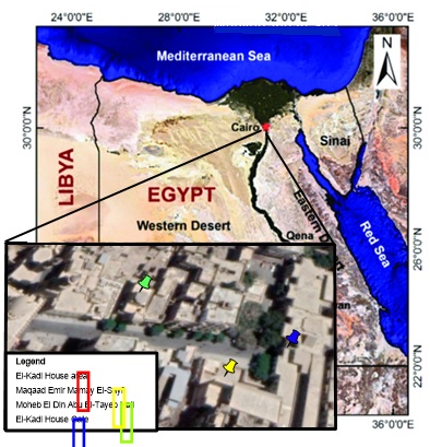
Figure 1. Location map of El-Kadi House area in Old Historical Cairo, Egypt.
On the other hand, a European-style conservation organization was established in Cairo that changed the zone and its built environment. The house was badly reconstructed in 1847 and restored in 2001 to regain its former beauty (El-Habashi, 2001 ;AlSayyad et al., 2005; Sanders, 2008: Fig. 3).
Over the last decade, the quick development in available technological support and the expanding field of their application has delivered modern opportunities which challenge ancient outlines of reference that have remained unaltered over time. Actually, laser scanning has an exceptional potential for promoting a revolution in recording and documenting archaeological evidence and its broadcasting. Cultural heritage represents a nation’s treasures from small artifacts and heritage items to large landscapes and ancient historical buildings including archaeological sites. In the last decade, documenting all these important cultural data has been of great interest through remote sensing and the International Society of Photogrammetry and to preserve cultures and the historical heritage of countries (Vosselman, and Maas, 2010).
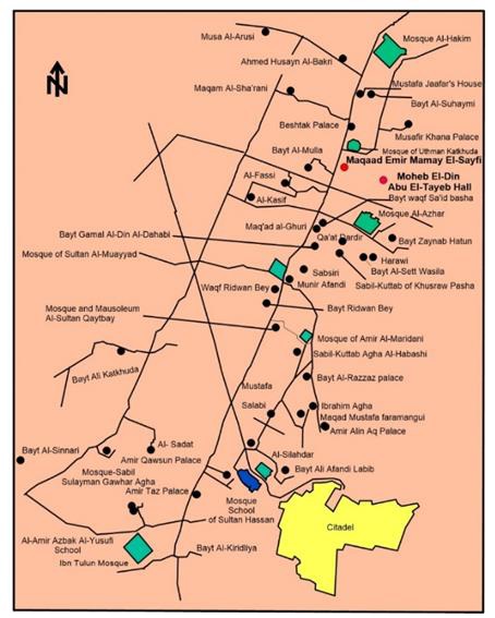
Figure 2. Map of palaces and private residences in Old Historic Cairo, overlaid with present road network and showing with the red circle symbol location of Moheb El Din Hall and Maqaad Emir Mamay El Sayfi. Modified after Wikipedia.
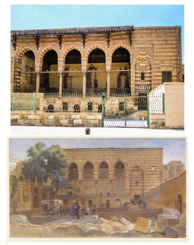
Figure 3. Maqaad Emir Mamay El Sayfi in current status and old painted by Frank Dillon, 1869, (Victoria & Albert Collections, 2008).
The laser scanner has become the most applied and effective device in conjunction with image-based documentaries to preserve cultural heritage and reconstruct the three-dimensional models from these data because of the rapid data that three-dimensional scanners can capture. Laser scanner devices can record three-dimensional data of massive object points with a relatively short period and accurate results. In order to acquire this data, the laser transmitter sent a laser beam to scan the object surface with a certain specification to fulfill the scan need and the range accuracy (Abed, 2012).
Terrestrial laser scanning techniques have an essential role for cultural heritage applications, including the traditional preservation attitudes, by providing high-resolution three-dimensional models of the scanned sites or for documentary purposes. Moreover, it can be advanced to apply accurate measurements and monitor deformation in cultural buildings to preserve them from destruction due to time effect.
Geodetic laser scanner techniques are based on production precise measurements, and highly intensive three-dimensional point cloud data analysis. It does not always need to go through hard post-processing and modeling, which takes a long time. This innovative approach is based on the engineering perspective goals to provide valuable data for structural analyses.
Based on this purpose, the paper presents to document 3D mesh model, preserve these buildings, and monitor deflection and deformation in El-Kadi House required a special process to resolve the terrible problems that faced the study area, especially the underground water, humidity, and urban development. As well as the difficulties that faced the teamwork keep the targets for six days without removing them until finalized surveying. Also, selecting the best stations to place the TLS, transferring the TLS into the upper floors and rooms. So, it is so necessary to find a practical solution to apply the documentation.
Methodology
The methodology presented is applied using a laser scanner “Trimble TX6” with a built-in high-resolution digital camera for color information. In this case study, the data was collected and organized by four main stages; the first stage began with planning the study area’s survey and visualizing the places of scan stations before starting the on-site stage. The second stage was establishing the control points on facade of buildings surveying from Global Navigation Satellite System (GNSS). The third stage was using the TLS to scan the house from various heights using flat targets. The final stage was to produce a 3D model to document and preserved the study area. These stages have been applied and explained as follows.
TX6 is a terrestrial mapping system that can scan at 500,000 points per second while maintaining scan quality and range. Integrated HDR camera to colorize scans, simple onboard interface with no complicated settings, built-in WLAN for remote control from any mobile device. The range of TX6 is from 80 to 100 meters but can be extended to 120 meters. Data from the Trimble TX6 loads directly into Trimble RealWorks© and Trimble Scan Explorer© Software for making registration and extraction 3D model, and produce powerful deliverables or export data to AutoCAD© Software, as shown in (Fig. 4).
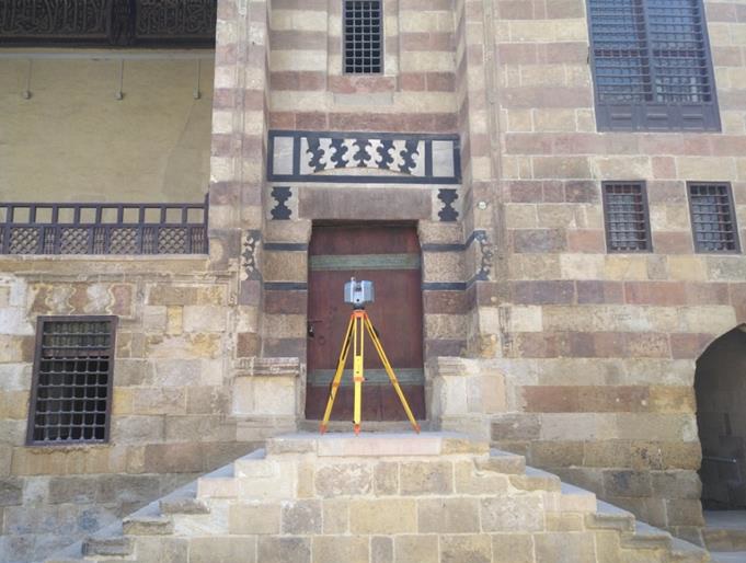
Figure 4. Terrestrial Laser Scanner (TLS) TX6 in action surveying of Maqaad Emir Mamay El Sayfi.
GNSS surveys require different planning, execution, and processing techniques. The optimum planning of GNSS surveying has to consider several parameters such as site or satellite configurations, satellites status, and the number and type of receivers used. The measurements will be performed using the GNSS receiver’s type Trimble R-8 to calculate the coordinates for control points around the site to produce a geo-referenced model for the site (Table 1). Baselines analyses were processed using the Trimble Business Centre software package and other programs for adjustment and deformation parameters calculations. The reference stations are tied to International GNSS Service (IGS) stations to compute the precise coordinates in the International Terrestrial Reference Frame (Fig. 5).
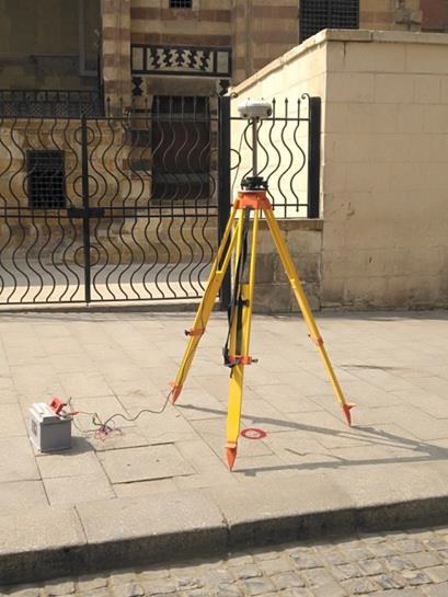
Figure 5. Trimble receiver R 8 during measuring the control points in front of Maqaad Emir Mamay El Sayfi.
The total station is optical/electronic equipment that employs an electronic transit theodolite combined with an Electronic Distance Meter (EDM) for building construction and modern surveying purposes. Moreover, it is combined with electronic data accumulators, microprocessors, and storage systems. The device is used to determine the slope distance between an item and the instrument and vertical and horizontal angles. This microprocessor unit allows the processing of data gathered to determine the point coordinates, horizontal distance, and decreased point level. During the Trimble R-8 measuring the control points, the flat target measured by Trimble Total Station S-5 to get the accurate coordinates (northing, easting, and elevation, or X, Y, and Z) for each point at the final model. The data from the total station can be transferred to a computer, where specific software is used to calculate the results and produce a map of the surveyed region.
The team working on this research has planned the workflow that follows to explain and assist them in creating a 3D point cloud model for El-Kadi House buildings. Every one of these stages, the researchers faced a various kind of issue related to documentations, and techniques being employed. The essential steps on 3D point cloud modeling by laser scanning are briefed as follow (Figs. 6 and 7).
Trimble laser scanner has a field of vision up to 360 x 280 and can accumulate data up to 120 meters away with an angular resolution of 0.004. These produce point clouds with coordinates X, Y, and Z besides the intensity of reflectivity every reflected laser pulse. It was fundamental for geo-referencing the data collected using the Laser Scanner TX6, set up an array of retro reflectors (Black and White, and sphere targets) to be utilized as control points. These control points have been measured by a total station (Trimble S-5) in a local coordinate system set up for the duration of the survey. The control points are utilized to connect individual scans from numerous scanner locations into a single project, converted into a world coordinate system set up for the duration of the survey. The control points are utilized to connect individual scans from numerous scanner locations into a single project, converted into a world coordinate system afterwards.

Figure 6. Modeling process through multiple steps.
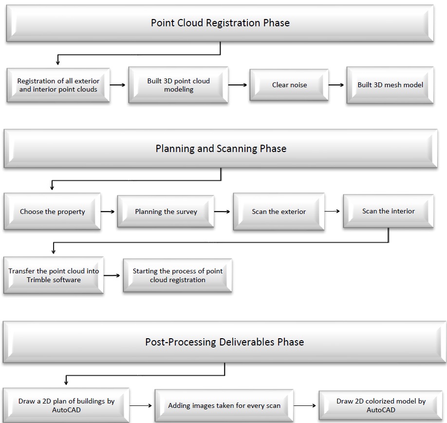
Figure 7. Schematic diagram of the methods employed in this study.
Firstly, Moheb El-Din Hall consists of three floors that are covered by forty-six scans, the first and second scans are exterior on the façade of the building, these scans depending on black and white flat target that measured by total station to create geo-reference model. The position of the first and second scans are measured by GPS Trimble R8 to establish the control point (A1and A2), then the total station used to survey black and white flat target from the position A1 and A2 (position of first and second scans). The first scan contains three black and white flat targets, the second scan contain two black and white flat target and three spherical targets. The spherical target in the second scan used to make overlap for the third scan and so on. it’s like chain. In Moheb El-Din Hall, 180 sphere targets are used for all scans, all flat and spherical targets are used for registration (Fig. 8).
On the other hand, Maqaad Emir Mamay El-Sayfi was covered by sixty scans; two the first and second scans are exterior on the façade of the building, these scans depending on black and white flat target that measured by total station to create geo-reference model. The position of the first and second scans are measured by GPS Trimble R8 to establish the control point (B1and B2) which measured from the total station with the coordinates obtained in Table 1, then the total station used to survey black and white flat target from the position B1 and B2 (position of first and second scans). The first scan contains three black and white flat targets, the second scan contain three black and white flat target and three spherical targets. The spherical target in the second scan used to make overlap for the third scan and so on, it’s like chain. In Maqaad Emir Mamay El-Sayfi, 200 sphere targets are used for all scans; all flat and spherical targets are used for registration. Finally, El-Kadi House Gate was covered by four scans and was registered using ten sphere targets. After finishing the fieldwork data acquisition, all scan data have been registered into one-point cloud model.
Table 1. Four control points are measured with coordinates X, Y and Z.
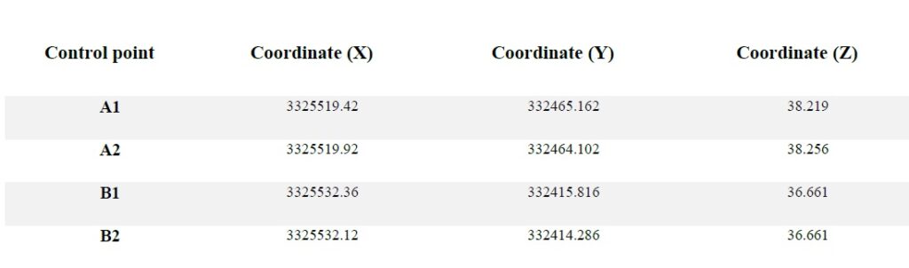
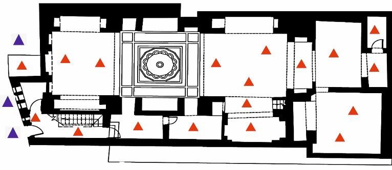
Figure 8. Distribution of scan stations of Moheb El Din Hall, ground floor (red triangles represent inside and blue triangles outside scan stations).
Results
The results have been processed, analyzed, and validated against data delivered from field Acquisitions to demonstrate the validity of the applied routine as stated in the following subsections. Point cloud registration is the process of finding a spatial transformation (e.g., scaling, rotation and translation) that aligns two or more point clouds into a single best fit point cloud model. The integration depends on two methods; Cloud to cloud registration and Target based registration. Cloud to cloud registration uses overlapping scan data to register two or more point clouds. Also, using the GPS (control points) will allow all scans from every position to reference in a coordinate project system (Cheok et al., 2000). In this work, both methods of registration will be used. On the outside of El-Kadi House, then all targets are measured using Trimble Total Station S5.
In Moheb El Din Hall and Maqaad Emir Mamay El-Sayfi, the total station used to estimate the precise coordinates for the first and second scans which contain Black and White flat targets to use them as geo-reference points. After that, spherical targets were used to link the remaining scans (Fig. 9). The gate of El-Kadi House was registered using only spherical targets. Trimble Real works©11.2 was used to register all scans for El-Kadi House. After final registration of all scans, the resulting 3D point cloud model created has an accuracy of 3mm. The registered point cloud may be viewed in different modeling software, such as Autodesk Revit, 3-DMAX, Sketch Up and AutoCAD (Mills, and Barber, 2004; Murphy, and Kevin, 2012; Akash Singh, and Lingeshwaran, 2017).
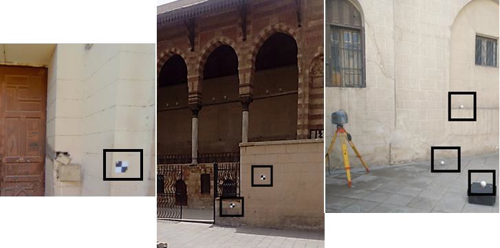
Figure 9. Black and white flat targets and Spherical targets specified within black squares that placed on site’s facades.
In order to process the laser scanning data, the scans were removing unwanted or scattered points within each individual or combined scan using Trimble Realworks© Software. Then the registered point clouds were converted into a mesh and the holes automatically filled. Finally, the archaeological sections were extracted in order to be digitized to have geo-referenced model (Figs. 10, 11 and 12). After registration, the scan explorer used to extract point clouds to create different models as 2D plan, point cloud, Ortho-images and mesh models (Table 2).
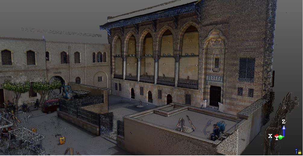
Figure 10. 3D register point clouds in Maqaad Emir Mamay El Sayfi.
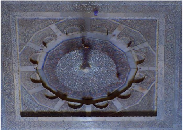
Figure 11. Colorized point clouds water fountain in the middle of Moheb El Din Abu El Tayeb Hall.
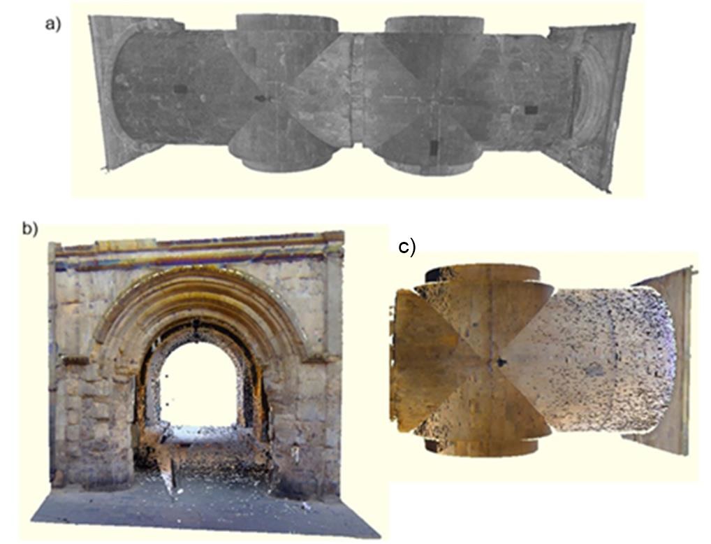
Figure 12. Extracted portions of the El Kadi House Gate and the corridor point cloud. a) Plan view in perspective for the corridor without color from exterior top view, b) Elevation of gate view with color mapped. c) Portions of the corridor after adding color.
Table 2: Some information used for extracting 3D model of Moheb El-Din Abu El-Tayeb Hall, Maqaad Emir Mamay El-Sayfi, and El-Kadi House Gate.
It is important to keep track of unwanted objects within the scan scene while maintaining visual access to reference points. Moving and stationary objects such as people, vehicles, and furniture can obscure certain important features to be scanned and will add noise, unwanted point data, to the scan that must be filtered and removed from the final point cloud. One of the most difficult and necessary parts of post-processing point clouds is cleaning (Marshall-Ponting et al., 2009; Tang, 2010; Guillen et al., 2016).
According to the objectives of the project, the data collected can be post-processed in several ways. The first product derived from the collected point cloud is a detailed 3D point cloud model of El-Kadi House and the surrounding area. For triangulation of a mesh model, it is essential to reduce the total number of points by resampling the data with a defined lower resolution. The first resampling reduced the level of detail to 1cm. Roughly 31 million triangles are created in this mesh model. Triangulation of the point clouds can be done through Trimble Realworks© Software to create 3D mesh models for the buildings at the sites (Figs. 13, 14, and 15).
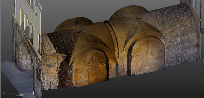
Figure 13. 3D Point cloud and mesh model for El Kadi House Gate.
The mesh model was sliced into many layers to accurately measure the structure’s details. The number of slices should be increased to enhance the architectural drawings to get accurate data for drawings. After this step, the data was exported to 3D-Max (Fig. 16). In this study, a common method was used to delineate traditional architectural lines drawings of plans, elevations, and sections. Exporting the point cloud allowed us to trace the plans reflecting the same measurements captured in the laser scan. The team work started to export the point clouds as DWG or DXF formats from Trimble Realworks to Autodesk AutoCAD Software to draw the facades with Islamic architecture, doors, windows, poles, and woods.
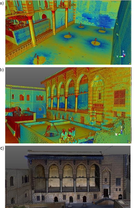
Figure 14. Maqaad Emir Mamay El Sayfi. a) Interior perspective view of point cloud with intensity mapping, b)Exterior perspective view of point cloud with intensity mapping, and c) Exterior view of cleaned point cloud with color data mapped.
The 2D plans were drawn with consideration the true dimensional. The output shows each detail as plan, section, and elevation for the interface of Maqaad Emir Mamay El-Sayfi, El-Kadi House Gate, and Moheb El-Din Abu El-Tayeb Hall respectively (Figs. 17, 18, and 19).
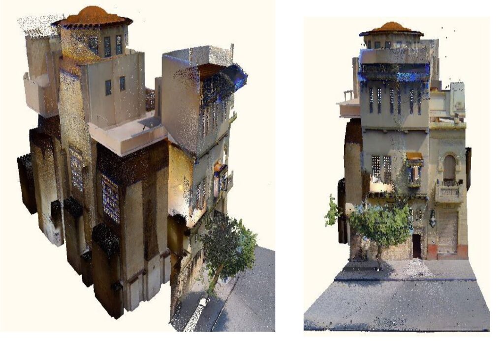
Figure 15. Perspective views of the Moheb El Din Abu El Tayeb Hall color mapped and cleaned point cloud.
Figure 16. Isolated point cloud of column from Maqaad Emir Mamay El-Sayfi. a) True color, b) gray scale, c) Classified by height, and d) Intensity color map.
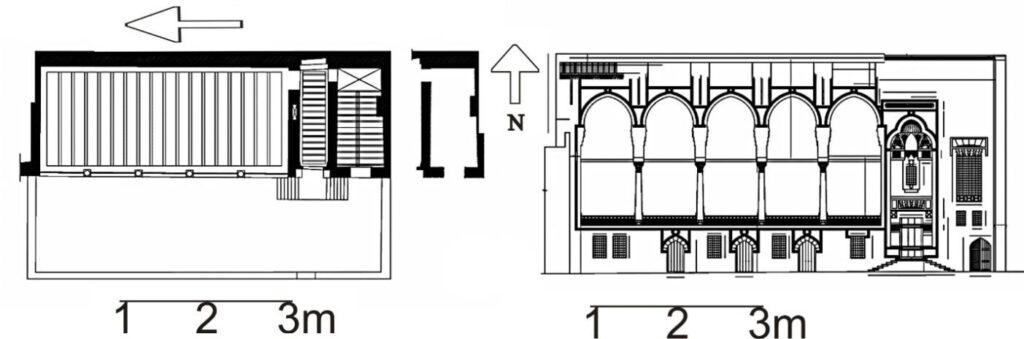
Figure 17. 2D drawing of a plan, and an elevation of an internal courtyard wall of Maqaad Emir Mamay El Sayfi.
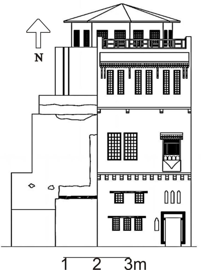
Figure 18. 2D drawing of an elevation of Moheb El Din Abu El Tayeb Hall façade.
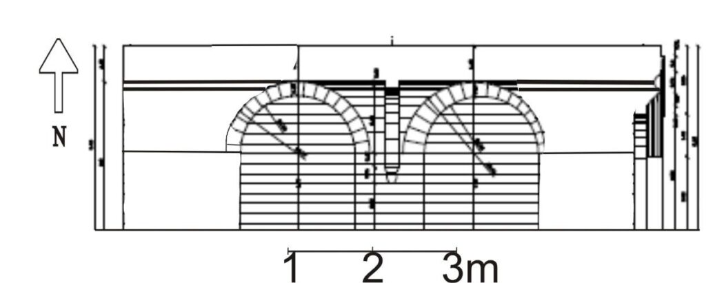
Figure 19. 2D longitudinal section of El Kadi House Gate.
Conclusions
Using the modern surveying technique of terrestrial laser scanning permitted the creation of three-dimensional point clouds, mesh models, and two-dimensional drawings for Moheb El_Din Abu El-Tayeb Hall, Maqaad Emir Mamay El-Sayfi and El-Kadi House Gate. The 3D model contains verifiable accuracy and color representing the reality of the existing structure. Now we can preserve within this documentation the structure’s existing conditions captured in 2019 and help facilitate future rehabilitation efforts.
In 1979, UNESCO called for preserving and documenting the monuments of historical Cairo to become one of the critical areas of both cultural and historical significance in Egypt. Recently, the government paid more attention to conserving historical buildings of Egypt. So, the department of Geodynamics at the National Research Institute of Astronomy and Geophysics (NRIAG) recognized that and started to document the most important monument threatened by destruction. Several researchers and volunteers were involved in carrying on this research project. So that the documentation processes could convince stakeholders about the importance of these old buildings in society. This would also generate economic activities once the documentation processes were completed.
The heritage buildings, such as El-Kadi House, offered the opportunity to study and preserve these types of buildings using a suitable method through this study in Egypt. Moreover, this research outcome opts to comprehend documenting heritage buildings’ considering the complications in terms of design and preservation. Additionally, employing these mentioned methods, historically significant buildings can be demonstrating critical roles for the betterment of the economy and can uphold the history of the country and building virtual museums for tourism industry.
Acknowledgement
The authors would like to thank the Team work. Also, more thanks to National Research Institute of Astronomy and Geophysics for financial assistance and the permission to study the El-Kadi House.
References
Antoniou, J., Bianca, S., Welbank, M., El-Hakim, S., and Lewcock, R., (1980). The Conservation of the Old City of Cairo. Paris: United Nations Educational, Scientific and Cultural Organization.
Sutton, K., and Fahmi, W., (2002). The Rehabilitation of Old Cairo. Habitat International 26: 73–93. doi:10.1016/ S0197-3975(01)00034-0.
El-Habashi, A., (2001). “Athar to Monuments: The Intervention of the Comité De Conservation Des Monuments De L’art Arabe.” PhD Dissertation, University of Pennsylvania.
AlSayyad, N., Rabbat, N., and Bierman, I., (2005). Making Cairo Medieval. Lanham: Lexington Books.
Sanders, P., (2008). Creating Medieval Cairo: Empire, Religion, and Architectural Preservation in Nineteenth-Century, Egypt. Cairo: American University in Cairo Press.
Victoria and Albert Collections, (2008) El Mahkemeh or Court of the Cadi Cairo,: http://collections.vam.ac.uk/item/O143180/el-mahkemeh-or-court-of-watercolour-dillon-frank-ri/. Accessed Oct., 2021
Vosselman, G. and Maas, H, (2010). G: Airborne and terrestrial laser scanning Scotland, UK: Whittles Publishing. File:Muizz Street-ar.gif., Wikimedia modified by bassem, (2016), https://commons.wikimedia.org/wiki/File:Muizz_Street-ar.gif Accessed Oct., 2021
Abed, F.M., Mills, J.P., and Miller, P.E., (2012). Echo amplitude normalization of full wave form airborne laser scanning data based on robust incidence angle estimation, IEEE Transactions on Geoscience and Remote Sensing, 50 (7), 2910 – 2918.
Cheok, G.S., Lipman, R.R., Witzgall, C., Bernal, J., Stone, W.C., (2000). Field demonstration of laser scanning for excavation measurement. Proc. 17th ISARC/CIB/IEEE/IFAC/ IFR Int. Symp. Autom. Robot. Constr. https://doi.org/10.22260/isarc2000/0077.
Mills, J., and Barber, D., (2004). Geomatics techniques for structural surveying. J. Survey Eng. 130, 56–64. https://doi.org/10.1061/(ASCE)0733-9453(2004)130:2(56).
Murphy, Kevin P., (2012), Machine learning: a probabilistic perspective (Adaptive computation and machine learning series) includes bibliographical references and index. ISBN 978-0-262-01802 9.
Akash Singh, B., Lingeshwaran, N., (2017). Seismic study of GPS RC framed structure supported on raft foundation. Int. J. Civ. Eng. Technol. 8, 467–476.
Marshall-Ponting, A., Arayici, Y., Khosrowshahi, F., Dr Sas Mihindu, (2009). Towards implementation of building information modelling in the construction industry. Collibration and Integration in Engineering, Mangement, and Technology, Fifth International Conference on Construction in the 21st Century (CITC-V), May 20-22,2009, Istanbul, Turkey . 1342–1351. https://doi.org/10.13140/2.1.3776.6080. Accessed Aug., 2021
Guillen, A.J., Crespo, A., G_omez, J., Gonz_alez-Prida, V., Kobbacy, K., Shariff, S., (2016). Building information modeling as assist management tool. IFAC-papers on line 49, 191–196. https://doi.org/10.1016/j.ifacol.2016.11.033. Accessed Sep., 2021
Tang, P., Huber, D., Akinci, B., Lipman, R., Lytle, A., (2010). Automatic reconstruction of as-built building information models from laser-scanned point clouds: a review of related techniques. Autom ConStruct. 19, 829–843 https://asu.pure.elsevier.com/en/publications/automatic-reconstruction-of-as-built-building-information-models- Accessed Sep., 2021
Ministry of Tourism and Antiquities, (2019), Al-Mu’izz Street, https://egymonuments.gov.eg/archaeological-sites/al-muizz-street/ Accessed Mar. 2022
Authors’ Bios
Abdelmonem Sayed Mohamed
Professor of Geophysics and Geodesy in the Geodynamic Department, NRIAG from 2008. B. in Geology from Faculty of Science, Assiut University (1982). M.S. from Faculty of Science Al-Azhar University (1992). Ph. D. from the Hungarian Academy of Science (1997). Diploma in Risk Modeling and Society from International Institute for applied systems analysis (YSSP) Young Scientists Summer Program, Laxenburg, Vienna, Austria (2004). A grant from the German Academic Exchange Service (DAAD), Institute of Geodesy, Stuttgart University, Germany (2003, 2007 and 2011). Teaching in Higher Technological Institute in Tenth of Ramadan from 2008 to 2011.
Hanan Genidi
Dr. Hanan Genidi takes immense pride in her role as a researcher at the National Research Institute of Astronomy and Geophysics. Her journey in the field of geophysics has been an exciting endeavor, tightly interwoven with the institute’s tireless pursuit of unraveling the Earth’s intricacies. Her academic Ph.D. research included harnessing the power of GPS and InSAR data for the crucial task of monitoring crustal deformation. While her doctoral research forms a cornerstone of her career, she is equally enthusiastic about contributions beyond academia.
Ahmed Gomaa
Ahmed received the B.Sc. degree (Hons.) in Electronics, Communications, and Computer engineering, in 2009, the M.Sc. degree from Cairo University in Electronics, Communications, and Computer Engineering, Cairo, Egypt, in 2015, and the Ph.D. degree from the School of Electronics, Communications, and Computer Engineering, Egypt-Japan University of Science and Technology (E-JUST), in collaboration with Kyushu University, in 2020. From 2009 to 2015, he was a Teaching Assistant at Electronics and Communication Department, IAET. In 2015, he joined National Research Institute of Astronomy and Geophysics (NRIAG), Egypt. In February 2019, he joined the Laboratory for Image and Media Understanding (LIMU), Kyushu University, Japan, as a Special Research Student. In October 2022, he joined the Laboratory for Image and Media Understanding (LIMU), Kyushu University, where he held a POST-DOC Fellowship. He is currently an Assistant Professor with the National Research Institute of Astronomy and Geophysics (NRIAG). His current research interests include Image & Video Processing, Computer Vision, GNSS, Remote Sensing, Wireless Sensor Networks, Intelligent transportation systems, and Object Detection & Tracking.

Abdelhamid Elbshbeshi
Dr. Abdelhamid Elbshbeshi earned his MSc in Geophysics from the University of Mansoura, Egypt. Currently, he is in the final stages of completing a PhD in Geophysics at the same university. He serves as an assistant researcher at the National Research Institute of Astronomy and Geophysics. With over 9 years of dedicated experience in laser scanning techniques (both mobile and terrestrial) and geophysical methods, he continuously enhances his skills in this domain. His expertise is complemented by a keen awareness of ongoing technological advancements. He has also contributed to the field through the publication of multiple papers in peer-reviewed journals.
