
By Mustafa Saribudak1
1Environmental Geophysics Associates (EGA), Austin, Texas
Abstract
During December 18-20, 2018, Main Barton Spring in Austin, started discharging plumes of turbidity (sediment) flows into the Barton Springs swimming pool (BSSP). Within couple days, the source was found by the joint efforts of the City of Austin Watershed Protection Department and the Barton Springs Edwards Aquifer Conservation District, to be a geothermal drilling site at a residential neighborhood, which was located about 4,000 ft (1,220 m) to the southwest of the swimming pool. During the drilling operation ten closed-loop geothermal wells were drilled into the karstic Edwards Aquifer. A draft summary report concluded that a void was encountered at a depth of 240 ft (73 m) and was likely connected to a karst conduit flowing to the BSSP. The report approximately projected the groundwater flow direction and pathway from the drilling site into the BSSP area. The estimated pathway corresponds to previously located multi-method geophysical anomalies to the south of the swimming pool. Resistivity anomalies indicate conduit and fault-like features in the study area, which strongly suggest that the groundwater flow from the drilling site follows the conduit anomalies of elliptical and circular shapes further to the northeast into the geophysical study area; then it bends to the north due to a newly identified potential fault, where the swimming pool is located. The correlation of the geophysical data with the groundwater flow direction carrying the sedimentary plume in the vicinity of the swimming pool appears to be well established.
Introduction
Barton Springs is a major discharge site for the Barton Springs Segment of the Edwards Aquifer and is located in Zilker Park in Austin, Texas. Barton Springs is a perennial karst spring complex that has an average flow of about 60 ft3/s (1.73 m3/s) and sustains recreational (Barton Springs Swimming Pool, BSSP) and environmental flows (Hunt et al., 2019). The Main Barton Spring discharges into the Barton Springs pool from the Barton Springs fault and from a cave or conduit. Additional springs in the pool issue from fissures and gravel-filled solution cavities on the floor of the pool west of the fault. The Barton Springs Fault trends to the northeast and down-to-the-southeast motion of about 100 ft (30m). The thin-bedded limestone unit on the northwest side of the fault is the regional dense member (Person Formation) of the Edwards Group, and limestone unit on the southeast side (downthrown) is the Georgetown Formation (Figure 1). Northeast of the Main Spring and along the Barton Springs Fault is Eliza Spring that is outside of the BSSP but is the largest habitat for the endangered Salamander species. Dye tracing has established a hydrologic connection between the Main Spring and Eliza Spring.
The purpose of this geophysical note is to integrate the results of previous geophysical work with the new information from the sediment-plume release to better characterize groundwater flow in the vicinity of the Barton Springs complex and to ground truth the geophysical data.
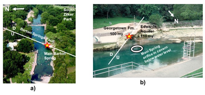
Figure 1. a) Aerial view of the Main Barton Spring, Barton Springs fault and the South Zilker Park in south Austin, b) Barton Springs fault crossing the pool which juxtaposes the Georgetown Formation and the member of the Edwards Aquifer (Regional Dense Member of the Person Formation). Note that the groundwater flows into the pool at the fault contact between the two geological units (red/yellow star) and an orifice beneath the pool water.
Turbidity Event
Between December 18 and 20, 2018, three separate, discrete, and visible discharges of turbidity from Barton Springs into Barton Springs Pool were observed. The discharges caused unusual turbidity and as a precaution the City of Austin closed the pool for recreational use on December 19, 2018 (Figure 2). The Eliza Spring was also affected by the turbidity flow. City of Austin staff worked with the Barton Springs/Edwards Aquifer Conservation District (BSEACD) to identify the likely source of turbidity as sediment produced from the drilling of boreholes for a geothermal system for heating and cooling for a residential site along Paramount Avenue, which is located 4,000 ft to the southwest of the BSSP (a report of BSEACD, 2019, see Figure 3).
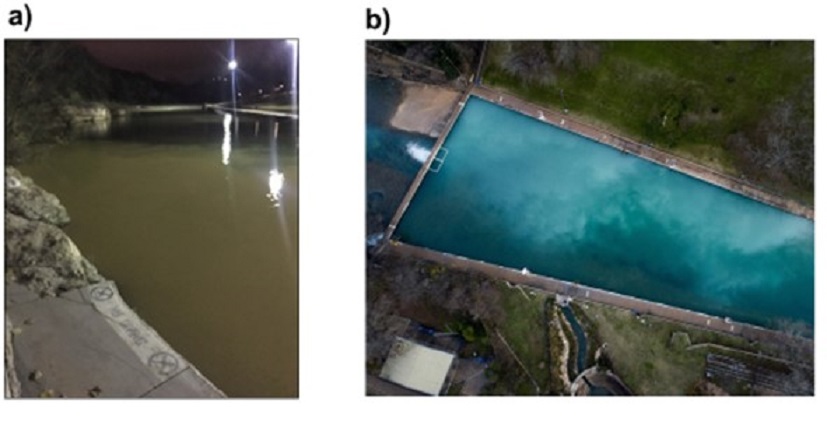
Figure 2. a) Turbidity plume visible at Barton Springs Pool–photo taken by City of Austin (CoA) staff at 12/27/18 ~8pm. The plumes of sediment produced from the drilling three boreholes (out of ten) filled the swimming pool, rendering a cloud-like appearance to the pool water. b) Drone footage of the white sediment plume in Barton Springs Pool in December 19, 2018 (Sydow et al. 2020).
The report concluded that a void (cavernous porosity) was encountered at a depth of 240 ft (73 m) just above the water level, and was assumed to be connected to a karst conduit flowing to the pool. At this location the Edwards Aquifer is in a confined state. The report approximately projected the groundwater flow direction and pathway from the drilling site into the BSSP on a local geological map (Figure 3). The map indicates that the groundwater flow direction intersects with the area where multi-method geophysical surveys were conducted.
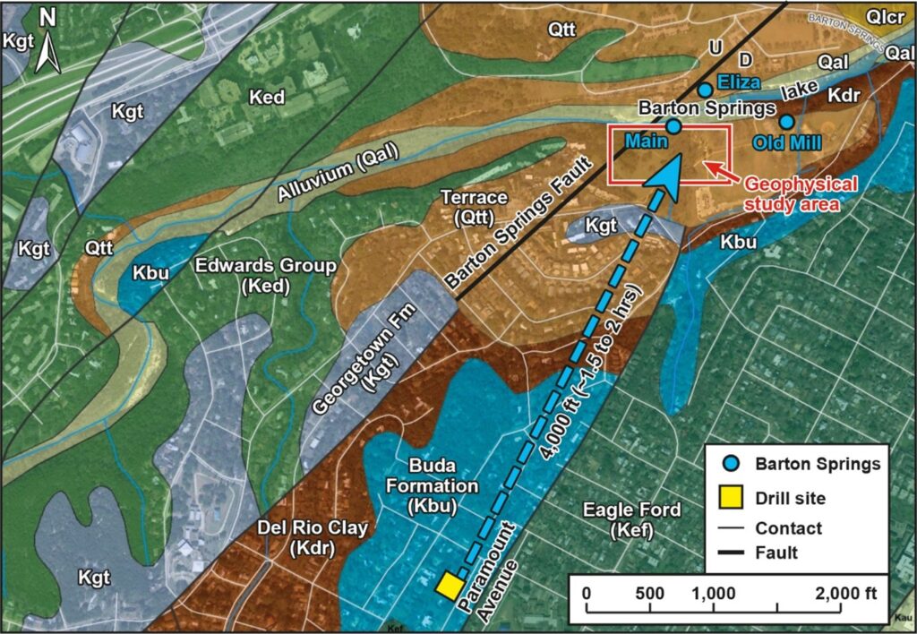
Figure 3. Geologic base map showing general flow path from the drill site to the Barton Springs swimming pool. Sediment arrival was up to 1.5 hours (64,000 ft/day or 12 mi/d) from the drill site to Barton Springs. Geological map modified from City of Austin. The figure is a courtesy of Brian Hunt. Note that the groundwater flow direction is projected (a dashed blue line) into an area where extensive geophysical data was collected in previous years. Locations of three springs (Main Barton, Eliza and Old Mill) are also shown in the NW section of the map.
The City of Austin of Watershed Department (WPD) is the sole organization that maintains a spill response plan to protect Barton Springs, one of the largest springs in the state that also functions as a municipal swimming pool, endangered species habitat, and well-studied karst research site. From December 18–20, 2018, three discrete sediment plumes of unknown origin emerged from Main Barton Spring and Eliza Spring, presenting an atypical spill scenario. Unlike the majority of spills, where staff respond to a known location, pollutant, and spill volume, WPD responders and staff at the Barton Springs Edwards Aquifer Conservation District (BSEACD) had to work backward from evidence at the springs to identify the plumes’ source (Sydow et al., 2020). Results are also summarized on a geological cross section (Figure 4), which depicts drilled well depths intersecting the water table. The cross section also indicates that the drilled water wells are within the confined aquifer zone, and the groundwater flows towards the Main Barton Springs area from this karstic zone where it becomes an unconfined aquifer (Figure 4).
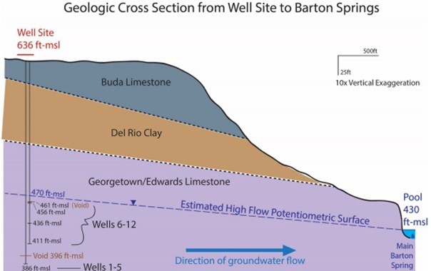
Figure 4. Geologic Cross Section from the Well Site to Main Barton Spring. Cross section depicts drilled well depths at the site intercepting the water table (Taken from Sydow et al., 2020). Note that the groundwater flow is in a confined type aquifer at the well site, and it becomes an un-confined one near the Main Barton Spring.
Previous Geophysical Work
Integrated geophysical studies have been conducted to the south of the BSSP (south Zilker Park) in the last 10 years (Saribudak et al., 2013, Saribudak and Hauwert, 2017). The studies resulted in the discovery of significant geophysical anomalies related to conduits and structural features. Correlation of some of the conduit anomalies with the turbidity data information is discussed below.
Discussion
Multiple geophysical methods were conducted in and around the Barton Springs swimming pool during the last decade and included 2D/3D resistivity imaging, self potential (SP), GPR, seismic refraction imaging, induced polarization, and EM31 terrain conductivity (Saribudak et al., 2013, Saribudak and Hauwert, 2017). Results of all these methods correlated well among themselves in terms of locating conduits, caves, and fault-like anomalies. The resistivity data showed significant low anomalies with elliptical and circular shapes both in the east-west and north-south directions. These anomalies were interpreted to be karstic features (cave passages), which are probably formed along fractures and/or faults. High SP anomalies are also located across the low resistivity anomalies. For simplicity, we will only use four (4) of the 2D resistivity imaging profiles and corresponding SP anomalies to correlate the groundwater flow into the swimming pool (Figure 5).
A portion of the self potential (SP) and resistivity imaging anomaly locations are superimposed onto the Google Earth map of the study area to highlight the orientation and geometry of the anomalies (Figure 5). High SP and low resistivity anomalies (blue in color) indicate the conduit anomalies. Note that the groundwater flow direction estimated from the turbidity discharges aligns itself with the positions of the geophysical anomalies. High SP anomalies indicate moving ground water in the conduit. Corresponding low resistivity anomalies are in elliptical and circular shapes and extend between the depths of 25 to 80 feet below the surface. It is important to note that the low resistivity anomaly is not observed on the north-south resistivity profile that is located to the farther east (see Figure 5). Resistivity and SP anomalies do occur near the Old Mill Spring, but they do not appear to fall into the same alignment with the Main Barton Spring anomalies (Saribudak et al., 2013). It is important to indicate that the Old Mill Spring is not affected by the turbidity flow as expected.
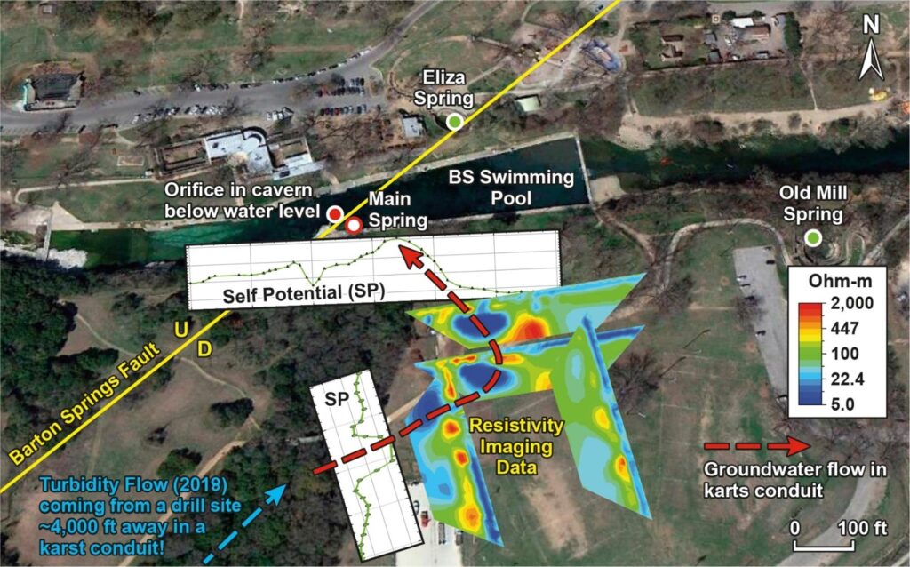
Figure 5. Correlation of geophysical anomalies with the orientation of the turbidity flow projected from the drilling data. High SP and the low resistivity values (dark blue colors) indicate the karstic anomalies (conduit, water-filled cave). The groundwater flow in the conduit, shown with the dashed-red color, takes a bend to the north toward the swimming pool. Note that the turbidity flow coming from the drill site flows parallel to the direction of the Barton Springs fault, crosses the blue resistivity anomalies (conduits) and discharges into the pool. The Old Mill Spring located further to the east was not affected by the turbidity flow (except few trickles of the plume) as the geophysical data predicted.
As seen in Figure 5, the groundwater flow direction from the drill site is projected into the geophysical study area. Naturally, we extend this flow direction into the Barton Springs swimming pool using the geophysical anomalies. As a result, the ground water flow takes a bend to the north where the south gate of the pool (beneath the gate!) is located, and discharges itself at the Main Barton Spring where it intersects with the Barton Springs Fault. Some of the groundwater discharge also occurs via the orifice in the cavern which is located below the pool water to the north of the pool (Figure 1b). This observation suggests that the fault is not a barrier to the groundwater flow in this part of the Barton Springs Segment of the Edwards Aquifer.
Conclusions
Integration of the sediment plume with the geophysical studies have helped increase the understanding of groundwater flow in the vicinity of the Barton Springs Swimming Pool. Surface geophysical methods have successfully located karstic features (caves, faults, conduits) in the pool area, and helped elaborate the groundwater flow direction into the pool area. The groundwater flow direction of the sediment plume aligns well with the locations of karstic anomalies and geologic structures delineated by the geophysical methods. One of the keys to this success has been the applications of (two or more) geophysical methods and working with the geologists of the CoA and BSEACD. It appears that primary geophysical methods for locating karstic features in this part of the Edwards Aquifer are the combination of resistivity imaging and the self-potential methods.
Acknowledgment
I greatly appreciate the critical review by Brian Hunt. I also thank Nico Hauwert for his help and continuing support for this study.
References
Barton Springs/Edwards Aquifer Conservation District (BSEACD), 2019, Paramount Avenue Geothermal Heating/Cooling System Installation and Associated Turbidity Plumes at Barton Springs, Draft internal report, February 15, 2019. 22 p. + appendices
Hunt, B.B., Smith, B.A., and Hauwert, N.M., 2019, Barton Springs segment of the Edwards (Balcones Fault Zone) Aquifer, central Texas, in Sharp, J.M., Jr., Green, R.T., and Schindel, G.M., eds., The Edwards Aquifer: The Past, Present, and Future of a Vital Water Resource: Geological Society of America Memoir 215, p. 75-100, https://pubs.geoscienceworld.org/books/book/2156/The-Edwards-Aquifer-The-Past-Present-and-Future-of
Saribudak, M., Hauwert, N.W., and Hawkins, A., 2013, Geophysical signatures of Barton Springs (Parthenia, Zenobia and Eliza) of the Edwards Aquifer, Austin, Texas, 12th Sinkhole Conference 12 proceedings, Carbonite and Evaporites, Springer.
Saribudak, M and Hauwert, N.W., 2017, Integrated geophysical investigations of Main Barton Springs, Austin, Texas, USA, Journal of Applied Geophysics 138 (2017) 114–126.
Sydow L, Johns DA, Zappitello SJ, Maurer T. 2020. Environmental Forensic Investigation of Mystery Sediment Plumes at Barton Springs, Texas. Proceedings of the 16th Conference on Sinkholes and the Engineering and Environmental Impacts of Karst (The Sinkhole Conference); pp 236-245.
Author Bio

Mustafa Saribudak, Ph.D., P.G.
Mustafa Saribudak is the principal of Environmental Geophysics Associates (EGA). He holds B.Sc. and M.Sc. (1975) in geology from the University of Istanbul and a Ph.D. (1987) from the Istanbul Technical University in Turkey. He came to the University of Houston in 1990 as a visiting geoscientist. He started working for Tierra Environmental in the Woodlands between 1991 and 1993, where he pioneered the application of geophysical methods to environmental problems. He founded EGA in 1994 to provide near-surface geophysical services for engineering, environmental, and oil and gas industries, and real estate developers. Since than he has worked on more than 400 projects.
His research interests have been the growth faulting in the Houston area, major faults of the karstic Edwards Aquifer in central Texas (for example: Mt. Bonnell, Barton Springs and Haby faults); location of karstic features (caves, sinkholes, voids) across the Edwards Aquifer; location of abandoned oil and gas wells and water wells; application of geophysical methods to volcanoes, and application of drone technology to near-surface geology and man-made targets.
