
By Julie Johnston
Published: 07/0/2021
Product Information
Subsurface utility engineers and geophysical service providers need the ability to detect, locate, and characterize subsurface utilities but face numerous challenges in doing so. Underground utilities can be made from many different types of materials and can be located at random depths in soil conditions, ranging from silty clay to sandy loam. Because of this constantly changing pattern of interference, it may take several different technologies to locate and identify unknown utilities.
The best overall practice is to employ multiple types of geophysical technologies, deployed in multiple channel modes when possible. Using digital geophysical mapping in conjunction with common pipe and cable locating tools enhances utility detection and data interpretation. This combined approach produces more complete mapping and supports a more targeted and less expensive test hole program. Limitations in the technologies indicate that careful considerations need to be taken regarding soil type, the terrain, and other geophysical attributes to determine which technologies of a multi-sensor system will be most effective for each applicant’s implementation.
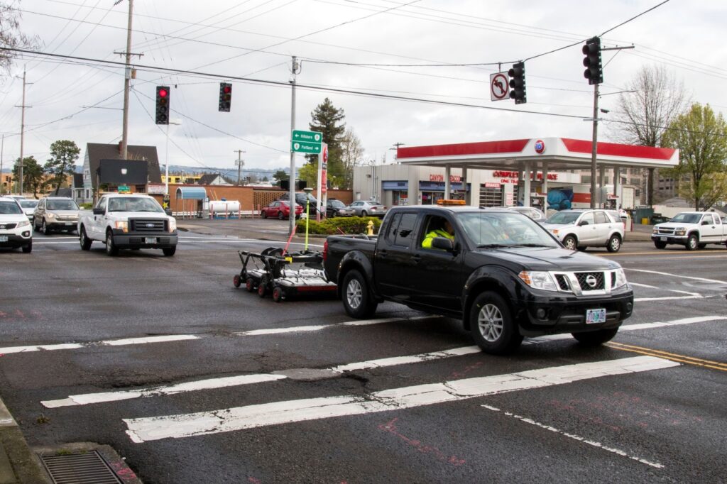
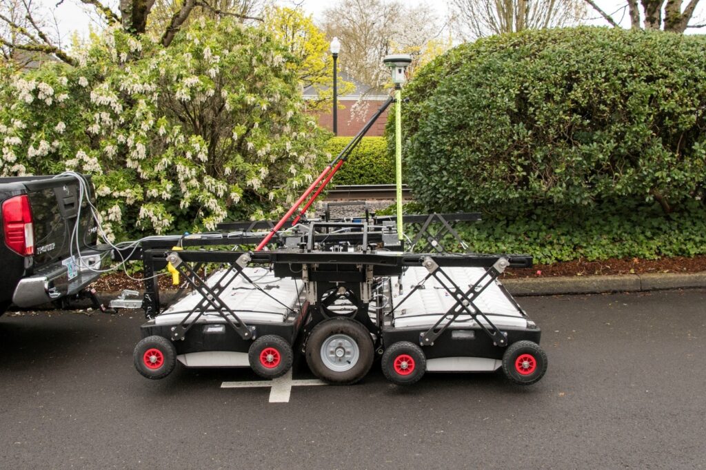
As part of Utility Locating Technologies (R01B), the second Strategic Highway Research Program (SHRP2) identified two advanced utility identification technologies to help transportation agencies obtain more detailed information about subsurface conditions, position and depth of the target utilities. The first is Multi-Channel Ground Penetrating Radar (MCGPR), which consists of deploying a commercially available multiple antenna and/or multiple frequency radar system capable of illuminating targets (i.e., utilities) due to the increased system width, antenna array and frequency range. Because the MCGPR data are synchronized with very accurate GPS, these advanced systems produce results in three-dimensional (3D) volume images of the area(s) investigated. MCGPR results provide accurate positioning of the utilities, as well as a reliable depth to the utility with the goal to achieve Quality Level-B utility locates. Since it is well documented that the GPR technology does not work well in clay-rich soils, another technology was identified by the research to be applicable for SHRP2 implementation. The second technology is Time Domain Electromagnetic Induction (TDEMI), which involves deploying an array of electromagnetic coils which are highly sensitive metal (ferrous or nonferrous metals) detectors that provide digital plan-view mapping of metallic utilities. TDEMI is unaffected by clay-rich soils; however, it cannot detect non-metallic utilities without a tracer wire (e.g., PVC or HDPE). Similar to MCGPR, TEDMI systems are commercially available and can be used in narrow or lane-with mode configurations for flexibility to survey roadways or less-accessible right-of-way areas. TDEMI results are presented in 2D plan view maps, and do not provide insights to the depth of buried utilities. These two technologies were deployed on selected state agency projects as part of the FHWA/AASHTO Implementation Assistance Program.
ODOT Project Implementation
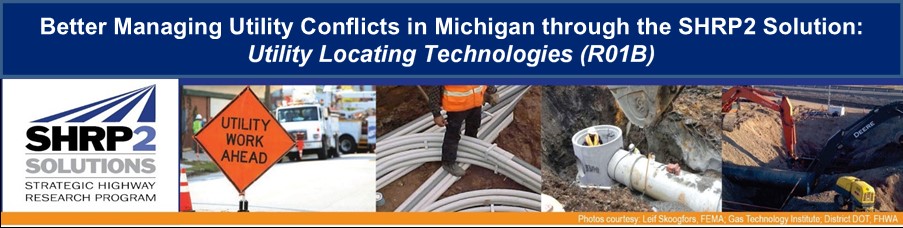
The Oregon Department of Transportation (ODOT) was awarded a SHRP2 R01B – Utility Investigation Technologies grant as part of the SHRP2 Round 7 application process. ODOT used R01B funds to establish a subsurface utility engineering (SUE) program and conduct an investigation using MCGPR and TDEMI technologies on an ODOT project in Beaverton, Oregon. The project is the OR-8 (Canyon Road): SW Short Street to SW Hocken Ave project (OR-8 Project), which is a pedestrian safety, signal upgrade, and streetscape improvement project.
The goals of the ODOT R01B project were to:
- Expand the ODOT SUE team and its strategy for statewide use.
- Receive classroom training and hands-on instrumentation demonstrations for the SHRP2 MCGPR and TDEMI technologies.
- Evaluate ODOT’s utility identification process to determine how to integrate with SUE.
- Create a SUE Project Evaluation form (to answer the question “Do I need SUE for this project?”).
- Create standard contract language to aide in obtaining future SUE investigation services.
- Evaluate the advanced utility locate technologies: MCGPR & TDEMI.
- Document the SUE field data collection process for internal ODOT training and promote its value statewide.
- Receive additional GPR instrumentation and data processing training for ODOT personnel to become involved in geophysical investigations using GPR for traditional SUE projects.
- Expand the use of SUE statewide.
Project Summary
ODOT’s SUE team, established during the R01B SHRP2 grant application process, began meeting regularly to address SUE issues statewide. Once the R01B grant was awarded and the grant program was launched, the SUE team focused on selecting a suitable ODOT project, and started developing the contract language, specifications and requirements to procure a consultant for conducting the R01B advanced locating technologies for the grant.
The OR-8 Project was selected, and the SUE team began working with the project team to integrate the R01B and SUE requirements into the project work plan. The process to contract with a consultant for SUE services took more than a year to complete. During that year, the contract language for SUE services was developed, the utility process was defined and parameters for SUE application were determined; and finally, an evaluation form was created for determining if SUE is needed on a project. Once the procurement process was complete, the vendor was awarded the contract for R01B and the SUE work for the OR-8 Project.
Work began on the field data collection portion of the project using a survey crew, a utility designating crew, a geophysics team (MCGPR and TDEMI), and a vacuum excavation truck to perform the work. They used an IDS Stream EM system for the MCGPR data collection. A Geonics EM-61 MK2A was selected for the TDEMI portion of the work. The field portion of the work was completed quickly in just under 300-person hours of time spent in the field. Upon completion of the field work, the vendor analyzed the data and created 3D models of the subsurface utilities. This process took more than 6 months and about 800-person hours to deliver the final maps. These maps provided a much better picture of the subsurface utilities than a typical one-call locate request would have generated. Multiple unknown and unmarked features were found that will greatly reduce potentials conflicts and avoid construction strikes and delays.
The results of the MCGPR and TDEMI evaluation showed that MCGPR was much better suited for conducting whole site surveys and that TDEMI is better suited for small areas and specific applications. THE MCGPR was also successful in soils that were marked as Moderate to Low on the NRCS GPR Suitability Map for Oregon. Videos of both systems in use were developed for future training and education of others at ODOT; these videos are available on the AASHTO SHRP2 website http://shrp2.transportation.org/Pages/UtilityRelatedProducts.aspx
The ODOT project successfully collected data for the OR-8 Project, created documents and language for future SUE work, provided a wealth of information about SUE and educated the entire team on advanced geophysics.
The greatest challenge faced by the SUE team during the project was the internal process required to procure SUE services from a qualified consultant, capable of deploying the R01B utility locating technologies. The existing A&E contracting process does not include SUE and/or advanced geophysics as an allowed or approved service. Without being able to use the existing A&E contracting method, ODOT was forced to create a unique contract, which required that each part had to be evaluated by multiple parties including the State Department of Justice. The process took 9 months to generate a Request for Proposals (RFP) plus 4 additional months to secure a signed and executed contract with the approved vendor.
Another challenge was the timeline for delivery of the resultant maps and project data from the consultant. The MCGPR and TDEMI data required more processing time then the consultant had anticipated pushing the deliverables back a few months from their initial estimate.
Lessons Learned
- The overall knowledge of what constitutes SUE and how geophysics fits into ODOT projects significantly increased over a period of 6 months.
- MCGPR and TDEMI is complicated. While the equipment may be easy to use and collects data quickly and safely, it also requires considerable time and skill to process and evaluate.
- There is a need for specific language and terms in RFPs to ensure that respondents include SUE-specific qualifications in their responses; DOTs need to differentiate SUE from utility coordination, as well as standard SUE procedures from advanced utility location technologies including MCGPR and TDEMI.
- Sufficient historical data is necessary to use as a guide or method by which to estimate SUE costs.
- Establishing an on-call/pre-approved list for geophysical service providers will speed the process to avoid a year long wait to hire a consultant.
- DOTs should evaluate whether 3D deliverables versus standard 2D deliverables are needed, because the time and cost between them is substantial.
Future Plans
The ODOT SUE team has already selected the next project that will use a SUE consultant and the documents created during the R01B project are being used to expedite the review and procurement process. The scale of this new project should create a whole new round of lessons learned and potentially be the project that tips ODOT to evaluate the need for SUE on every project. The ODOT is moving forward with creating in-house capacity to conduct basic GPR investigations. There have been equipment demonstrations, advanced GPR training though Olson Engineering (the SHRP2 R01B Subject Matter Expert), and rented equipment used for some small pilot projects. The immediate goal is to create a core group of GPR users that can conduct basics GPR surveys, evaluate projects for GPR usage, review consultant GPR/SUE work, and advocate for SUE in general. The ODOT hope to purchase its own equipment and begin testing it statewide in the next 3 to 4 months.
Author’s Bio

Julie Johnston
Julie Johnston is the Utility, Railroad and Value Engineering Program Manager for the Federal Highway Administration. She joined FHWA in 2011 as an Area Engineer in the Michigan Division Office and while there worked on program’s such as Emergency Relief, Utilities, Value Engineering, Freeway Lighting, Roadside Development and Rest Areas. Julie has over 20 years of experience in transportation working not only at FHWA, but at the Michigan Department of Transportation and in the private consulting industry performing road and underground utility design and construction oversight.
