
By Hany M. Hassan1,2 and Mohamed ElGabry1
1National Research Institute of Astronomy and Geophysics, 11421 Helwan, Cairo, Egypt
2National Institute of Oceanography and Applied Geophysics- OGS, Udine, Italy
Abstract
Ambient vibrations analysis, also known as ambient noise testing, has become an increasingly popular tool for earthquake engineering applications in recent years. This technique involves measuring the natural vibrations of a structure in response to ambient environmental forces, such as wind or traffic, using sensors placed on or around the structure. Various ambient vibration measurements for different cultural heritage minarets within the Citadel of Cairo are deployed to extract the dynamic characteristics of the minarets of interest. The dynamic characteristics can be used to calibrate the detailed numerical models or to be archived in a database, which can be used to detect the variation in the mechanical properties of different parts of the minarets due to different factors such as material deterioration, local site condition, or retrofitting. Dynamic testing based on ambient vibration measurements at different heights in five historical minarets of the Citadel was accomplished. Also, seismic input at the site of the Citadel was provided for providing the end used with a complete picture about seismic hazard situation based on the current understanding. We call for a detailed site response analysis and site-specific seismic hazard analysis for the Citadel which can lead to informed decision regarding future restoration plans. As future development we also recommend to continue recording ambient vibration inside the historical monuments in order to have enough databases that can increase the knowledge about the dynamical behavior of these valuable structures.
Introduction
The Citadel of the Salah al-Din (Qal’at al-Jabal), which is located in Cairo (Figure 1), is an architectural complex with a long history of building and rebuilding. Situated on a bump that was artificially cut out of the Mokatam Hills, the Citadel originally faced, and overlooked, the city of Cairo to the west and northwest, and the city of Misr al-Fustat in the south; its northern and eastern sides were bordered by either rocky hills or the desert. It is considered one of the most luxurious military castles built in the Middle Ages (Rabbat 1995).
The Citadel was founded by Salah al-Din al-Ayyubi in 1176, it was, for almost seven centuries (1206-1874), the place of government for the Ayyubids, Mamluks, Ottomans, and the Muhammad Ali dynasty. It was, during this seven centuries, the stage upon which the history of Egypt was played. It witnessed various harmful historical events during the Ayyubid and Mamluk eras and the French occupation of Egypt in 1798, until Muhammad Ali Pasha reigned in Egypt where he restored its prosperity and greatness (Behrens-Abouseif 2010; IshakBakhoum 2016). The continuous building and rebuilding process may be viewed both as a reflection and as a formal expression of changing political and cultural conditions. However, the Citadel has inherited over time many unique historical monuments that make it a favorite destination for tourists.
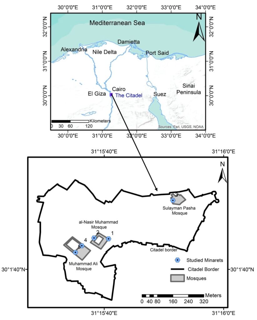
Figure 1: The location of the citadel in a regional map (Top panel); a plan of the Citadel with the studied minarets marked by light blue hexagonal with black dot in the center (Bottom panel).
Today, the Citadel contains three mosques that are from the oldest to the youngest al-Nasir Muhammad Mosque and School, Sulayman Pasha Al-Khadim Mosque (Sariyat Al-Jabal), and Muhammad Ali Mosque. These mosques were built at different periods that reflect the historical evolution of the Citadel i.e. Early BahriMamluk Period (1250-1341) (al-Nasir Muhammad), the Ottoman Period (1517-1798) (Sulayman Pasha) and the Muhammad Ali dynasty (Mosque of Muhammad Ali) (Figure 1).
Minarets that appear in images of the late 19th century in quite a ruined state (Figure 2) were endangered not only as a result of neglect and lack of maintenance, but also due to past earthquake impacts. The earthquake that occurred on 25 Šaʿbān 1263/August 7, 1847 is better known as it was noted by Edward William Lane (1801–1876) (Ambraseys et al., 2005). The earthquake affected al-Azbakiyya, where three minarets lost their tops and the falling debris of one killed a woman. Damage to the northern minaret of the mosque of al-Muʾayyad (no longer extant and not to be confused with one of its twin-minarets on top of BābZuwayla) is noted in detail as is the damage suffered by the southern minaret of the twin-minarets of the ḫānqāh of Faraǧibn Barqūq in the Northern Cemetery.
In this work we apply short-term structural health monitoring and the dynamic testing for the minarets of the citadel based upon temporary campaign. Regarding the dynamic tests the most performed ones are the Ambient Vibration Tests (AVTs). The easy deployment of the experimental setup and the avoiding of energy consumption to create the artificial input make these tests very appealing. In general, the final aim of the dynamic tests is to enhance numerical model useful to perform accurate analysis of structural assessment. The minaret of Al-’Azab Mosque in not tackled herein, because of the limited access.
Why the current research work focuses on minarets? While minarets dominates the skyline of Cairo and its famous citadel and attracted the attention of many travelers, artists and photographers, they were also an important element in the urban fabric of the city and also of the mosque and were used by the muʾaḏḏin for the call to prayer until electricity and the amplifier was connected to mosques around the middle of the 20th century. From a structural and architecture perspectives, minarets are not only a challenge to construct, but their restoration must have been a costly and difficult task, especially as many of them suffered after a number of earthquakes that will be discussed below (Figure 2) (Behrens-Abouseif, 2010; Ishak Bakhoum 2016). The shape and decoration of the minaret not only represent an art-historical phase, but also a political shift; Behrens-Abouseif when discussing the construction rather than the restoration of Ottoman style minarets in Cairo as indicated by Behrens-Abouseif, (2010) “There is no architectural development in the history of Cairo that can be so closely linked to political change as the almost universal replacement of the Mamluk multiple-tiered minaret with the pencil-shaped shaft following the Ottoman conquest”. The minarets is important part of our heritages, which is a symbol of identity and an essential element of our memory, holds our shared principles and values and can be transferred to future generations.
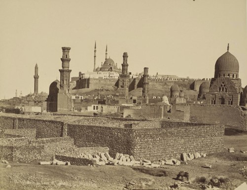
Figure 2: A photo of the Citadel and Mamluk Tombs, ca. 1865. Photographer: J. Pascal Sébah.
Minarets of al-Nasir Muhammad Mosque and School (Early Bahri Mamluk Period, 1335)
The Mosque of Sultan Al-Nasir Muhammad ibn Qalawun is located in the southern residential part of the citadel. The Mosque of al-Nasir Muhammad is the only Bahri structure still standing in its entirety. It is one of the most serene and dignified mosques in Cairo with its simple almost square plan, it’s tastefully reused Pharaonic and Ptolemaic columns. The two minarets, one on the southeastern corner and one above the main door, are situated so as to face the two audiences to whom the call to prayer (adhan) was directed. The minarets are architecturally different from each other, and both are quite unusual in shape and surface articulation. The upper parts of both their shafts and their finials were covered with green enameled tiles, with bands of white Qur’anic inscription on a blue background surrounding the bases of the finials. There is nothing else quite like them in Cairo, and they are believed to be the work of a Tabrizi master builder who was active in Cairo around the year 1335, when al-Nasir renovated the mosque for the second time. The minaret located to the right of the main entrance (northwest) has height of about 39.4 m, while the other minaret is located in the southeast corner of the mosque and has 36.7 m height. Both are composed of two balconies, but different architecture, ornamentation, and geometry as shown in Figures 3 and 6.

Figure3 . General view of the Mosque of al-Nasir Muhammad.
Minaret of Sulayman Pasha Al-Khadim Mosque (Sariyat Al-Jabal, the Ottoman Period, 1528)
The Mosque of Sulayman Pasha was the first, and to a certain degree stylistically the purest, Ottoman mosque in Cairo. It was founded by Sulayman Pasha al-Khadim, the governor of Ottoman Egypt, in 1528. Built in the northern enclosure for the Janissaries, this mosque occupied the site of an older mosque, that of Sidi Sariyya built by a Fatimid governor of Alexandria, Abu-Mansur Qasta in the twelfth century. The plan of the Mosque of Sulayman Pasha is of the Ottoman central domed type. The dome, which covers the prayer hall, and the semi-domes surrounding it are all covered on the exterior with green tiles. The fluted, cylindrical minaret is among the earliest of this Ottoman type in Cairo. The minaret is located between the Haram and the hall of Prayer. It is built in the Ottoman style (pencil) and has 37.1 m height (Figures 4 and 7).
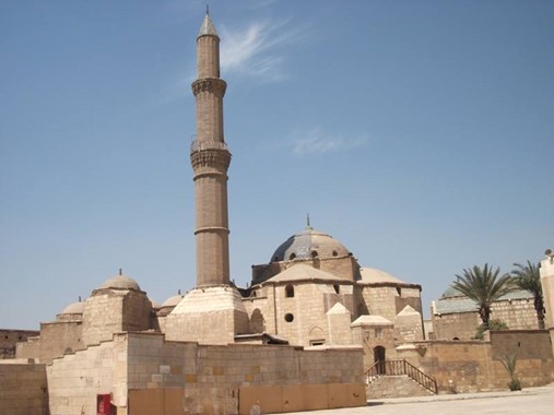
Figure 4: Recent photo of the Mosque of Sulayman Pasha.
Minarets of Muhammad Ali Mosque
The Mosque of Muhammad ‘Ali stands at the northwestern corner of the southern enclosure, where the Striped Palace of al-Nasir Muhammad once stood, and is visible from almost every location in Cairo. It is the best known structure at the Citadel today, and in the colloquial language its name was given to the whole Citadel. Mosque design represents a mixture of local and Turkish architecture, in particular the Sultan Ahmed Mosque in Astana (Hagia Sophia). The mosque’s two slender pencil minarets soar to a height of about 84 meters and each minaret 256 degrees ladder to the end of the second cycle and are identical in terms of architectural and dimensions (Figures 5, 8). The central dome, with its four supporting semi-domes all covered with lead sheets, is 52 meters high.

Figure 5: Recent photo of the Mosque of Muhammad Ali.
Ambient Vibrations Data Acquisition and Analysis
Ambient vibrations analysis, also known as ambient noise testing, has become an increasingly popular tool for earthquake engineering applications in recent years. This technique involves measuring the natural vibrations of a structure in response to ambient environmental forces, such as wind or traffic, using sensors placed within the structure. In the context of historical heritage structures, ambient vibrations analysis has proven to be an effective assessment tool for a number of reasons. Firstly, it allows engineers to assess the structural integrity and stiffness of the building without the need for invasive testing, which could potentially damage or alter the structure. Secondly, it can provide valuable information on the dynamic characteristics of the building, such as its natural frequencies and mode shapes, which can be used to develop accurate structural models for further analysis. Furthermore, ambient vibrations analysis can be particularly useful for development of empirical relationships historical heritage structures (e.g., Gueguen et al., 2014), which may have unique or complex geometries that make traditional testing methods difficult or impossible. In addition, ambient vibrations analysis can be performed over extended periods of time, allowing engineers to monitor the structural health of the building and detect any changes or degradation over time.
In this study, ambient noise measurements were performed on 5th and 6th of November, 2019 using 4 seismic stations (i.e. accelerometers). During the first day of field measurement, the two minarets of al-Nasir Mohammed Mosque were instrumented with 4 stations along each as illustrated in Figure 6. In the second day, the minarets of Sulayman Pasha and Muhammad Ali were instrumented as shown in Figures 7 and 8. Regarding, minarets of Muhammad Ali Mosque, four instruments were deployed one at the floor, the second at the transition zone from square geometry near mosque roof, the third at the first balcony and the fourth at the top balcony close (Figure 8). The sensors were balanced and oriented to the north direction. The stations were equipped with Güralp broadband seismometers (6DT). The sampling rate was set to 100 samples per second and again 10 is used for the pre-amplifier. GPS antennas guaranteed the time synchronizations among the instruments. The ambient vibration recording lasted for 60 minutes, with a recording sample frequency of 50Hz. Post-processing of the acceleration measurements with baseline correction and high-pass filter hasbeen considered. A fourth-order Butterworth band-pass filter was applied 0.1-50 Hz. Geopsy software package was used for analysis of collected ambient noise data from each sensor which is widely used by earthquake engineers, seismologists, and geophysicists. The software includes a range of tools for processing and analyzing ambient noise data, including cross-correlation, spectral analysis, and Horizontal over vertical ration analysis (H/V).
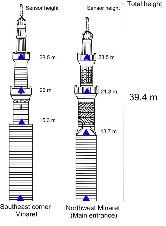
Figure 6: al-Nader Muhammad’s minarets geometry and instrumentation (blue triangle) locations (all dimensions are in meter). Southeast minaret marked as no. 1 in Figure 1, while northwest one marked as no. 2.
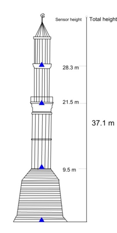
Figure 7: Sulayman Pasha’s minaret geometry and instrumentation (blue triangle) locations (all dimensions are in meter). Marked as minaret no. 3 in Figure 1.
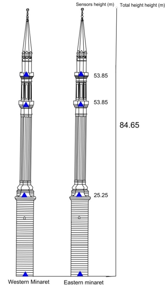
Figure 8: Muhammad Ali’s minaret geometry and instrumentation (blue triangle) locations (all dimensions are in meter). Southeast minaret marked as no. 4 in Figure 1, while northwest one marked as no. 5.
Results and Discussion
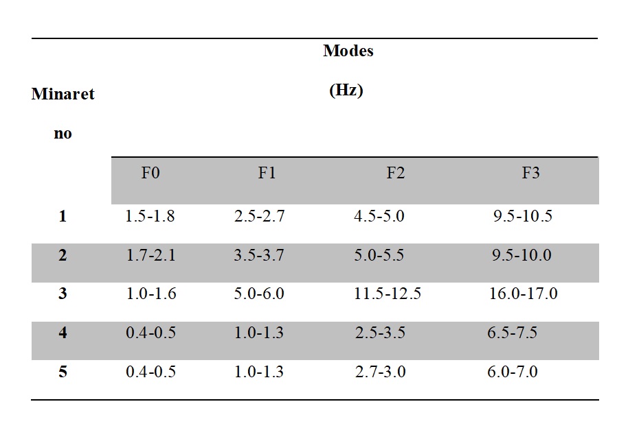
The filtered recorded noise time history at the top balcony of one of the minarets of al-Nasir Muhammad mosque is illustrated in Figure 6. Figure 10 illustrates the power spectra of the time series in the three orthogonal directions (East-West component-left panel and North-South component-right panel) at the base, transition part, then first and second balconies measurement points, from base to top, respectively. The results shown in Figure 10 and summarized in Table 1 indicate that the observed natural frequency (F0) and higher modes of the Southeast minaret shown in Figure 6. Post-processing the different minaret measurement points confirms that the natural frequency of the minaret is approximately 1.5-1.8 Hz (Figure 10 and Table 1). The power spectra of the ambient noise record at the Northwest minaret of the mosque is shown in Figure 11, they clearly show a natural frequency of 1.7-2.1 Hz and listed in Table 1 with higher modes. The lower estimated F0 of the Southeast minaret relative to the Northwest maybe due to the difference in height and geometry between the two minarets.
The power spectral density for the two horizontal components E (left) and N (right) left of ambient vibration measurements in the minaret of Sulayman Pasha Mosque is presented in Figure 12. The estimated natural frequency is in a range of 1.0-1.6 Hz and shown in Table 1 with higher modes.
The twin minarets of the Mosque of Muhammad Ali show identical natural frequency, also higher modes they are similar. Power spectral density for the two horizontal components E (left) and N (right) left of ambient vibration measurements in the Southeast and Northwest minarets of Muhammad Ali mosque are shown in Figures 13, 14. The results are shown from the top (upper) to the base (bottom) to the base i.e. top balcony, second balcony, first balcony and the base (Figure 8). The power spectral density manifest a fundamental frequency of 0.4-0.5 Hz for the twin minarets (as shown in Figures 13&14 and Table 1). As they are identical interms of geometry, shape, tall and architecture style they also show quit identical F0 and higher modes (Table.1). The power spectral density computed for the top balcony of the northwest minaret (no. 5) shows relatively high power (amplitude) at high frequency range 20-40 Hz, the observed behavior could be due to the presence of electric cable used for light and sound magnification purpose. This interpretation is based on visual inspection after this behavior was recognized.
Ambient vibration tests results can be used by end users and earthquake engineers to validate and eventually update numerical models (Caprili et al., 2011; Oliveira et al., 2012; Hassan et al., 2023) and/or be used directly to compute the structural dynamic response under seismic action (Michel et al., 2012; Perrault et al., 2013).
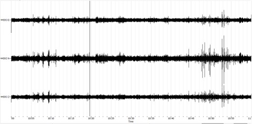
Figure 9: Ambient noise time series in three components (E, N, and Z) at top balcony of the minaret of al-Nasir Muhammad mosque.
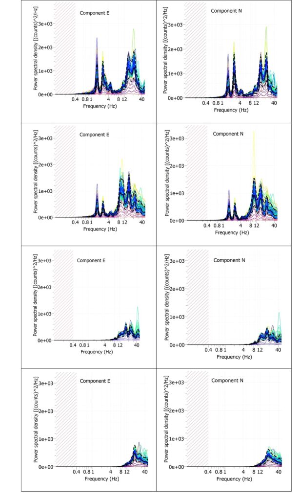
Figure 10: Power spectral density for the two horizontal components E (left) and N (right) left of ambient vibrationrecords in the South-east minaret of the Mosque of al-Nasir Muhammad. The results are shown from the top (upper) to the base (bottom) to the base i.e. top balcony, second balcony, first balcony and the base (Figure 6). The figures show a fundamental frequency of about 1.5-1.8 Hz.
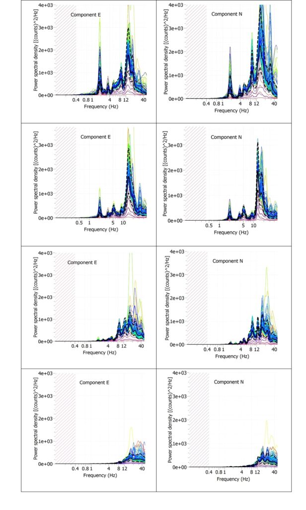
Figure 11: Power spectral density for the two horizontal components E (left) and N (right) left of ambient vibrationrecords in the Northwest minaret of the Mosque of al-Nasir Muhammad. The results are shown from the top (upper) to the base (bottom) to the base i.e. top balcony, second balcony, first balcony and the base (Figure 6). The figures show a fundamental frequency of about 1.7-2.1 Hz.
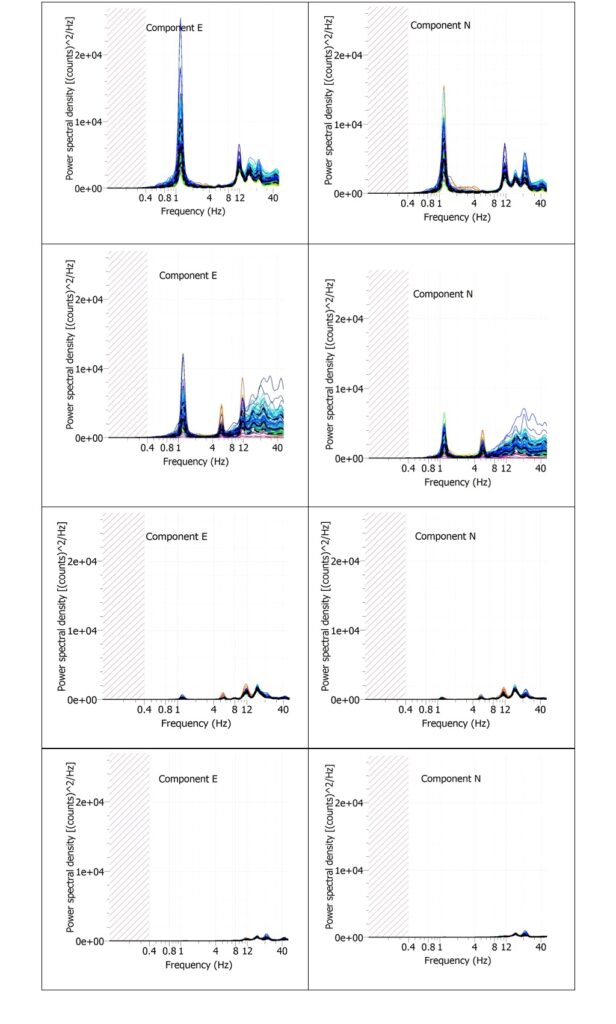
Figure 12: Power spectral density for the two horizontal components E (left) and N (right) left of ambient vibration records in the minaret of Sulayman Pasha Mosque. The results are shown from the top (upper) to the base (bottom) to the base i.e. top balcony, second balcony, first balcony and the base (Figure 7). The figures show a fundamental frequency of about 1.0-1.6 Hz.
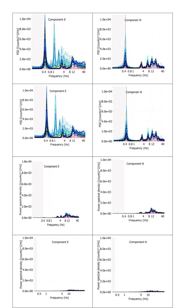
Figure 13: Power spectral density for the two horizontal components E (left) and N (right) left of ambient vibration records in the Southeast minaret of Muhammad Ali’sMosque. The results are shown from the top (upper) to the base (bottom) to the base i.e. top balcony, second balcony, first balcony and the base (Figure 8). The figures show a fundamental frequency of 0.4-0.5 Hz.
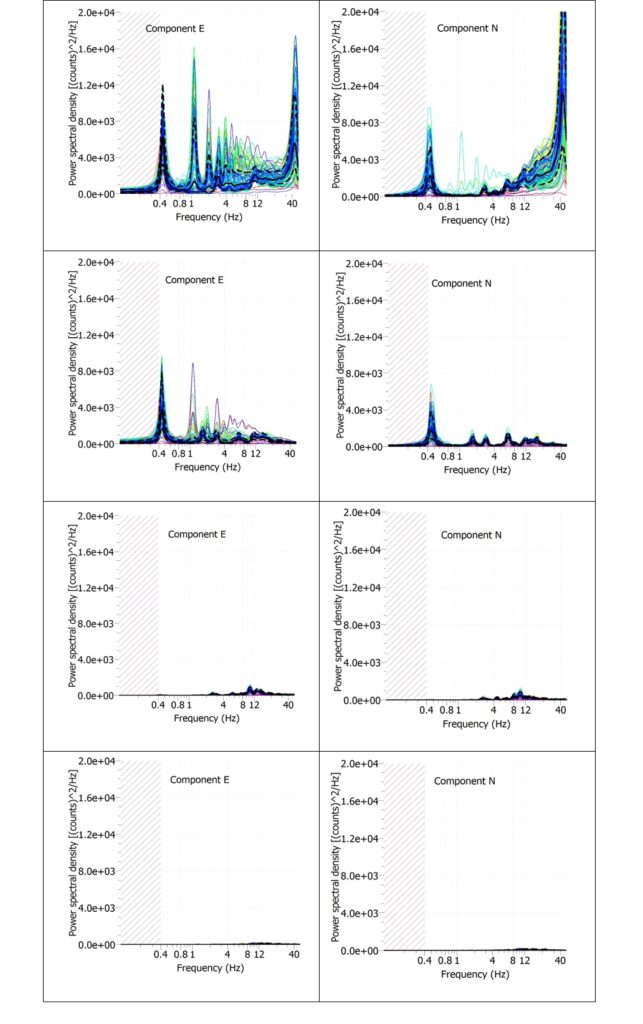
Figure 14: Power spectral density for the two horizontal components E (left) and N (right) left of ambient vibration records in the North-western minaret of Muhammad Ali’s Mosque. The results are shown from the top (upper) to the base (bottom) to the base i.e. top balcony, second balcony, first balcony and the base (Figure 8). The figures show a fundamental frequency of about 0.4-0.5 Hz.
Table 1. Modal analysis results of the measured ambient vibration.
Conclusions
Dynamic testing based on ambient vibration measurements at different heights in five historical minarets of the Citadel was accomplished. This is step can be viewed as an application of proactive geosciences. The data were archived then analyzed in order to extract useful information that can be used to justify the engineering model for the linear and non-linear dynamical analysis for these structures. The collected data and results can be archived to form a database that can be augmented with many other examples in the future for better understanding of the dynamical behavior of the minarets and can help in their protection, preservation and restorations. The data can be used in the future to recognize or early diagnose of any process of deterioration and deficiency that may happen in the future due to long or short term natural or artificial action. We have focused primary on the minarets because they represent an important structural element of the citadel urban fabric. Also, they have been known to have weak performance during the seismic action.
Minarets that appear in images of the late 19th century in quite a ruined state (Figure 2) were endangered not only as a result of neglect and lack of maintenance, but also due to a number of recorded earthquakes. The seismic input at the site of the citadel was computed using the Neo-Deterministic Seismic Hazard Analysis-NDSHA Approach (Panza et al., 2001; Panza et al., 2012; Kossobokov & Panza, 2022; Panza & Bela, 2020; Panza & Bela, 2021) based on the national hazard computation have been accomplished for Egypt in Hassan et al, (2017, 2020) and ElGabry and Hassan et al., (2021) at bedrock level that take into account all available source information (Gorshkov et al., 2019&2022), average structural model for the path between the source and receiver. The mean and maximum ground motion percentiles (Shaded gray area) of the computed response spectra are shown in Figure 15. Also, the natural frequencies for the minarets were projected at the spectrum. The natural frequencies of the minarets incidentally occur in a range of period 0.5-2.5 second. Figure 15 indicate that the fundamental periods of the studied fortunately, avoid the range of period with high spectral acceleration (550 cm/s2) and are placed at range of relatively less dangerous (450 cm/s2).
The historical evolution of the citadel indicates a continuous building and rebuilding process that may be viewed as a reflection and as a formal expression of changing political and cultural conditions. Due to that the ground level of the citadel was rising as a result of the process of erecting new buildings on top of older ones (Rabbat 1995) which urge detailed site response analysis and site-specific seismic hazard analysis for the Citadel which can lead to informed decision regarding future restoration plans. Therefore, detailed site response analysis is indispensable in order to properly estimate the potential hazard. As future development we also recommend to continue recording ambient vibration inside the historical monuments in order to have enough databases that can increase the knowledge about the dynamical behavior of these valuable structures.
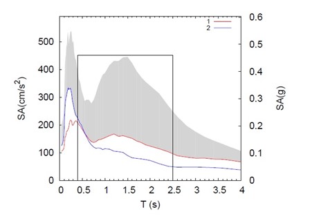
Figure 15: Computed response spectra at bedrock at the site of the citadel. The window of the fundamental periods of the studied minarets is plotted as black rectangle. Shaded gray area represents the mean and the maximum percentiles. Blue and Red Line are the mean ground motion of two earthquake scenarios impacting the site based on the national scale computation of Hassan et al., 2017.
References
Ambraseys, N. N., Melville, C. P., and Adams, R. D., 2005, The seismicity of Egypt, Arabia and the Red Sea: a historical review. Cambridge university press.
Behrens-Abouseif, D., 2010, The minarets of Cairo: Islamic architecture from the Arab conquest to the end of the Ottoman Empire. IB Tauris.
Beskhyroun, S., Oshima, T., Mikami, S., Tsubota, Y., and Takeda, T., 2006, Damage identification of steel structures based on changes in the curvature of power spectral density. In 2nd International conference on structural health monitoring of intelligent infrastructure.TAYLOR & FRANCIS LTD.
Caprili, S., Nardini, L., and Salvatore, W., 2012, Evaluation of seismic vulnerability of a complex RC existing building by linear and nonlinear modeling approaches. Bulletin of Earthquake Engineering, 10, p. 913-954.
ElGabry, M., and Hassan, H. M., 2021, Updated seismic input for next generation of the Egyptian building code. In Sustainable Issues in Infrastructure Engineering: The official 2020 publication of the Soil-Structure Interaction Group in Egypt (SSIGE), Springer International Publishing, p. 55-79.
Gorshkov, A., Hassan, H. M., Mandal, P., and Novikova, O., 2022, Identifying potential earthquake sources in continental environments. Surveys in Geophysics, 43(2), p. 529-559.
Gorshkov, A. I., Hassan, H. M., &Novikova, O. V., 2019, Seismogenic Nodes (M≥ 5.0) in Northeast Egypt and Implications for Seismic Hazard Assessment. Pure and Applied Geophysics, 176(2), p. 593-610.
Gattulli, V., Lepidi, M., & Potenza, F., 2016, Dynamic testing and health monitoring of historic and modern civil structures in Italy. Structural Monitoring and Maintenance, 3(1), p. 71-90.
Gattulli, V., Antonacci, E. and Vestroni, F., 2013, “Field observations and failure analysis of the Basilica S. Maria di Collemaggio after the 2009 L’Aquila earthquake”, Eng.Fail. Anal., 34, p. 715-734.
Gattulli, V., Potenza F., Graziosi F., Federici F., Colarieti A. and Faccio M., 2014, Design of wireless sensor nodes for structural health monitoring applications, Procedia Eng., 87, p. 1298-1301.
Gueguen, P., Gallipoli, M. R., Navarro, M., Masi, A., Michel, C., Guillier, B., and Spina, D., 2014, August). Testing buildings using ambient vibrations for earthquake engineering: a European review. In Proceedings of the 2nd European conference on earthquake engineering and seismology (2ECEES), Istanbul.
Hassan, H. M., Romanelli, F., Panza, G. F., ElGabry, M. N., and Magrin, A., 2017, Update and sensitivity analysis of the neo-deterministic seismic hazard assessment for Egypt. Engineering geology, 218, p. 77-89.
Hassan, H. M., Fasan, M., Sayed, M. A., Romanelli, F., ElGabry, M. N., Vaccari, F., and Hamed, A., 2020, Site-specific ground motion modeling for a historical Cairo site as a step towards computation of seismic input at cultural heritage sites. Engineering Geology, 268, 105524.
Hassan, H. M., Sayed, M. A., Fasan, M., Romanelli, F., Amadio, C., Hamed, A., and Hamama, I., 2023, Seismic Assessment of a Cultural Heritage Minaret in Cairo. In Sustainable Conservation of UNESCO and Other Heritage Sites Through Proactive Geosciences, Springer International Publishing, p. 541-565.
Ishak Bakhoum, D., 2016, Mamluk Minarets in Modern Egypt: Tracing Restoration Decisions and Interventions. In Annales islamologiques, No. 50, Institut français d’archéologie orientale (IFAO), p. 147-198.
Kossobokov, V., and Panza, G., 2022, Seismic roulette: Hazards and risks. Terra Nova, 34(6), p. 475-494.
Michel, C., Gueguen, P., and Causse, M., 2012, Seismic vulnerability assessment to slight damage based on experimental modal parameters. Earthquake engineering & structural dynamics, 41(1), p. 81-98.
Oliveira, C. S., Çaktı, E., Stengel, D., and Branco, M., 2012, Minaret behavior under earthquake loading: The case of historical Istanbul. Earthquake Engineering & Structural Dynamics, 41(1), p. 19-39.
Panza, G. F., La Mura, C., Peresan, A., Romanelli, F., and Vaccari, F., 2012, Seismic hazard scenarios as preventive tools for a disaster resilient society, Advances in geophysics, Vol. 53, p. 93-165.
Panza, G. F., and Bela, J., 2020, NDSHA: A new paradigm for reliable seismic hazard assessment, Engineering Geology, 275, 105403.
Panza, G. F., and Bela, J., 2021, Reliable seismic hazard assessment: NDSHA. AJNTS, 13.
Panza, G. F., Romanelli, F., and Vaccari, F., 2001, Seismic wave propagation in laterally heterogeneous anelastic media: theory and applications to seismic zonation. In Advances in geophysics, Vol. 43, p. 1-95.
Perrault, M., Gueguen, P., Aldea, A., and Demetriu, S., 2013, Using experimental data to reduce the single-building sigma of fragility curves: case study of the BRD tower in Bucharest, Romania. Earthquake Engineering and Engineering Vibration, 12, p. 643-658.
Rabbat, N. O., 1995, The Citadel of Cairo: A New Interpretation of Royal Mameluk Architecture, Vol. 14, Brill.
Sohn, H., Farrar, C. R., Hemez, F. M., Shunk, D. D., Stinemates, D. W., Nadler, B. R., and Czarnecki, J. J., 2003, A review of structural health monitoring literature: 1996–2001. Los Alamos National Laboratory, USA.
Authors’ Bios

Hany M. Hassan
Dr. Hany M. Hassan is a dedicated researcher with expertise in the fields of earthquake and tsunami studies. He currently works as a Researcher at the National Research Institute of Astronomy and Geophysics (NRIAG) in Egypt since October 2018. In addition to his role at NRIAG, Hany serves as a Junior Associate at the International Centre for Theoretical Physics (ICTP) in Trieste, Italy, from 2022 to 2028. Hany is an active member of the North Africa Group for Earthquakes and Tsunami Studies (NAGET), affiliated with Net40/OEA ICTP. He has been contributing to NAGET since 2013, focusing on various aspects of earthquake and tsunami research in the Mediterranean and Adriatic Seas. With extensive experience in his field, Hany’s expertise encompasses tsunami and earthquake modeling, tsunami risk assessment, earthquake hazard and risk analysis, computation of synthetic seismograms for seismic hazard assessment, earthquake monitoring and seismic networks, and evaluation of seismic vulnerability of buildings, as well as the assessment of site response.
Hany’s passion for understanding and mitigating the effects of earthquakes and tsunamis on coastal regions drives his research and dedication to the field. His work plays a crucial role in enhancing our understanding of these natural hazards and contributes to the development of strategies for better preparedness and resilience.

Mohamed ElGabry
Geophysicist and natural hazards expert, currently a Professor at Egypt’s National Research Institute of Astronomy and Geophysics (NRIAG) and holds the position of Director at the African Disaster Mitigation Research Center (ADMiR). Additionally serve as the Vice President of the African Seismological Commission. Prof. ElGabry’s research focus lies in seismic and tsunami hazard assessment across Africa, and particularly intrigued by the potential of open-source data in Disaster Mitigation. With a strong commitment to enhancing our comprehension of natural hazards and fortifying communities against Natural Hazards.
