Angelo Lampousis, PhD,
City College of New York
Welcome back to our FastTIMES Agricultural geophysics news column. We welcome technical news and accompanying article contributions to this column from the agricultural and soil sensing communities. Please send your contribution to me at alampousis@ccny.cuny.edu
2020 ASA-CSSA-SSSA – Translating Visionary Science to Practice

As noted previously from this column, the American Society of Agronomy, the Crop Science Society of America, and the Soil Science Society of America hosted thousands of scientists, professionals, educators, and students from around the world at this year’s meeting that was offered virtually between November 9th and 13th, 2020. This event was additional proof of how the COVID-19 pandemic has enabled or even forced organizations big and small to transition to the online world at an accelerated pace.
The 2020 ASA-CSSA-SSSA virtual meeting was entitled “Translating Visionary Science to Practice” and according to the organizers provided participants for opportunities to connect worldwide. The virtual meeting will remain available until February 13, 2021 and boasts 2,500 oral and poster presentations, and hundreds of recorded sessions.
Although there are no obvious overlaps between the current special issue on mine site geophysics and agricultural geophysics, the Conference does provide for an opportunity to recognize the efforts of visionaries from around the world working on the reclamation of mined land for agricultural use. This includes both abandoned coal mines and surface mines. United Kingdom coal mines can be reportedly reclaimed for growing herbs and vegetables representing an attractive alternative to vertical greenhouse farming using inexpensive LED lights. Revegetation of open surface mines on the other hand can follow typical agricultural practices after addressing any compaction issues or the need for soil replacement. Greater discussion of the topic of mining land reclamation for agriculture can be found in:-
Richard J. Sweigard, 1990 – Reclamation of surface-mined land for agricultural use International Journal of Surface Mining, Reclamation and Environment Volume 4 (3), Pages 131-137 | Published online: 27 Apr 2007 https://doi. org/10.1080/09208119008944180 https://www.tandfonline.com/doi/s/
10.1080/09208119008944180?tab=permissions&scroll=top
T.J. Nieman, Z.R. Merkin. 2015. Pre-Mining Planning for Post- Mining Land Use: Applying Principles of Comprehensive Planning and Landscape Architecture to Reclamation. Reclamation of Drastically Disturbed Lands, pages 667-686 https://acsess.onlinelibrary.wiley.com/doi/10.2134/agronmonogr41.c26
Can mining and agriculture co-exist?
In South Africa there can be conflict between agriculture and mining in terms of land and water issues. This is discussed in an article in the South African “Farmers Weekly” Mining has various material impacts on agriculture, including water pollution; acid mine drainage has led to the contamination of groundwater reserves. The rehabilitation of mined soils is often never fully achieved for example in one case maize production rates of 6t to 8t maize/ ha were achieved pre-mining, and only 1t/ha to 1,2t/ ha could be harvested after mining and rehabilitation. The full article can be downloaded from :- https://www.farmersweekly. co.za/bottomline/can-mining-agriculture-co-exist/
The wider situation in terms of mining and agriculture in Africa is explored in the Crawford institute 2013 Annual Conference, themed on MINING, AGRICULTURE AND DEVELOPMENT:
Bread from stones?. https://www.crawfordfund.org/wp-content/ uploads/2014/02/CrawfordFund2013ConferenceProceedings.pdf
The Pilbara region in Western Australia is an important mining region in terms of large scale iron ore mining. Dewatering of sub-water table iron ore deposits with resulting large volumes of relatively fresh excess water ready to be disposed of from the mines, which has led to a symbiosis between mining and new agricultural schemes (Figure 1 – Woodie Woodie site). https://www.abc.net.au/news/rural/2015-07-09/pilbara-preparation- to-sow-crops-using-mine-water/6606388
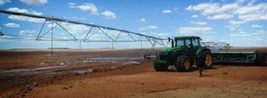
Some of these Government/mining company agricultural schemes are employing both remote sensing geophysics (airborne EM) to determine the impacts of setting up of large new irrigation schemes on the existing previously sparsely grazed soils, shallow groundwater systems and the semi-arid general ephemeral stream systems. For further information: – https://www.agric.wa.gov.au/sites/gateway/files/Irrigation%20in%20 Pilbara%20factsheet.pdfhttps://publications.csiro.au/rpr/ download?pid=csiro:EP127667&dsid=DS6 http://www.environment.gov.au/protection/assessments/strategic/ wa-pilbara-bhp