
By Marysol Mijares1,2, Michael Schmitz1,2, Javier Sánchez-Rojas2, Freddy Rondón1,2
1Simon Bolivar University, Earth Science Department, 1080 Caracas, Venezuela
2Venezuelan Foundation for Seismological Research – FUNVISIS, Applied Geophysics Department, 1070 Caracas, Venezuela
Abstract
Noninvasive geophysical techniques such as passive seismic methods are widely used in the characterization of urban settlements. In this study, we use the IMASW method, which combines Seismic Interferometry and Multichannel Analysis of Surface Waves (MASW), to study the averaged shear wave velocity in the upper 30 m (Vs30). A comparative analysis of the Vs models was performed using alternative methods such as ReMi (Microtremor Refraction Seismic) along with available geotechnical data. This study reports on the results from an integrated Vs30 map derived from spatial interpolation. Vs30 database was obtained from the IMASW method and added discriminated data from previous studies and different methodologies, such as Remi, empirical Vs-NSPT correlations, and topographic slope-based VS30. This main product allowed to determine soil site classes, which along with local geology and SPT soil strata reports, led to a first approximation of near-surface layer models of distinctive sites in the study area. Finally, we demonstrate the practicality and effectiveness of passive seismic interferometry for seismic microzonation purposes and site-effect analysis, especially in the context of urbanized areas and low-budget projects. In addition, the integration of Vs30 data retrieved from alternative techniques was useful to calibrate and verify the quality of the end results.
Introduction
The city of Valencia is the capital of the Carabobo state, located in the northern-central region of Venezuela, specifically on the western shore of Lake Valencia, adjacent to the endorheic basin of the lake. This Metropolitan Area (MAV) is one of the most important industrial, economic and demographic urban centers in Venezuela (Figure 1-A). Most populated urban centers in the country are located in the north coastal region and near important fault zones; this geographic situation puts the MAV’s population in the context of a high seismic hazard zone. In the last decades, the occurrence of earthquakes in the state of Carabobo has increased, especially in the municipalities where there is a tendency for population growth. Moreover, the amplification of seismic site effects is influenced by the sediment thickness of the urban basin and the quality of the soil present in the MAV, which consists mostly of Quaternary sediments, making them preliminarily susceptible to liquefaction phenomena (Pombo, 2018). To manage and mitigate seismic risk through earthquake-resistant buildings, the Venezuelan Foundation for Seismological Research (FUNVISIS) has created the “Seismic Microzonation Project,” seeking to delimit the seismic response in microzones that show relative uniformity in seismic excitation in the main cities of the country (Schmitz et al., 2015). In this regard, the study of the local conditions of the shear wave velocity, specifically the Vs30 parameter, defined as the average shear wave velocity in the first 30 meters of depth, is especially relevant since this parameter is related to the shear modulus and density of the material through which the waves propagate, and consequently, leads to estimating the amplification of site-effects (Borcherdt, 2012).
Passive seismic interferometry is a very useful tool for geophysical research in urban areas since it enables obtaining results with relative efficiency. This technique is based on the generation of new seismic responses derived from virtual sources by cross-correlating passive source signals. O’Connell and Turner (2011) postulate the Interferometric Multichannel Analysis of Surface Waves or IMASW method for the study of shallow subsurface or shallow depths, linking seismic interferometry with the Multichannel Analysis of Surface Waves (MASW) method proposed by Park et al. (1999). Thus, it is possible to obtain subsurface velocity profiles using the active MASW methodology applied to a multichannel seismic record derived from virtual sources.
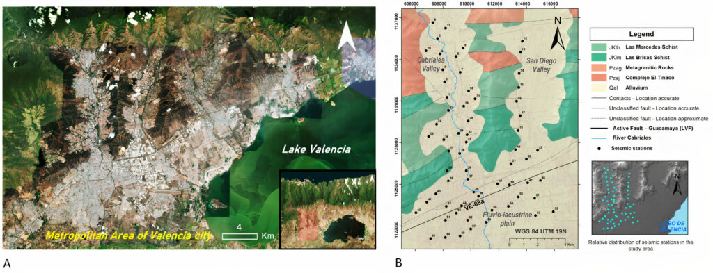
Figure 1. A) Satellite view of the city of Valencia (ArcGis Earth image), B) local geology of the study area (after Hackley et al., 2006, faults from Audemard et al., 2000) overlain by the distribution of the seismic stations (black dots) measured by Parra (2012).
Data
Data available for this project was provided by the Venezuelan Foundation for Seismological Research (FUNVISIS). A total of 64 multichannel seismic records of ambient noise were acquired in 2012, with instrumentation and equipment belonging to FUNVISIS (Parra, 2012). This previous project was carried out with the purpose of studying the shear wave velocity in the shallow subsurface using the surface wave method ReMi (Refraction Microtremor) proposed by Louie (2001). Seismic lines were distributed in the city of Valencia, across the municipalities of Naguanagua, San Diego, and Valencia, covering most of the northern metropolitan area of the city. According to Parra (2012), the seismic acquisition was accomplished with 48 geophones (resonant frequency of 4.5 Hz) adjusted to land-streamers and two digital seismographs. Each seismic line had a minimum length of 100 m, while seismic records consisted of 30 s time windows, with a sampling interval of 0.002 s, acquiring about 15 recordings per survey. Figure 1-B shows the distribution and numerical identification of the seismic stations in the study area, as established by Parra (2012). In addition to passive seismic data, this study was based on the processing and integration of geotechnical data. The last consisted of a Standard Penetration Test (SPT) spreadsheet database, which reported the location, date, depth, N-values, and stratigraphy of the penetration test. This type of geotechnical drilling test provides a measure of the relative density and penetration resistance of granular deposits, such as sands and gravels, using a thick-walled sample tube driven into the ground. Also, the precedent study of Márquez and Morales (2009) published a Vs30 database derived from empirical Vs-NSPT formulas using the NEHRP equation (BSSC, 2003). These empirical equations generally take the form of Vs=ANB, where the N value represents the standard penetration resistance in the SPT test (Marto et al., 2013). Additionally, the topographic slope is often used as a proxy for seismic site conditions. Hence, the available digital elevation model allowed the generation of a DEM-based Vs30 map by topographic slope approximation, according to the methodology of Allen and Wald (2007).
Study Area and Local Geology
The study area covers the western plain of Lake Valencia (south of the city) and extends toward two distinctive valleys, called ‘Cabriales’ (western valley) and San Diego (eastern valley). These valleys are separated by mountainous spurs that have origin in the Cordillera de la Costa mountain range. The Cabriales River is the most important river in the city and crosses the western valley with a meandering stream with an approximate north to south orientation. Lake Valencia’s basin is filled with Quaternary sediments of alluvial, lacustrine, and fluvial origin. According to local authors, these deposits could be made up of an irregular alternation of layers of clays, silts, sands, and gravels.
The tectonic context of the city is framed by dextral strike-slip fault systems; the most important active fault traces in the region, according to Audemard et al. (2000), are represented by the La Victoria Fault system (LVF). Local outcrops in the MAV consist mainly of geological units from the ‘Caracas Metasedimentary Association’ (specifically, Las Brisas Schist and Las Mercedes Schist), which outcrop in the mountain spurs that intercept the valleys of the city (Hackley et al., 2006). Figure 1-B shows local outcrops, main active fault traces, and geomorphologic sites of the study area.
Methods
The IMASW methodology consisted of three fundamental stages: (1) a basic signal pre-processing, including band-pass filters and spectral whitening; (2) cross-correlation between signals from all available geophone pairs, so that new seismic responses are generated, mathematically represented by empirical Green’s functions, thus obtaining, a multichannel seismic record of virtual sources; and finally (3) the MASW processing, with a standard active source methodology to retrieve a dispersion image, using the active linear FK analysis module of the Geopsy Software, by the SESAME Project (2005).
The interpretation of the dispersion image is based on identifying the apparent curve of the fundamental mode of Rayleigh waves, and for this purpose, the phase velocity-frequency pairs of maximum amplitude in the dispersive image are interpreted. In order to compare different methods and the qualitative relevance of the extracted dispersion curves, seismic data were reprocessed using the ReMi method, following Louie (2001), and then interpreting 64 additional dispersion curves. A comparative analysis was elaborated based on the Pearson correlation coefficient of the phase velocity with respect to frequency. Then, dispersion curves belonging to a specific seismic station were compared. ReMi dispersion images were obtained by a software developed by Sánchez and Díaz (2018), obtaining good resolution of the dispersive pattern in the frequency range of 4-25 Hz.
The inversion process of the dispersion curves was carried out using the Neighborhood Algorithm of the Dinver software, by the SESAME Project (2005), along with the parameterization of a theoretical geological model of horizontal layers. Thus, 1D shear-wave velocity models were obtained for the 64 seismic records available. Figure 2 shows an example of an extracted dispersion curve and its related velocity model resulting from the inversion process.
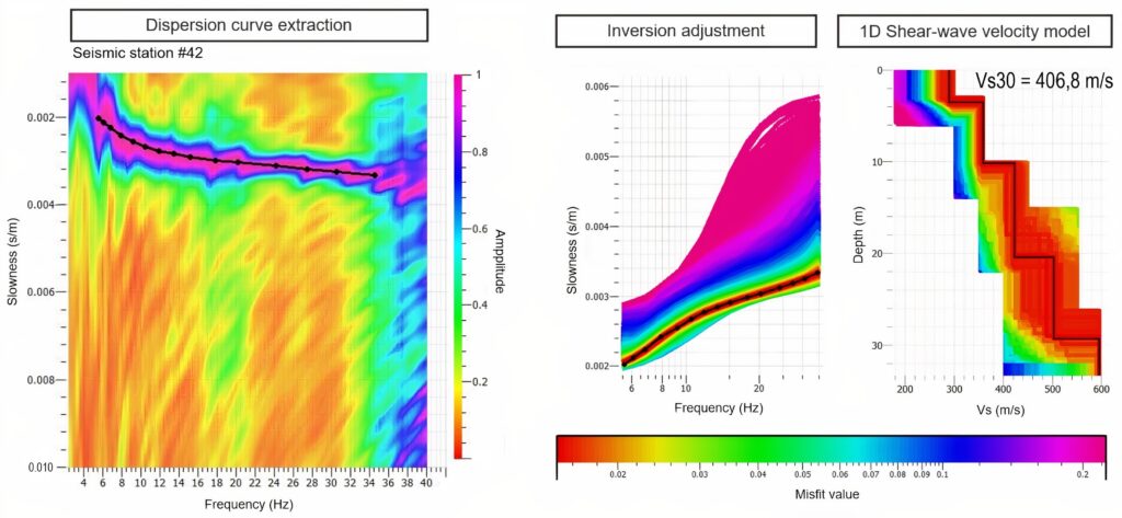
Figure 2. Example of dispersion curve from IMASW and associated Vs30 model (Seismic station #42), resulting from the inversion process.
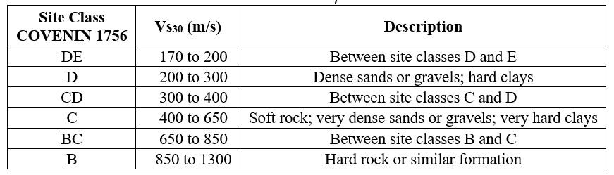
Information from the Standard Penetration Test (SPT) reports allowed us to obtain 1D profiles of Vs-NSPT using the empirical NEHRP conversion (BSSC, 2003). Ten SPT boreholes were chosen according to their depth and because of their convenient proximity to the seismic stations. In addition, lithological information from these geotechnical tests allowed us to generate two 2D geologic cross-sections located in the Naguanagua municipality (in the western part of the study area) and San Diego municipality (in the eastern part of the study area). These cross-sections were estimated using the Strater® 5 interpolation by Golden Software, Inc. (2021). Additionally, Marquez and Morales’s (2009) Vs-NSPT database was partially integrated, while most of the values were discarded. We chose to include Vs30-NSPT values whose borehole had 18 m of depth or more since lower depth Vs30 values did not correlate well with IMASW and ReMi results. The Vs30 values associated with each 1D shear-wave velocity model were classified using the updated version of the Venezuelan standard COVENIN 1756 (COVENIN, 2019). According to the mentioned seismic standard, Table 1 shows COVENIN’s site class definition in Vs30.
Table 1. COVENIN 1756 site classes in terms of Vs30 (COVENIN, 2019).
Results
Through the comparative analysis of extracted dispersion curves, it was found that the IMASW and ReMi-derived curves of this study are congruent with each other, with an average Pearson correlation coefficient of 0.84. However, the correlation between the IMASW and ReMi curves of the precedent work of Parra (2012) was less robust with an average correlation coefficient of 0.64, which was attributed to differences in each interpreter’s criteria for choosing the minimum velocity envelope in the ReMi’s p-f dispersion image. Additionally, dispersion images derived from the IMASW method were classified according to the quality of the trend of the maximum amplitude pattern. Seven of these dispersion images with a poor-defined amplitude pattern were discarded as valid data for the subsequent inversion analysis. In these cases, the dispersion image of the ReMi method was considered since the correlation analysis showed that the curves extracted by both methods could be considered for the inversion analysis expecting similar results in the velocity models.
Results of the inversion process allowed us to obtain 1D shear-wave velocity models for the 64 seismic records available, showing depths between 27-32 m and 3-5 layers, overall, showing a reasonable error associated with the minimum residual value (min misfit) no greater than 0.03. The vast majority of the 1D shear-wave velocity profiles showed increasing velocity with depth in the Cabriales river valley and in the San Diego valley. However, 1D shear-wave velocity profiles with low-velocity layers were also obtained; these results were mapped to analyze the geographical context along with possible causes of this velocity decrease.
Two geological cross-sections were estimated from the stratigraphic information of the SPT geotechnical reports. A cross-section called ‘1-SPT’, with a depth of 18 m, is located in the western part of the city in the Cabriales river valley. It shows a predominant lateral sequence of the SM lithotype, which refers to medium to coarse silty sands in the superficial strata with a maximum depth of 3 m, and in general, the CL lithotype (clay with fine sand) predominates throughout the profile for depths greater than 3-5 m. Cross-section called ‘2-SPT’ is located on the eastern side of the study area in the San Diego municipality and has a depth limited to the upper 8 m. It shows a monotonous stratigraphic trend throughout the section, where the CL lithotype predominates (clay with fine sand). Figure 3-A shows both estimated cross-sections; sediment nomenclature is based on the Unified Soil Classification System (USCS).
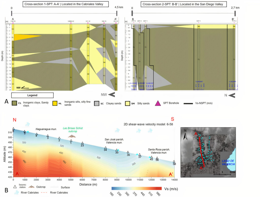
Figure 3. A) SPT-based cross-sections: section ‘1-SPT’ is located in the Cabriales Valley (left); section ‘2-SPT’ is located in the San Diego Valley (right). B) Sample of an interpolated 2D shear-wave velocity model, located along the Cabriales Valley, in the western part of the study area.
Furthermore, using local polynomial interpolation, several 2D shear-wave velocity profiles distributed in distinctive geomorphologic areas of the city were generated. With the help of the SPT stratigraphic data, the estimation of near-surface geological models was obtained. Figure 3-B shows an example of a 2D shear-wave velocity model derived from 1D models.
Using the kriging interpolation method, a Vs30 preliminary map was generated according to the gathered Vs30 database of this study, integrating data from the methods mentioned above (IMASW, ReMi, and Vs-NSPT empirical correlations). However, difficulties in the site-class definition were determined on the eastern part of the study area, specifically across the San Diego valley, due to low data density. Therefore, a final Vs30 map was generated by integrating, in addition, DEM-based Vs30 values retrieved from topographic slope approximation, following the Allen and Wald (2007) methodology.
Discussion
Overall, the IMASW method was able to retrieve more information on the dispersive characteristics of the subsurface in the low-frequency range and, therefore, allowed us to obtain better resolution of the deeper strata in the velocity models.
Shear-wave velocity models with low-velocity layers showed two types of trends according to the location of the models: a) low-velocity layers in the shallowest strata at approximately 5-15 m depth, specifically in some seismic stations located near the upper Cabriales riverbed; and b) low-velocity layers in the deeper strata of the profiles, approximately 20-30 m of depth, located in the alluvial plain of the Cabriales river, in its middle-lower channel, and to the south of the city with a greater tendency towards the lake plain in a southeasterly direction. The low-velocity layers in superficial strata were associated with the surrounding hydrography, mainly represented by the alluvial plain of the Cabriales river. There is a geographic coincidence on these velocity models with the proximity to the Cabriales River, specifically in lines 4, 5, 26, 35, and 37. In addition, these strata may be related to the water table, since, according to Holmquist and Ponce (1986), surface aquifers can be found in these geotechnical zones.
Results from the 2D shear-wave velocity models and SPT-derived geologic sections allowed us to interpret the following: along the western valley of Valencia (Naguanagua municipality and San José parish), an upper layer of about 15-20 m thick, with an estimated maximum Vs of 320 m/s. This layer is interpreted as granular soils derived from the Cabriales river valley, in accordance with zones I and II of the river basin’s geotechnical zonation, described in Holmquist and Ponce (1986). In the eastern valley (San Diego municipality), a surface stratum with an estimated thickness of 8-10 m, and an approximate maximum Vs of 385 m/s, is interpreted as clays with fine sand. It should be noted that geotechnical reports available corroborated the existence of the lithotypes mentioned above.
Likewise, in the southern part of the study area, shear-wave velocity models show a trend of low-velocity layers in the deeper strata (between 20-30 m of depth), which are interpreted as diatomaceous sediments of organic origin, which were buried by alluvial deposits associated with the lacustrine drying of Lake Valencia of Holocene to present age (Peeters, 1968); the latter are related to calcareous sediments identified as “Caracolillo Soils” (Planorbis Sp), which, according to Hernández (2006), are found overlying the deposits known as “Tierra de Diatomeas” (Diatom shells), of high porosity and relatively low density. It should be noted that each one of these deposits has been studied for its propensity to saturation and collapse phenomena by authors such as Hernández (2006). Figure 4-C shows three conceptual geological models for the near-surface strata related to three distinctive geomorphologic sites in the study area (Cabriales river basin, San Diego valley, and the southern lacustrine plain). This information may be useful as a theoretical layer model for future studies.
The integrated Vs30 map (Figure 4-A) showed a coherent increase in Vs30 towards the mountainous zones and a decrease towards the valley depocenters and the southern fluvial-lacustrine plain. However, SPT-based results highlight the decreasing trend of Vs30 towards the eastern side of the Cabriales River Valley, which is attributed to the soft, granular sediments of low-compaction located in the Cabriales valley referred from the geotechnical zonation of the river basin and the geological information consulted. Thus, it can be inferred that San Diego valley’s sediments may be of higher compaction and better quality than those of the Cabriales river valley, which is coherent with the geotechnical lithotypes found in the San Diego valley, where fine-grained sediments such as clays with fine sand are found.
Finally, site classification of the Vs30 map showed that soils of the study area are dominated by site class D, both in the centers of the alluvial valleys and towards the lake plain. Towards the mountain foothills, site classes vary from CD to C, while site classes B and BC (Vs30 > 650 m/s) are obtained specifically in the topographic highlands, which are generally non-urbanized mountainous areas. Figure 4 shows the main products of this study: an interpolated Vs30 map derived from data of different origins (ambient seismic noise, geotechnical empirical correlations, and DEM-based) and the site classification map of the study area, where site class D dominates.
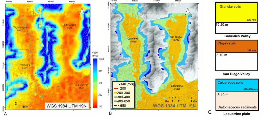
Figure 4. A) Final interpolated Vs30 map of the study area. B) Site classification map, derived from the gathered Vs30 results. C) Derived conceptual geological models for the near-surface strata in the study area.
Conclusions
This study shows that seismic interferometry and the Multichannel Analysis of Surface Waves (IMASW) is an alternative passive method to recover geophysical information from the shallow subsurface of an urban area. This method allowed us to reprocess precedent ambient seismic data to update the current Vs30 database of the Metropolitan Area of Valencia while obtaining better certainty of deeper strata in the velocity models compared to results derived from the ReMi method. The integration of geotechnical data was key to calibrating the quality of the results and analyzing shear wave velocity behavior. The integrated Vs30 map allowed us to determine that site class D (200-300 m/s) dominates in the soils of the study area, both in the centers of the alluvial valleys and towards the lacustrine plain.
We recommend integrating new geological studies to define the Quaternary units of the urban basin of the city, as well as assessments of liquefaction potential, especially in the south of the city and in the Cabriales river basin, since the sedimentary content interpreted in this area has been related to collapsible soils by several authors. The definition of site classes in the MAV is based on the recently approved national seismic code (COVENIN, 2019). This update of the previous Venezuelan seismic standard plays a fundamental role in determining seismic microzones and, therefore, in the prudent execution of civil and urban projects.
Seismic risk can be mitigated if local geophysical and geotechnical information of the subsurface is taken into account to generate accurate earthquake engineering criteria based on this information. Thus, we encourage the promotion of geophysical studies for seismic microzonation since having better-prepared cities to respond to seismic hazards is crucial for the quality of life of Venezuelan citizens and the reduction of human and economic losses in the event of an earthquake.
Acknowledgements
We thank the professors at Simon Bolívar University, and we extend special thanks to the staff of the Venezuelan Foundation for Seismological Research (FUNVISIS), Eng. Víctor Escobar and Eng. Javier Parra’s advice and support were fundamental in this project’s elaboration.
References
Allen, T., and Wald, D., 2007, Topographic Slope as a Proxy for Seismic Site-Conditions (Vs30) and Amplification Around the globe: Open-File Report 2007–1357, R. U.S. Geological Survey, Virginia.
Audemard, F., Machete, M., Cox, J., Dart, R., and Haller, K., 2000, Map and Database of Quaternary Faults and Folds in Venezuela and its Offshore Regions: U.S. Geological Survey (USGS), USGS Open-File Reports 00-0018.
Borcherdt, R., 2012, VS30 – A Site-Characterization Parameter for Use in Building Codes, Simplified Earthquake Resistant Design, GMPEs, and ShakeMaps: Conference: 15th World Conf. on Earthquake Engineering (15 WCEE Lisboa), p. 2.
BSSC, 2003, NEHRP recommended provisions for seismic regulations for new buildings and other structures (FEMA 450): Building Seismic Safety Council (BSSC), Washington.
COVENIN, 2019, Norma venezolana COVENIN 1756-1:2019 Construcciones sismorresistentes. Parte 1: Comisión Venezolana de Normas Industriales, FODENORCA, Caracas. Available online <http://www.sencamer.gob.ve/>
Hackley, P., Urbani, F., Karlsen, A., and Garrity, C., 2006, Mapa Geologico de Venezuela a Escala 1:750,000: U.S. Geological Survey (USGS).
Hernández, M., 2006, Estudio geológico y reconocimiento de arcillas expansivas en suelos de una zona al sur de Maracay, estado Aragua: Geophysical Engineering, Thesis Project, Universidad Central de Venezuela, p. 152.
Holmquist, J., and Ponce, C., 1986, Propiedades geotécnicas del subsuelo y estudio de las soluciones de fundación comúnmente usadas en el Área Metropolitana de la Ciudad de Valencia y sus alrededores: (zona industrial y Valle de San Diego): Civil Engineering, Thesis Project, Universidad Católica Andrés Bello, Caracas (1986).
Louie, J., 2001, Faster, Better: shear-wave velocity to 100 meters depth from refraction: Bulletin of the Seismological Society of America., vol. 91, i. 2, p. 347-364.
Márquez, J., and Morales, M., 2009, Elaboración de Mapa de Velocidad de Ondas de Corte Vs-30, a partir de base de datos existente y nueva del Área Metropolitana de Valencia, Civil Engineering, Thesis Project, Universidad de Carabobo, p. 172.
Marto, A., Tan, C., and Leong, T., 2013, Universal correlation of shear wave velocity and standard penetration resistance: Electronic Journal of Geotechnical Engineering, vol.18, p. 2727-2738.
O’Connell, D., and Turner, J., 2011, Interferometric Multichannel Analysis of Surface Waves (IMASW): Bulletin of the Seismological Society of America, vol. 101, i. 5, p. 2122-2141.
Park, C., Miller, R., and Xia, J., 1999, Multichannel Analysis of Surface Wave: GEOPHYSICS, vol. 64, i. 3, p. 800-808.
Parra, J., 2012, Caracterización Geofísica del Subsuelo Somero Mediante la Aplicación del Método de Refracción por Microtremores (ReMi) en la Ciudad de Valencia, Estado Carabobo: Geological Engineering, Thesis Project, Universidad de Los Andes, Mérida, p. 44-71.
Peeters, L., 1968, Origen y evolución de la cuenca del lago de Valencia, Venezuela: Instituto para la Conservación del Lago de Valencia, p. 66.
Pombo, A., 2018, Riesgo Sísmico en el Área Metropolitana de Valencia: Environmental Engineering, Doctoral Thesis, Universidad de Carabobo, Valencia, p. 75-78.
Sánchez, J., and Díaz, D., 2018, Programa en MatLab para el procesamiento de datos de Refracción de Microtremores (ReMi): JIFI 2018 – Jornadas de Investigación de la Facultad de Ingeniería, Universidad Central de Venezuela, Caracas.
Schmitz, M., Cano, V., López, O. A., Klarica, S., Pombo, A., Díaz, J. F., Heredia, J., Avendaño, J., Morales, C. and the seismic risk group of the Applied Research project for Integrated Risk Management in Urban Spaces, 2015, Estudios Geofísicos en Cuencas Urbanas en Venezuela con fines de Microzonificación Sísmica: BOLETÍN DE GEOLOGÍA, vol. 37, i. 1, p. 17-26.
SESAME Project (2005). Accessed 26 January 2021. <http://www.geopsy.org>
Author Bios

Marysol Mijares has a Bachelor of Science in Geophysical Engineering (2019) from Simon Bolivar University (Caracas, Venezuela) and also a specialization degree in Environmental Analysis and Management from the Postgraduate European Center (CEUPE). As a graduate geophysicist, she actively supports the ongoing Venezuelan Seismic Microzonation project of the country’s main cities, coordinated by FUNVISIS. marysolmmijares@gmail.com

Michael Schmitz has a Ph.D. in Geophysics from Freie Universitaet Berlin, (Berlin, Germany). Prof. Schmitz serves as an associate professor of Simon Bolivar University (USB) and the Central University of Venezuela (UCV). He currently works as a Senior Researcher at the Geophysics Department of FUNVISIS, leading the seismology, geodynamics, and seismic microzonation projects. Additionally, he has been the current president of the Venezuelan Society of Geophysical Engineers (SOVG) since 2020. schmitzschutt@gmail.com
Javier Sánchez-Rojas has a Ph.D. in Geophysics from Kiel University. He is an expert in geophysical exploration methods, with extensive experience in potential methods (Gravimetry, Magnetometry, etc.) and other surface waves techniques such as ReMi and MASW. He worked at the Geophysics Department of FUNVISIS for almost 18 years. He currently works as a Senior Geophysicist in Santiago, Chile. sanchjav7@gmail.com

Freddy Rondón has a Bachelor of Science in Geophysical Engineering (2016) and is an M.Sc. candidate in Earth Science of Solid Earth from Simon Bolivar University. He has extensive experience in research of potential methods and acquisition, processing, integration, and interpretation of Geoscientific Data (Gravimetric, Geoelectric, Magnetotelluric, Electromagnetic, GPS Observations, Satellite Images, Seismic Microzonation, Reflection Seismic, among others). He currently works as a researcher at the Geophysics Department of FUNVISIS. frondon255@gmail.com
