Professor Nigel Cassidy
Professor of Geotechnical Infrastructure Engineering,
University of Birmingham, UK
Welcome to the final edition of FastTIMES infrastructure and geotechnical geophysics news for 2020; I hope you have all managed to get through the year relatively unscathed. As I write this, the Christmas holidays are only a few weeks away and I (like many) will be looking forward to a break over the festive period. With vaccines being rolled out across many countries I am looking forward to 2021 and the up-coming conferences, workshops and meetings that will undoubtedly have us meeting up in person, at last.
Firstly, there is the EAGE’s Geophysical Monitoring Technology conference (GeoTech2021) at The Hague, Netherlands, 1-3 March 2021 which includes the 2nd EAGE workshop on Distributed Fibre Optic Sensing, see www.geotech.eage.org. This event fits nicely with the recent November 2020 edition of SEG’s Leading Edge on Distributed Acoustic Sensing (DAS) https://www.tleonline.org/ theleadingedge/november_2020, which includes an excellent article by Andrey Bakulin, Ilya Silestrov and Roman Pevzner on the use of DAS as a replacement for point source geophones for surface seismic surveys (see https://dx.doi.org/10.1190/tle39110808.1 “Surface seismics with DAS: An emerging alternative to modern point-sensor acquisition”). What I like about the article is the comparison between real seismic data collected by DAS and that of conventional geophones. The practical benefits/limitations of the DAS method are discussed in detail and it is particularly interesting to see how both methods compare in the context of shallow surface wave analysis and inversion for Vs velocities – a subject in my own expertise area. Please do have a look, the article is definitely worth a read. I would also like to recommend SEG/ AGU’s forthcoming on-line workshop on advances in distributed sensing (https://seg.org/Events/Distributed-Sensing-for-Geophysics), 10-12th February 2021, where the latest innovations in Distributed Fibre Optic Sensing (DxS) and Distributed Acoustic Sensing (DAS) will be the topics of discussion. All of this goes to show that DAS, and its variants, are a hot topic in the geophysical sector.
Later on in the year, EAGE will be holding its 82nd annual Conference and Exhibition, 14-17th June, in Amsterdam, Netherlands – https://eage.eventsair.com/eageannual2021/.
For many of us, this will be the first opportunity to meet our colleagues from the US and Europe in person and I, for one, can’t wait – I hope to see you there in the summer. Note that the abstract deadline is the 15th January 2021, so there is not a lot of time to get your submission in.
Last, but not least, of course… Don’t forget SAGEEP and the 1st Munitions Response Meeting 14-18 March 2021. On-line this year, topics range from “Transportation and Infrastructure
- Engineering, Monitoring & Evaluation” through to “Optical Sensing – DAS, Thermal, LIDAR & Multi-spectral Sensing”. I particularly like the look of the special sessions on “Correlating Geophysical and Geotechnical Parameters” and “Proximal Soil Sensing using Geophysical Techniques” and would very much encourage you attend. Again, I look forward to seeing you there
- albeit digitally.
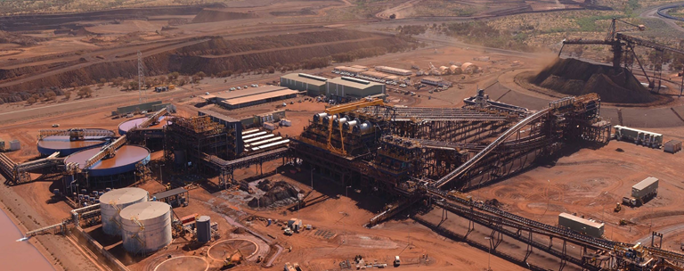
Moving on to more technical matters… Mining geophysics, the subject of this edition, overlaps considerably with geotechnics and infrastructure geophysics as many of the technologies (and users) are the same. Technological developments from other engineering sectors tend to drive our own methodological advances and the excellent articles in the previous FastTIMES edition on UAV geophysics illustrates this perfectly. Drone technology is advancing at pace and we, as a community, can all benefit from the new delivery platforms that autonomous UAV systems can provide. With this in mind, I was stuck by how the latest developments in micro-drone technology could be ‘game changing’ for mining and cave/karst geophysics.
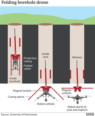
A consortium of UK Universities, Robotics companies and AI specialists, supported the UK’s national rail network operator (Network Rail), is developing a borehole-deployed drone for mapping sealed caves and cavities. Inserted into the cavity through a 6-inch borehole, the drone unfolds its flight arms, drops into the cavity then autonomously maps the space with Lidar
and infrared cameras (using complex AI to avoid crashing into the cavity walls). Once done, the drone flies back to the borehole docking station where it is recovered in order to access the Lidar and IR mapping data.
Inspired by the spherical laser mapping drones featured in Ridley Scott’s 2012 prelude to the Alien films, Prometheus, the project (also called Prometheus in a nod to the film) incorporates miniaturised infrared optics and 3D laser mapping capabilities (https://prometheusdrone.co.uk/). Featured in a recent BBC business news article (https://www.bbc.co.uk/news/ business-55191623) the project has been partially financed by the UK government under the Industrial Strategy Challenge Fund, “Robotics and AI in Extreme Environments” to provide the innovation push needed to tackle long-standing geotechnical problems faced by our 200 year-old Railway infrastructure. It’s a work in progress and the latest technical paper in the open access Journal “Robotics” describes the development of the drone and its testing under laboratory conditions (The Design of Prometheus: A Reconfigurable UAV for Subterranean Mine Inspection https://www.mdpi.com/2218-6581/9/4/95/htm). For me, the really interesting part of the project is the miniaturisation of the laser scanning technology. Driven by the need for real-time, ‘3D landscape’ characterisation coming out of autonomous robot research programmes, “micro-Lidar” is also the next big thing in tablet innovation. The recently launched iPad Pro includes a Lidar scanner that is capable of ultra-fast 3D laser scanning of objects up to a range of approximately five metres. It is clearly aimed at the augmented reality market but, when merged with the video images from the on-board high-definition UHD photogrammetry, the technical possibilities for engineers, geophysicists and geoscientists are, well, boundless…
https://www.apple.com/uk/newsroom/2020/03/apple-unveils-new-ipad-pro-with-lidar-scanner-and-trackpad-support-in-ipados/
I suspect this technology will soon translate over to other mobile devices with the tantalising prospect of ‘citizen science’ (i.e., the collection of geodata by the public for public good) becoming mainstream in scientific and academic circles. Very interesting developments – Christmas present anyone? The issue is going to be how we store, characterise and accurately interpret the huge volumes of data such technologies will create. Data provides knowledge but not necessarily understanding and I see a future where data becomes just ‘too big’ for humans to handle effectively. This brings us back to the topic of Machine Learning, AI and the handling of ‘big data’ in the geosciences. As the forward to the ‘Machine Learning and AI’ special section of October’s 2020 issue of SEG’s Leading Edge (https://www. tleonline.org/theleadingedge/october_2020) explained, “…data- driven approaches should not become a black box”. These are interesting times for all of us – watch this space I feel.
And finally… if you are looking for some quiet geophysical contemplation over the festive period, I can recommend SEG’s excellent series of in-depth conversations in applied geophysics “Seismic Soundoff” going back to 2016. These 15-20 min audio podcasts cover topics from machine learning through to career development in Geophysics. With nearly a hundred of them available from SEG’s web site (https://seg.org/podcast), there is definitely something for everyone in the archive.
As always, we would love to hear about your experiences. Please do send your articles to: [email protected] or the incoming Editor-in-Chief, German Ojeda, editorfasttimesnewsmagazine@ gmail.com, as whatever you have will be of interest to our community.
Thank you and best wishes for the festive period – look forward to seeing you all in the New Year,
Nigel Cassidy