
Ron Bell
geoDRONEologist
IGS, LLC, Denver, Colorado, USA
[email protected]
The business of geophysical data collection by drone is, in a word, exploding. Drone magnetic surveys have become the norm – if not a standard operating procedure – for a number of ground geophysical companies, more or less attributable to the availability of drone enabled magnetometers and affordable unmanned aerial vehicles from DJI, the American-style business success story located in China.
Several “traditional” near surface engineering and environmental geophysical markets are beginning to warm-up to the concept of using drones, with GPR leading the way in Europe, if not North America. New drone events are being considered now that the early adopters have realized they need to inform and educate the customers paying for the services, rather than continuing to cater to the drone nerds. The big money has been in the use of drones for inspections. In the very near future, the focus will be on using drones to detect and delineate what lies within the subsurface.
Thus, it is safe to say, many within the scientific discipline of geophysics are demanding for drone and sensor relevant educational content and shouting out a call to establish guidelines and standards for drone geophysical remote sensing data. For many environmental geoscientists and geotechnical engineers, 2021 will be remembered as the “Year of the Drone” as utilization of these airborne tools of automated data collection rapidly expands.
FAA Issues New Drone Rules
On December 28, 2020, the Federal Aviation Administration (FAA) announced final rules for unmanned aircraft systems (UAS). Within the 470 page document, the requirement for Remote Identification (aka “Remote ID”) will be the rule of the land in 23 months staving off, at least for the near term, a requirement to maintain an internet connection while conducting drone flights. We also learned that under certain conditions operators of small drones will be allowed to fly over people and conduct nighttime flight operations. To learn more, click on the following link
In my humble opinion, the new rules are important and significant steps in the right direction towards achieving the holy grail of “dronedom” otherwise known as the unmanned traffic management (UTM) system and beyond visual line of sight (BVLOS) flight operations.
UAV Geophysics Guidelines and Standards
Increasingly, research, engineering, environmental, and exploration geophysicists as well as geophysical practitioners not formally trained in the ways of geophysicists are deploying drones to collect geophysical data. Concerns about data quality were expressed by several presenters at the recent Summit on Drone Geophysics highlighting the need for industry standards for drone magnetic data collection. This led to discussions about the best practices for drone geophysical surveys which, in turn, resulted in the formation of the Near Surface Geophysics (NSG) Inter-society Committee on UAV Geophysics Guidelines and Standards, a moniker in dire need of a short form. I will beg off the tendency to devise an acronym by rather unofficially and simply referring to it herein as “The Guidelines Committee”.
Encouraged and facilitated by Geoff Pettifer, the outgoing Editor of the FastTIMES, and attended by Rainier Wackerle, Irina Filina, Ed Cunion, Johannes Stoll, Callum A. Walker, Jean Legault, Jeff Gamey, Steven van der Veeke, Elizabeth Baranyi, and Dennis Woods, The Guidelines Committee met on November 25, 2020. They achieved the remarkable outcome of a draft of table of contents (TOC) for the chapters to be included in the drone geophysics guidelines and standard document. The committee met again on December 15 which resulted in the creation of a set of sub-committees, each tasked to focusing on developing a chapter.
The intent of document is to inform and educate those wishing to integrate drones into their geophysical workflows. The Guidelines Committee will submit the Draft and Final document to participating near surface geophysics (NSG) societies for review, comment, finalization, and, ultimately, endorsement. Fundamental to the enterprise is bringing together the relevant experience and practices known to the pilot-on-board airborne geophysical community with the knowledge and experiences gained by the ground geophysical community currently deploying drones to collect geophysical data for near surface investigations.
Due to its world-wide usage, the drone magnetometry guideline document will become the de-facto template for the chapters on the other geophysical methods, for example. ground penetrating radar, electromagnetics, and gamma ray spectrometry. The vision for the document is to include chapters on survey planning, data processing, drone technology, navigation, flight operations, and local regulations.
This is an ambitious effort achievable only through efforts of many. The committee can use your help. Please join us as a contributor on a topic or a reviewer of content or as a compiler.
To learn more, email
Ron Bell at [email protected]
Geoff Pettifer at [email protected]

A Successful On-line Workshop
Over the course of three (3) days, November 4, 5, and 6, the Near Surface Technical Section of the Society of Exploration Geophysicists (SEG NS) conducted an on-line technical workshop on the application of drones to the collection of geophysical data. 130 registrants tuned in to take in the 17 technical presentations covering drone magnetics, GPR, gamma ray spectrometry, and EM data collection and processing. Morgan Sander-Ohloeft and Ron Bell served as hosts providing a brief introduction to the presenters and ensuring compliance with the agenda.
Originally intended as an eight (8) hour technical workshop, the event was re-formulated as three (3) hours of presentations with an hour of discussion spread out over three (3) days to make it more accessible and less fatiguing for the attendees. The event included presenters from Europe, Australia as well as North and South America, effectively bridging a multitude of time zones.
Rick Miller, the recent Past President of the SEG kicked off with a set of remarks welcoming the participants and noting the significant role drones currently have in the collection of high-definition magnetic data today and the rapidly expanding utilization of drone technology in the foreseeable future.
Day One began with a visionary presentation by Jan Franke of Groundradar Inc. who presented a detailed roadmap of geophysical sensors. Elizabeth Baranyi of Seequent presented on advantage of drones and the issues with processing and visualizing geophysical data collected using a UAV. The next three talks were on the use of drone GPR: Jaana Gustafson of Guideline Geo discussed geologic mapping applications, Cian Dawson of the USGS discussed using drone GPR for hydrologic studies, and Kristaps Brass of SPH Engineering presented the lessons learned conducting drone GPR over course of two years. The day ended with a robust Q&A session followed by a discussion on drone GPR and the future of drone geophysics.
Day Two focused exclusively on drone magnetics. The first presentation was by Irina Filina of the University of Nebraska on the development of a low-cost drone magnetic system by one of her students. Ed Cunion of Red Rocks Geophysical Consulting followed with a presentation on a development of a fluxgate vector magnetometer and its application over a closed landfill. Johannes Stoll of Mobile Geophysical Technologies, Inc. presented on use of a development drone magnetic system consisting of five (5) fluxgate magnetometers and how it is applied to UXO detection. Rainer Wackerle of Intrepid Geophysics presented the data processor’s point of view when tasked with processing airborne magnetic acquired with a drone. Ron Bell of IGS, LLC spoke about a number
of the lessons learned over the course of four (4) years of drone magnetic surveys. Juan Ortega of Collier Geophysics presented a case history on the use of UAV Magnetics to locate legacy O&G wells. The last presentation for the day was on the challenges, results, and safety concerns pertaining to the execution of a UAV magnetic survey for mineral exploration in Peru by Jose Arce of Arce GeoFiscicos SAG. The presentations were followed by a robust Q&A session of the presenters and a in depth discussion on the various applications and challenges of drone magnetic surveys.
Day Three began with an intriguing presentation on the using drones to collect gamma ray spectrometer data by Steven Van der Veeke of Medusa Radiometrics. Ron Bell of IGS LLC presented his work on the acquisition of a EM conductivity data at ultra-low altitudes. This was followed by Johannes Stoll of Mobile Geophysical Technologies presenting on the novel use of a Multicopter drone to collect semi-airborne electromagnetic data. Brandon Ray of Southern Geoscience Consultants spoke on processing of UAV magnetic data and planning UAV magnetic surveys. The final presentation was by Callum Walter of Queen’s University on the characterization and mitigation of EM noise generated by a drone. The Q&A session was followed by summary of the workshop and extended discussion on the need for a set of standards and / or guidelines pertaining to drone geophysics.
The Summit on Drone Geophysics was an epic event. All presentations were recorded and will be available free of charge to all paid registrations through the SEG On-line store. If you wish to review the presentations but were not able to attend the live event, you will be able to gain access through the purchase of a post event registration. As of this writing, the SEG were close to making the presentations available. To learn more, contact
Ms. Laurie Whitesell
tel: +1.918.497.5573 direct email: [email protected]
Drones for Geophysics
Bay Area Geophysical Society January 21, 2021 – 5:00 PM Pacific Time
If you are reading this before 5 PM Pacific Standard Time on January 21st AND you are interested in learning about my latest adventures in drone geophysics, check out the following
www.bayareageophysicalsociety.org
Alternatively, send an email to [email protected]
contact ???? about registering for the on-line event. The cost to do so is simply the $10 annual membership fee in the Bay Area Geophysical Society.
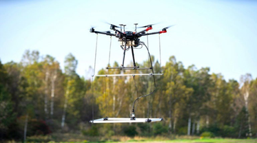
The Geonics EM61-lite
If there was ever an affirmation of the efficacy of drones applied to geophysical data collection, the recent announcement by SPH Engineering that Universal ground Control Software (UgCS) supports the Geonics EM61-lite deep penetrating metal detector is it. You can literally imagine the roar of a pilot-on-board helicopter being replaced by the heart-warming electrified buzz of the modest DJI Matrice 600 Pro hexacopter executing a autonomous mission in search of munitions of concern or an abandoned metallic holding tank. Be prepared to witness, figuratively speaking, an explosion in the use of drones in this market segment.
I urge you to check out the following UgCS TV video of the showing the EM 61 lite under
For more info on the EM61-lite, call Mike Catalano
+1 (905) 670 9580 ext. 250

To learn more about UgCS, check out the following link
Ground Station Software | UgCS PC Mission Planning
Drones and Sensors for Geoscience October 2021 – Denver, CO
I believe that there is a collective desire throughout the geoscientific community to learn about the requirements, necessities and options pertaining to the use of small unmanned aerial systems (UAS) to collect geophysical and remote sensing data. As a result, I am currently exploring the concept of creating a “gathering-style” event focused on the demonstration of drones and sensors applied to the collection of geophysical and remote sensing data. I recently reached out to a Colorado based industry trade association to open the discussion about producing such an event in October 2021 in the Denver, CO area.
I envision a three (3) day educational event consisting of field demonstrations and classroom style presentations on drone and sensor technology including the software used to plan and control the missions and post process the data.
If you are interested either as an attendee or as a content contributor, please express your interest by emailing me at [email protected].
Ending Remarks
This is my last geoDRONE Report© column in a traditional hard-copy, print-centric format to be published as a column in the FastTIMES. Future issues of the FastTIMES will be published in an HTML format for on-line consumption. I expect these will mean a more dynamic means for conveying news about drone geoscience events and technology. Admittedly, I have only a glimmer of an idea what this will mean for the geoDRONE Report©. Nevertheless, I am excited about exploring and implementing the technology that will facilitate a more interesting and readable column.
If this is your first time reading this column, Thank You! I sincerely hope the time you invested worth the commitment. If you are a regular reader or a content provider, I am grateful for your support and the content. I sincerely hope you will continue to demonstrate your support through emailing content to me or just by taking to time to read.
-Ron
The geoDRONE Report© is a copyrighted publication of Aerobotic Geophysical Systems, LLC located in Lakewood, CO. I am always looking for news and information content pertaining to the application of drones to geophysical and geoscientific mapping. If you have an item to share with the readers, please do not hesitate to contact me at rbell@ igsdenver.com.
