
Geoff Pettifer,
This issue of the FastTIMES Archaeological and Forensic Geophysics News Column, addresses the theme of Vol 25, 4, briefly focusing on the use of geophysics for mapping old mining operations, from ancient times to recent historical times.
My own geophysical survey experience has covered a range of archaeological geophysics applications for old mine workings including: –
- Use of GPR, Magnetics and GEM2 EM for mapping, as part of archaeological mapping, of two derelict mounds that represented two ancient (?4th Century BCE or later) mound remnants of derelict local Buddhist temples that were located within the proposed footprint of a proposed large coal mine open pit in Bangladesh (Figure 1).
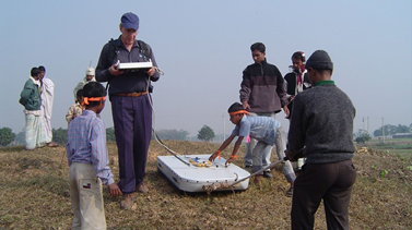
The plan was to survey, document and excavate the sites and if the site was considered to be of significance (there are estimated to be hundreds of such local Buddhist temple site mounds across the floodplains of Bangladesh), in the event that the mine went ahead, dismantle the temple remains brick by brick and relocate the structure to a safe area. The objective of the geophysical survey was to attempt to outline the clay brick foundations of the temple, there being two historical building styles, of distinct historical periods either a square shaped foundation or a cross- shaped foundation (essentially a square with four “naves”). Both foundation styles, were of particular, but differing archaeological interest. The site was extensively damaged due to (historical up to modern day) plundering of the site for clay bricks for kitchen floor paving of local village houses. The site was memorable also because it was daily desecrated by its use as an open-air toilet! This required someone getting the short straw each day for the site clearing task. These joys of archaeological field work one does not get prepared for from a text book or at university, but on the job as it were. Needless to say, the geophysical surveys were not totally conclusive, other than to suggest the smooth low mounds probably concealed simple square foundations, GPR
being the most useful technique.
- Various geophysical surveys for 19th century vertical gold mine shafts for a range of applications including (1) new mining operations tailings dams and mapping areas of potential leakage into shafts, (2) foundations for large water tanks and commonly
(3) general safe clearance of areas for new development or clearing a site for public recreational use. These shafts often could be only partially capped by buried wooden platform caps that were rotten and could collapse at any time or the shafts could be totally backfilled. GEM2 or EM31 and sometime magnetics or GPR was used to define these shafts and the capping / backfill status, with variable success.
- Surveying of evidence of early 20th century black coal mine
– pillar mining on the outskirts of expanding urban areas for land planning uses. LiDAR was used for identifying areas of subtle subsidence. ERI and seismic methods were used for detailed mapping of suspect areas to detect and verify the presence of cavities (or not).
- An interesting application was to attempt to map, akin to an industrial archaeology investigation, the location of tunnels and likely retorts/kilns etc for a poorly documented, late 19th century shale oil refinery site for the purposes of safely rehabilitating and also documenting the site as an historical site for tourist purposes. A GEM2 system was used to define EM anomalies (high and low conductivity for follow-up investigation by archaeologists.
- Finally, mapping of historical mining community gravesites and townsites by normal archaeological geophysical methods was often called for.
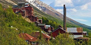
These applications illustrate that geophysics can be used to assist archaeological mapping or to define historical mine hazards around totally demolished mining areas or more intact recently decommissioned mining operations and ghost mining towns such illustrated in Figure 2.
Ancient Mines, Archaeo- metallurgy and Geophysics
The whole subject of investigation of ancient metal working sites (mines and smelters) is comprehensively covered in a publication covering three sections of the topic, entitled:
Justine Bayley, David Crossley and Matthew Ponting, 2008 – Metals and metalworking: A research framework for archaeometallurgy. The Historical Metallurgy Society Occasional Publication No 6. https://www.researchgate.net/publication/271133104_Metals_and_ Metalworking_A_Research_Framework_for_Archaeometallurgy.
The first section, aimed at planners, covers the scale from landscapes and townscapes to sites and structures; dealing with the management and protection of the resource. The second section, focuses on methods in historical metallurgy, from laboratory work to field archaeology, landscape survey, geo-prospection and experimental archaeology, and the skills of metal-smiths and palaeo-environmentalists. As documented in FastTIMES Vol 25, 2, p234-136, the approach taken is to treat the site as specialised contaminated land, including geophysical and geochemical methods among many other methods of investigation. The third section summarises what is known about ferrous and non-ferrous metalworking from the Bronze Age to the Iron Age.
In terms of archaeo-geophysics, magnetic surveys are extensively used. The literature documents many case histories of the use of magnetics to document and map ancient iron mines and iron smelting works. In some cases, copper mine sites have been surveyed also. Case histories in the literature document such investigations in the UK, Europe and the Sudan, wherever iron age or medieval metal mine works were located. Magnetic and magnetic susceptibility anomalies can be associated with: –
- Slag heaps around smelting sites.
- Kilns used for smelting either empty or containing residual slag material. Baked clays associated with smelters.
- Permanent alteration of soil magnetic susceptibility due to long or short term storage of iron ore that may or may not have been removed from the site.
- Iron ore mine mining shafts and workings.
Because of the use of heat in smelting operations, palaeomagnetics is a consideration in interpreting the magnetic anomalies and in some cases, this factor has been used to do palaeomagnetic dating of some smelting sites as Europe and parts of Britain have good documentation of the magnetic pole wandering. This subject of palaeomagnetic dating is well documented in a paper entitled: –
Gregg Mcintosh and Gianluca Catanzariti, 2006 – An Introduction to Archaeomagnetic Dating. GEOCHRONOMETRIA Vol. 25, pp 11-18. https://www.researchgate.net/publication/281738965_An_ introduction_to_archaeomagnetic_dating
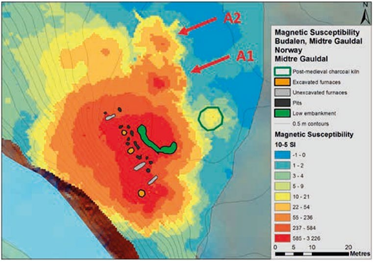
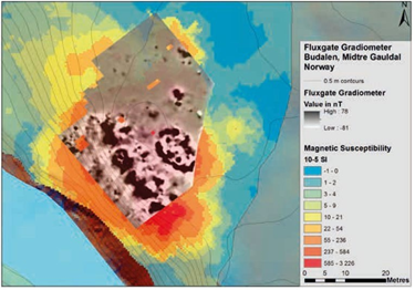
Case Example: Torbekken Viking Age iron foundry site, Norway
http://www.dknvs.no/wp-content/uploads/2019/07/DKNVS_ Skrifter2_2019_Scr.pdf
A recent example of use of a fluxgate gradiometer magnetic survey along with soil magnetic susceptibility, from Norway is documented in:
Arne Anderson Stamnes, Lars F. Stenvik and Chris Gaffney, 2019 – Magnetic geophysical mapping of prehistoric iron production sites in central Norway. In Arne A. Stamnes, Ole Risbøl & Lars F. Stenvik (Eds.), 2019 – Investigating early iron production by modern remote sensing. Skrifter nr. 2-2019. The Royal Norwegian Society of Sciences and Letters, Trondheim.
Several sites were surveyed with Bartington equipment. Figure 3 (from their paper) shows an example of clear soil magnetic susceptibility and overlaid fluxgate magnetics anomalies around pits and furnaces for a site at Torbekken.
The same publication in a separate paper, documents how LiDAR has also been used to locate mounds associated with (see iron smelting sites in Norway Figure 4 example, opposite, from Eleverum study area, Norway).
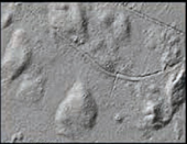
Figure 4. LiDAR mounds – evidence of slag heaps, Elverum, Norway SOURCE:
Ole Risbøl and Lars Gustavsen, 2019 -Mapping early iron production features in woodland using remote sensing techniques. In Arne A. Stamnes, Ole Risbøl & Lars F. Stenvik (Eds.), 2019 – Investigating early iron production by modern remote sensing. Skrifter nr. 2-2019. The Royal Norwegian Society of Sciences and Letters, Trondheim
